Login
Register


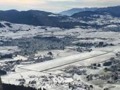
LIDA
Asiago Airport
VFR Chart of LIDA
Sectional Charts at SkyVector.com
IFR Chart of LIDA
Enroute Charts at SkyVector.com
Location Information for LIDA
Coordinates: N45°53.27' / E11°31.00'View all Airports in Veneto, Italy.
Elevation is 3409.0 feet MSL.
Operations Data
|
|
Nearby Navigation Aids
|
| ||||||||||||||||||||||||||||||||||||||||||||||||||||||||||||


Runway 08/26
| Dimensions: | 3675 x 75 feet / 1120 x 23 meters | |
|---|---|---|
| Surface: | Hard | |
| Runway 08 | Runway 26 | |
| Coordinates: | N45°53.10' / E11°30.58' | N45°53.24' / E11°31.34' |
| Elevation: | 3340 | 3407 |
| Runway Heading: | 075° | 255° |
| Displaced Threshold: | 230 Feet | 98 Feet |
Nearby Airports with Instrument Procedures
| ID | Name | Heading / Distance | ||
|---|---|---|---|---|
 |
LIDT | Trento/Mattarello Airport | 296° | 18.3 |
|
LIPT | Vicenza Airport | 178° | 19.0 |
|
LIPS | Treviso Istrana Airport | 116° | 26.9 |
|
LIPH | Treviso/S.Angelo Airport | 116° | 31.9 |
|
LIPB | Bolzano Airport | 347° | 35.3 |
|
LIPX | Verona/Villafranca Airport | 222° | 39.6 |
|
LIPZ | Venezia/Tessera Airport | 122° | 42.0 |
|
LIPV | Venezia/Lido Airport | 126° | 45.9 |
|
LIPA | Aviano Airport | 078° | 46.1 |
|
LIPO | Brescia/Montichiari Airport | 241° | 57.0 |
|
LIPL | Ghedi Airport | 242° | 59.2 |
|
LIPI | Rivolto Airport | 084° | 64.4 |