Login
Register


LXV
Lake County Airport
Official FAA Data Effective 2024-04-18 0901Z
Chart Supplement

VFR Chart of KLXV
Sectional Charts at SkyVector.com
IFR Chart of KLXV
Enroute Charts at SkyVector.com
Location Information for KLXV
Coordinates: N39°13.17' / W106°18.99'Located 02 miles SW of Leadville, Colorado on 605 acres of land. View all Airports in Colorado.
Surveyed Elevation is 9933 feet MSL.
Operations Data
|
|
Airport Communications
| ASOS: | 118.375 Tel. 719-486-8441 |
|---|---|
| UNICOM: | 122.800 |
| CTAF: | 122.800 |
| AWOS-3 at CCU (17.1 NE): | 118.075 970-968-1715 |
| AWOS-3 at 7BM (25.6 S): | 132.050 303-512-4419 |
| ATIS at ASE (25.7 W): | 120.4 |
- APCH/DEP CTL SVC PRVDD BY DENVER ARTCC (ZDV) ON FREQS 119.85/363.15 (ASPEN RCAG).
Nearby Navigation Aids
|
| ||||||||||||||||||||||||||||||||||||||||||||||||


Runway 16/34
| Dimensions: | 6400 x 75 feet / 1951 x 23 meters | |
|---|---|---|
| Surface: | Asphalt in Good Condition | |
| Weight Limits: | S-20, D-20 | |
| Edge Lighting: | Medium Intensity | |
| Runway 16 | Runway 34 | |
| Coordinates: | N39°13.69' / W106°19.10' | N39°12.65' / W106°18.87' |
| Elevation: | 9930.7 | 9924.6 |
| Traffic Pattern: | Right | Left |
| Runway Heading: | 170° True | 350° True |
| Markings: | Non-Precision Instrument in good condition. | Non-Precision Instrument in good condition. |
| Glide Slope Indicator | P2L (3.00° Glide Path Angle) | P2L (3.00° Glide Path Angle) |
Helipad H1
| Dimensions: | 150 x 100 feet / 46 x 30 meters | |
|---|---|---|
| Surface: | Asphalt-Concrete in Fair Condition RY H1 HAS 6-8 INCH LIP ALL AROUND EDGES; CONCRETE HAS LONGITUDINAL & CORNER CRACKING. | |
| Coordinates: | N39°13.21' / W106°18.92' | N0°0.00' / E0°0.00' |
| Elevation: | 9958.0 | |
| Markings: | Non-Standard in good condition. | |
Services Available
| Fuel: | 100LL (blue), Jet-A |
|---|---|
| Transient Storage: | Hangars,Tiedowns |
| Airframe Repair: | NOT AVAILABLE |
| Engine Repair: | NOT AVAILABLE |
| Bottled Oxygen: | NONE |
| Bulk Oxygen: | NONE |
| Other Services: | CHARTER SERVICE |
Ownership Information
| Ownership: | Publicly owned | |
|---|---|---|
| Owner: | COUNTY COMMISSIONER | |
| LAKE COUNTY COURTHOUSE | ||
| LEADVILLE, CO 80461 | ||
| 719-486-4181 | ||
| Manager: | BRETT COTTRELL | |
| 915 CR 23, BOX 952 | ||
| LEADVILLE, CO 80461 | ||
| 719-486-0307 | ||
Operational Statistics
| Single Engine Aircraft Based on Field: | 5 | Statistics collected for 12 month period ending 2018-05-18 | |
|---|---|---|---|
| Multi-Engine Aircraft Based on Field: | none | Annual Commercial Operations: | none |
| Jet Aircraft Based on Field: | none | Annual Commuter Operations: | none |
| Helicopters Based on Field: | none | Annual Air Taxi Operations: | 200 |
| Military Aircraft Based on Field: | none | Annual Military Operations: | 2000 |
| Gliders Based on Field: | none | Annual GA Local Operations: | 1800 |
| Ultralights Based on Field: | none | Annual GA Itinerant Operations: | 1000 |
Other Remarks
- OBSTRN LGTS ON BCN TWR.
- FOR CD CTC DENVER ARTCC AT 303-651-4257.
- ALL TWYS & NEW RAMP AREA MKD WITH BLUE & WHITE REFLECTORS.
- TWY C AND OLD RAMP HAVE POTHOLES & LOOSE AGGREGATE.
- RY H1 HAS 20-30 FT TREES 130 FT EAST OF PAD.
- ALL PAVEMENT EDGES HAVE SOFT SHOULDERS.
- RY 34 HA +50 FT POWER LINES 750 FT RIGHT OF THRESHOLD.
- ACTVT PAPI RWY 16 & 34; MIRL RWY 16/34 - CTAF.
Weather Minimums
Instrument Approach Procedure (IAP) Charts
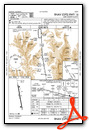
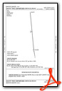
Departure Procedure Obstacles (DPO) Charts
Nearby Airports with Instrument Procedures
| ID | Name | Heading / Distance | ||
|---|---|---|---|---|
 |
KASE | Aspen-Pitkin County/Sardy Field Airport | 270° | 25.7 |
|
KAEJ | Central Colorado Regional Airport | 159° | 26.0 |
|
KEGE | Eagle County Regional Airport | 312° | 37.7 |
|
KANK | Salida/Harriett Alexander Field Airport | 162° | 42.7 |
|
20V | Mc Elroy Airfield Airport | 357° | 50.1 |
|
KGUC | Gunnison-Crested Butte Regional Airport | 215° | 50.2 |
|
KGNB | Granby-Grand County Airport | 019° | 55.4 |
|
KRIL | Rifle Garfield County Airport | 286° | 68.2 |
|
KBJC | Rocky Mountain Metro Airport | 053° | 69.3 |
|
KAPA | Centennial Airport | 072° | 71.4 |
|
1V6 | Fremont County Airport | 129° | 73.9 |
|
KEIK | Erie Municipal Airport | 050° | 75.5 |
Airport Images

By: brb

By: lxv9934


Comments
Nice and High
Excellent freshly rebuilt runway. Nice terminal and pilots lounge. If the terminal is closed, the pilots lounge is around back. Courtesy van available.