Login
Register


LZU
Gwinnett County/Briscoe Field Airport
Official FAA Data Effective 2025-11-27 0901Z
Chart Supplement

KLZU Airport Diagram

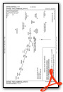
VFR Chart of KLZU
Sectional Charts at SkyVector.com
IFR Chart of KLZU
Enroute Charts at SkyVector.com
Location Information for KLZU
Coordinates: N33°58.69' / W83°57.74'Located 02 miles NE of Lawrenceville, Georgia on 520 acres of land. View all Airports in Georgia.
Surveyed Elevation is 1061 feet MSL.
TPA FOR LIGHT ACFT 1039 FT; TPA FOR JET & TURBO PROP ACFT 1539 FT.
Operations Data
|
|
Airport Communications
| ATIS: | 132.275 |
|---|---|
| AWOS-3PT: | Tel. 770-339-7753 |
| GWINNETT TOWER: | 124.1 |
| GWINNETT GROUND: | 121.8 |
| ATLANTA APPROACH: | 126.975 239.275 |
| ATLANTA DEPARTURE: | 126.975 239.275 |
| CLEARANCE DELIVERY: | 121.8 134.0 ;WHEN TWR CLSD |
| UNICOM: | 123.050 |
| BOKRT STAR: | 119.8 354.125 |
| WRGNZ STAR: | 128.575 343.675 |
| CTAF: | 124.100 |
| AWOS-3 at WDR (14.7 E): | 118.575 770-868-0642 |
| ASOS at PDK (17.8 W): | 128.4 770-457-1691 |
| AWOS-3PT at D73 (17.8 SE): | 120.825 678-635-3668 |
Nearby Navigation Aids
|
| ||||||||||||||||||||||||||||||||||||||||||||||||||||||||||||


Runway 07/25
| Dimensions: | 6001 x 100 feet / 1829 x 30 meters | |
|---|---|---|
| Surface: | Asphalt / Grooved in Good Condition | |
| Weight Limits: | 37 /F/D/W/T, S-93, D-120 | |
| Edge Lighting: | High Intensity | |
| Runway 07 | Runway 25 | |
| Coordinates: | N33°58.47' / W83°58.27' | N33°58.90' / W83°57.21' |
| Elevation: | 1061.5 | 1031.3 |
| Runway Heading: | 64° True | 244° True |
| Markings: | Precision Instrument in good condition. | Precision Instrument in good condition. |
| Glide Slope Indicator | P2L (3.00° Glide Path Angle) | P2L (3.00° Glide Path Angle) |
| Approach Lights: | MALSR 1,400 Foot Medium-intensity Approach Lighting System with runway alignment indicator lights. | |
| Obstacles: | 48 ft Pole 1160 ft from runway, 511 ft right of center | 10 ft Trees 301 ft from runway, 505 ft left of center |
Services Available
| Fuel: | 100LL (blue), Jet A+ |
|---|---|
| Transient Storage: | Tiedowns |
| Airframe Repair: | MAJOR |
| Engine Repair: | MAJOR |
| Bottled Oxygen: | LOW |
| Bulk Oxygen: | LOW |
| Other Services: | AIR FREIGHT SERVICES,AIR AMBULANCE SERVICES,CHARTER SERVICE,PILOT INSTRUCTION,AIRCRAFT RENTAL,AIRCRAFT SALES,ANNUAL SURVEYING,GLIDER TOWING SERVICES |
Ownership Information
| Ownership: | Publicly owned | |
|---|---|---|
| Owner: | GWINNETT COUNTY | |
| 75 LANGELY DR | ||
| LAWRENCEVILLE, GA 30046 | ||
| 770-822-7000 | ||
| Manager: | MATTHEW SMITH | |
| 600 BRISCOE BLVD | ||
| LAWRENCEVILLE, GA 30046 | ||
| 770-822-5196 | ||
Other Remarks
- TWY T HAS NSTD MARKING.
- WHEN ATCT CLSD ACTVT MALSR RWY 25; HIRL RWY 07/25 - CTAF. PAPI RWY 07 & 25 OPR CONSLY.
- TPA FOR LIGHT ACFT 1039 FT; TPA FOR JET & TURBO PROP ACFT 1539 FT.
Weather Minimums
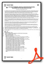

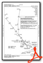
Standard Terminal Arrival (STAR) Charts

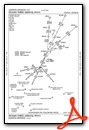

Instrument Approach Procedure (IAP) Charts


Nearby Airports with Instrument Procedures
| ID | Name | Heading / Distance | ||
|---|---|---|---|---|
 |
KWDR | Barrow County Airport | 088° | 14.7 |
|
D73 | Cy Nunnally Memorial Airport | 130° | 17.8 |
|
KPDK | Dekalb-Peachtree Airport | 250° | 18.0 |
|
KGVL | Lee Gilmer Memorial Airport | 020° | 18.8 |
|
KCVC | Covington Municipal Airport | 164° | 21.5 |
|
KJCA | Jackson County Airport | 059° | 23.2 |
|
KMGE | Dobbins Arb Airport | 262° | 27.8 |
|
KFTY | Fulton County Exec/Charlie Brown Field Airport | 247° | 30.4 |
|
KCNI | Cherokee County Regional Airport | 311° | 30.4 |
|
KATL | Hartsfield/Jackson Atlanta International Airport | 228° | 31.0 |
|
KRYY | Cobb County International/Mccollum Field Airport | 273° | 31.7 |
|
KAHN | Athens/Ben Epps Airport | 093° | 31.8 |
Fuel Providers


We proudly offer fuel from:

US Dollar per US Gallon
Price Guaranteed by FBO

Airport Images
Do you have a recent image of this airport? Upload it here!


