Login
Register


OLM
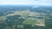
Olympia Regional Airport
Official FAA Data Effective 2025-12-25 0901Z
Chart Supplement

KOLM Airport Diagram

VFR Chart of KOLM
Sectional Charts at SkyVector.com
IFR Chart of KOLM
Enroute Charts at SkyVector.com
Location Information for KOLM
Coordinates: N46°58.16' / W122°54.15'Located 04 miles S of Olympia, Washington on 845 acres of land. View all Airports in Washington.
Estimated Elevation is 207 feet MSL.
Operations Data
|
|
Airport Communications
| ATIS: | 135.725 |
|---|---|
| ASOS: | Tel. 360-754-0781 |
| OLYMPIA TOWER: | 124.4 254.25 |
| OLYMPIA GROUND: | 121.6 |
| SEATTLE APPROACH: | 121.1 290.9 |
| SEATTLE DEPARTURE: | 121.1 290.9 |
| CTAF: | 124.400 |
| UNICOM: | 122.950 |
| ATIS at GRF (14.7 NE): | 124.65 |
| AWOS-3 at CLS (17.9 S): | 118.025 360-740-5164 |
| ASOS at SHN (18.8 NW): | 119.275 360-358-3006 |
- EMERG FREQ 121.5 NOT MON AT TOWER
Nearby Navigation Aids
|
| ||||||||||||||||||||||||||||||||||||

Runway 17/35
| Dimensions: | 5500 x 150 feet / 1676 x 46 meters | |
|---|---|---|
| Surface: | Asphalt / Grooved in Good Condition | |
| Weight Limits: | S-75, D-94, ST-142 | |
| Edge Lighting: | High Intensity | |
| Runway 17 | Runway 35 | |
| Coordinates: | N46°58.58' / W122°54.14' | N46°57.69' / W122°54.40' |
| Elevation: | 196.6 | 202.8 |
| Traffic Pattern: | Left | Right |
| Runway Heading: | 191° True | 11° True |
| Markings: | Precision Instrument in poor condition. | Non-Precision Instrument in poor condition. |
| Glide Slope Indicator | P4L (3.00° Glide Path Angle) | P4L (3.00° Glide Path Angle) |
| Approach Lights: | MALSR 1,400 Foot Medium-intensity Approach Lighting System with runway alignment indicator lights. | |
| REIL: | Yes | |
Runway 08/26
| Dimensions: | 4157 x 150 feet / 1267 x 46 meters | |
|---|---|---|
| Surface: | Asphalt in Good Condition | |
| Weight Limits: | S-30 | |
| Runway 08 | Runway 26 | |
| Coordinates: | N46°58.28' / W122°54.48' | N46°58.12' / W122°53.51' |
| Elevation: | 194.1 | 204.1 |
| Traffic Pattern: | Right | Left |
| Runway Heading: | 104° True | 284° True |
| Markings: | Basic in good condition. | Basic in good condition. |
| Obstacles: | 58 ft Trees 1360 ft from runway, 325 ft left of center | 107 ft Tree 950 ft from runway, 207 ft right of center |
Services Available
| Fuel: | 100LL (blue), Jet-A |
|---|---|
| Transient Storage: | Hangars,Tiedowns |
| Airframe Repair: | MAJOR |
| Engine Repair: | MAJOR |
| Bottled Oxygen: | NONE |
| Bulk Oxygen: | NONE |
| Other Services: | AIR AMBULANCE SERVICES,AVIONICS,CHARTER SERVICE,PILOT INSTRUCTION,AIRCRAFT RENTAL |
Ownership Information
| Ownership: | Publicly owned | |
|---|---|---|
| Owner: | PORT OF OLYMPIA | |
| 606 COLUMBIA ST NW, SUITE 300 | ||
| OLYMPIA, WA 98501-0827 | ||
| 360-528-8000 | ||
| Manager: | CHRIS PAOLINI | |
| 7643 OLD HWY 99 SE | ||
| OLYMPIA, WA 98501 | ||
| 360-528-8074 | ||
Other Remarks
- TWY LGTS ON TWY W, A, L, AND B.
- AIRPORT FIELD CONDITIONS UNMONITORED 1700 LCL - 0700 LCL.
- EMERG FREQ 121.5 NOT MNT AT TWR.
- FOR CD WHEN ATCT IS CLSD CTC SEATTLE APCH AT 206-214-4723.
- WHEN ATCT CLSD ACTVT HIRL RY 17/35; MALSR 17; REIL RY 35, TWY LGTS & DIRECTIONAL SIGNAGE - CTAF. PAPI RYS 17 & 35 OPER CONT.
Weather Minimums

Instrument Approach Procedure (IAP) Charts


Departure Procedure (DP) Charts

Nearby Airports with Instrument Procedures
| ID | Name | Heading / Distance | ||
|---|---|---|---|---|
 |
KGRF | Gray AAF (Joint Base Lewis-Mcchord) Airport | 063° | 14.8 |
|
KCLS | Chehalis-Centralia Airport | 190° | 17.9 |
|
KSHN | Sanderson Field Airport | 327° | 18.8 |
|
KTCM | Mcchord Field (Joint Base Lewis-Mcchord) Airport | 059° | 20.2 |
|
KTIW | Tacoma Narrows Airport | 036° | 22.3 |
|
KPLU | Pierce County/Thun Field Airport | 072° | 26.5 |
|
KTDO | Ed Carlson Memorial Field/South Lewis County Airport | 172° | 29.8 |
|
KPWT | Bremerton Ntl Airport | 010° | 31.8 |
|
S50 | Auburn Municipal Airport | 051° | 35.1 |
|
KSEA | Seattle-Tacoma International Airport | 039° | 37.6 |
|
KBFI | Boeing Field/King County International Airport | 035° | 41.7 |
|
KRNT | Renton Municipal Airport | 041° | 42.2 |