Login
Register


SHN
Sanderson Field Airport
Official FAA Data Effective 2026-01-22 0901Z
Chart Supplement

VFR Chart of KSHN
Sectional Charts at SkyVector.com
IFR Chart of KSHN
Enroute Charts at SkyVector.com
Location Information for KSHN
Coordinates: N47°14.01' / W123°8.85'Located 03 miles NW of Shelton, Washington on 1054 acres of land. View all Airports in Washington.
Surveyed Elevation is 272 feet MSL.
Operations Data
|
|
Airport Communications
| ASOS: | 119.275 Tel. 360-358-3006 |
|---|---|
| SEATTLE APPROACH: | 121.1 290.9 |
| SEATTLE DEPARTURE: | 121.1 290.9 |
| UNICOM: | 122.800 |
| CTAF: | 122.800 |
| ASOS at OLM (18.8 SE): | 360-754-0781 |
| ATIS at OLM (18.8 SE): | 135.725 |
| AWOS-3PT at PWT (22.2 NE): | 121.2 360-674-2811 |
Nearby Navigation Aids
|
| ||||||||||||||||||||||||||||||||||||||||||


Runway 05/23
| Dimensions: | 5005 x 100 feet / 1526 x 30 meters | |
|---|---|---|
| Surface: | Asphalt in Good Condition | |
| Weight Limits: | 17 /F/A/Y/T, S-55, D-72, ST-130 | |
| Edge Lighting: | Medium Intensity | |
| Runway 05 | Runway 23 | |
| Coordinates: | N47°13.86' / W123°9.41' | N47°14.17' / W123°8.29' |
| Elevation: | 258.6 | 272.9 |
| Traffic Pattern: | Right | Left |
| Runway Heading: | 68° True | 248° True |
| Markings: | Non-Precision Instrument in fair condition. | Non-Precision Instrument in fair condition. |
| Glide Slope Indicator | P4L (3.00° Glide Path Angle) | |
| REIL: | Yes | |
| Obstacles: | 49 ft Trees 1053 ft from runway, 141 ft right of center | 80 ft Trees 2298 ft from runway |
Services Available
| Fuel: | 100LL (blue), Jet-A |
|---|---|
| Transient Storage: | Tiedowns PILOTS BRING OWN ROPES. |
| Airframe Repair: | MAJOR |
| Engine Repair: | MAJOR |
| Bottled Oxygen: | NONE |
| Bulk Oxygen: | NONE |
| Other Services: | CHARTER SERVICE,PILOT INSTRUCTION,PARACHUTE JUMP ACTIVITY,AIRCRAFT RENTAL |
Ownership Information
| Ownership: | Publicly owned | |
|---|---|---|
| Owner: | PORT OF SHELTON | |
| 21 WEST SANDERSON WAY | ||
| SHELTON, WA 98584 | ||
| 360-426-1151 | ||
| Manager: | WENDY SMITH- EXECUTIVE DIRECTOR | |
| 21 WEST SANDERSON WAY | ||
| SHELTON, WA 98584 | ||
| 360-426-1151 | ||
Other Remarks
- (E94) SAWRS
- PARACHUTE OPERATIONS ON THE FIELD AVOID CROSSING MIDFIELD TO ENTER TRAFFIC PATTERN.
- FOR CD CTC SEATTLE APCH AT 206-214-4723.
- 0LL 24 HR CREDIT CARD FUEL FAC.
- ACTVT REIL RWY 23; PAPI RWY 23; MIRL RWY 05/23 - CTAF.
Weather Minimums

Instrument Approach Procedure (IAP) Charts
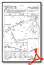
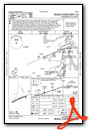
Nearby Airports with Instrument Procedures
| ID | Name | Heading / Distance | ||
|---|---|---|---|---|
 |
KOLM | Olympia Regional Airport | 147° | 18.8 |
|
KPWT | Bremerton Ntl Airport | 045° | 21.9 |
|
KTIW | Tacoma Narrows Airport | 084° | 23.4 |
|
KGRF | Gray AAF (Joint Base Lewis-Mcchord) Airport | 111° | 25.0 |
|
KTCM | Mcchord Field (Joint Base Lewis-Mcchord) Airport | 101° | 28.1 |
|
KCLS | Chehalis-Centralia Airport | 168° | 34.1 |
|
KHQM | Bowerman Field Airport | 244° | 36.0 |
|
KPLU | Pierce County/Thun Field Airport | 102° | 36.1 |
|
KSEA | Seattle-Tacoma International Airport | 068° | 36.5 |
|
S50 | Auburn Municipal Airport | 081° | 38.0 |
|
KBFI | Boeing Field/King County International Airport | 062° | 38.8 |
|
KRNT | Renton Municipal Airport | 067° | 41.1 |
Airport Images

By: Dave


