Login
Register


TVF
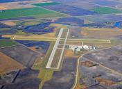
Thief River Falls Regional Airport
Official FAA Data Effective 2025-02-20 0901Z
Chart Supplement

KTVF Airport Diagram

VFR Chart of KTVF
Sectional Charts at SkyVector.com
IFR Chart of KTVF
Enroute Charts at SkyVector.com
Location Information for KTVF
Coordinates: N48°3.94' / W96°11.10'Located 03 miles S of Thief River Falls, Minnesota on 916 acres of land. View all Airports in Minnesota.
Surveyed Elevation is 1118 feet MSL.
Operations Data
|
|
Airport Communications
| AWOS-3PT: | 119.025 Tel. 218-681-1918 |
|---|---|
| CTAF: | 122.800 |
| UNICOM: | 122.800 |
| AWOS-3 at CKN (22.1 SW): | 126.425 218-281-3018 |
| AWOS-3 at FSE (32.9 SE): | 118.35 218-435-6448 |
| ATIS at GFK (40.4 W): | 119.4 |
- APCH/DEP SVC PRVDD BY MINNEAPOLIS ARTCC ON FREQS 132.15/269.6 (GRAND FORKS RCAG).
Nearby Navigation Aids
|
| ||||||||||||||||||||||||||||||||||||||||||||||||


Runway 13/31
| Dimensions: | 6504 x 150 feet / 1982 x 46 meters | |
|---|---|---|
| Surface: | Asphalt / Grooved in Good Condition | |
| Weight Limits: | S-83, D-106, ST-163
PCR VALUE: 340/F/D/X/T
| |
| Edge Lighting: | High Intensity | |
| Runway 13 | Runway 31 | |
| Coordinates: | N48°4.26' / W96°11.60' | N48°3.50' / W96°10.47' |
| Elevation: | 1114.8 | 1113.2 |
| Traffic Pattern: | Left | Left |
| Runway Heading: | 135° True | 315° True |
| Declared Distances: | TORA:6504 TODA:6504 ASDA:6504 LDA:6504 | TORA:6504 TODA:6504 ASDA:6304 LDA:6304 |
| Markings: | Precision Instrument in good condition. | Precision Instrument in good condition. |
| Glide Slope Indicator | P4L (3.00° Glide Path Angle) | P4L (3.00° Glide Path Angle) |
| Approach Lights: | MALSR 1,400 Foot Medium-intensity Approach Lighting System with runway alignment indicator lights. | |
| REIL: | Yes | |
Runway 04/22
CLSD TO SKEDD ACR OPS GTR THAN 9 PAX SEATS OR UNSKED ACR OPS GTR THAN 30 PAX SEATS. | ||
| Dimensions: | 4997 x 75 feet / 1523 x 23 meters | |
|---|---|---|
| Surface: | Asphalt / Grooved in Good Condition | |
| Weight Limits: | S-83, D-106, ST-163
PCR VALUE: 390/F/D/X/T
| |
| Edge Lighting: | Medium Intensity | |
| Runway 04 | Runway 22 | |
| Coordinates: | N48°3.70' / W96°11.57' | N48°4.34' / W96°10.80' |
| Elevation: | 1112.5 | 1118.3 |
| Runway Heading: | 39° True | 219° True |
| Declared Distances: | TORA:4997 TODA:4997 ASDA:4997 LDA:4997 | TORA:4997 TODA:4997 ASDA:4997 LDA:4997 |
| Markings: | Non-Precision Instrument in good condition. | Non-Precision Instrument in good condition. |
| Glide Slope Indicator | P4L (3.00° Glide Path Angle) | P4L (3.00° Glide Path Angle) |
| REIL: | Yes | Yes |
Services Available
| Fuel: | 100LL (blue), Jet-A, Jet A+ |
|---|---|
| Transient Storage: | Hangars,Tiedowns |
| Airframe Repair: | MAJOR |
| Engine Repair: | MAJOR |
| Bottled Oxygen: | NOT AVAILABLE |
| Bulk Oxygen: | NOT AVAILABLE |
| Other Services: | CROP DUSTING SERVICES |
Ownership Information
| Ownership: | Publicly owned | |
|---|---|---|
| Owner: | THIEF RIVER FALLS ARPT AUTH | |
| 13722 AIRPORT DR, PO BOX 672 | ||
| THIEF RIVER FALLS, MN 56701-0672 | ||
| 218-681-7680 | ||
| Manager: | JOSEPH HEDRICK | |
| THIEF RIVER FALLS ARPT AUTH, 13722 AIRPORT DR | ||
| THIEF RIVER FALLS, MN 56701-8497 | ||
| 218-684-1013 | ||
Other Remarks
- BIRDS ON & INVOF ARPT.
- ARPT CONDS NOT MNTD SUN-FRI 2200-0500; FRI 2200-SAT 0600; SAT 1030-1500; SAT 2000-SUN 0600.
- FOR CD IF UNA TO CTC ON FSS FREQ, CTC MINNEAPOLIS ARTCC AT 651-463-5588.
- LDG FEES FOR COML ACFT CALL AMGR 218-681-7680 OPTION 7.
- 0LL AVBL 24 HRS WITH CREDIT CARD.
- ACTVT MALSR RWY 31; REIL RWY 13, 04, & 22; HIRL RWY 13/31; MIRL RWY 04/22 - CTAF. PAPI RWY 13, 31, 04, & 22 OPR CONSLY.
Weather Minimums


Instrument Approach Procedure (IAP) Charts


Nearby Airports with Instrument Procedures
| ID | Name | Heading / Distance | ||
|---|---|---|---|---|
 |
KCKN | Crookston Municipal/Kirkwood Field Airport | 232° | 22.2 |
|
D37 | Warren Municipal Airport | 289° | 22.5 |
|
D14 | Fertile Municipal Airport | 188° | 31.2 |
|
KFSE | Fosston Municipal/Anderson Field Airport | 149° | 32.9 |
|
KGFK | Grand Forks International Airport | 260° | 40.5 |
|
D00 | Norman County Ada/Twin Valley Airport | 190° | 49.1 |
|
KRDR | Grand Forks AFB Airport | 263° | 49.4 |
|
3N8 | Mahnomen County Airport | 167° | 49.4 |
|
KHCO | Hallock Municipal Airport | 323° | 51.2 |
|
KROX | Roseau Municipal/Rudy Billberg Field Airport | 022° | 51.3 |
|
KGAF | Hutson Field Airport | 293° | 51.7 |
|
3H4 | Hillsboro Municipal Airport | 220° | 55.3 |