Login
Register


11A
Clayton Municipal Airport
Official FAA Data Effective 2026-02-19 0901Z
Chart Supplement

VFR Chart of 11A
Sectional Charts at SkyVector.com
IFR Chart of 11A
Enroute Charts at SkyVector.com
Location Information for 11A
Coordinates: N31°53.00' / W85°29.11'Located 02 miles W of Clayton, Alabama on 56 acres of land. View all Airports in Alabama.
Surveyed Elevation is 434 feet MSL.
Operations Data
|
|
Airport Communications
| AWOS-3: | 118.775 Tel. 334-775-8414 |
|---|---|
| CAIRNS APPROACH: | 121.1 319.25 |
| CAIRNS DEPARTURE: | 121.1 319.25 |
| CTAF: | 122.900 |
| ASOS at EUF (18.5 E): | 128.325 334-232-0003 |
| ASOS at TOI (27.0 W): | 334-566-3081 |
| ATIS at TOI (27.0 W): | 120.925 |
- APCH/DEP SVC PRVDD BY ATLANTA ARTCC ON FREQS 120.55/270.25 (MONTGOMERY RCAG) WHEN CAIRNS APCH/DEP CLSD.
Nearby Navigation Aids
|
| ||||||||||||||||||||||||||||||||||||||||||||||||||||||||||||


Runway 10/28
| Dimensions: | 5010 x 80 feet / 1527 x 24 meters | |
|---|---|---|
| Surface: | Asphalt / Aggregate Friction Seal Coated in Fair Condition | |
| Edge Lighting: | High Intensity | |
| Runway 10 | Runway 28 | |
| Coordinates: | N31°53.05' / W85°29.59' | N31°52.95' / W85°28.63' |
| Elevation: | 422.0 | 434.3 |
| Traffic Pattern: | Left | Left |
| Runway Heading: | 97° True | 277° True |
| Displaced Threshold: | 278 Feet | |
| Markings: | Non-Precision Instrument in fair condition. | Non-Precision Instrument in fair condition. |
| Glide Slope Indicator | P2L (3.20° Glide Path Angle) | P2L (3.75° Glide Path Angle) |
| REIL: | Yes | Yes |
| Obstacles: | 53 ft Tree 1106 ft from runway, 178 ft right of center APCH RATIO 19:1 FM DSPLCD THR. |
85 ft Tree 1203 ft from runway, 293 ft right of center |
Services Available
| Fuel: | NONE |
|---|---|
| Transient Storage: | Tiedowns |
| Airframe Repair: | NONE |
| Engine Repair: | NONE |
| Bottled Oxygen: | NONE |
| Bulk Oxygen: | NONE |
Ownership Information
| Ownership: | Publicly owned | |
|---|---|---|
| Owner: | CITY OF CLAYTON | |
| PO BOX 385 | ||
| CLAYTON, AL 36016 | ||
| 334-775-9176 | ||
| Manager: | DARRELL BYRD | |
| 25 ROBERTSON AIRPORT RD. | ||
| CLAYTON, AL 36016 | ||
| 334-232-1028 | ||
Other Remarks
- DEER AND BIRD ACTVTY ON AND INVOF RWY.
- FOR CD CTC CAIRNS APCH AT 334-255-8402; FOR CD WHEN CAIRNS APCH CLSD CTC ATLANTA ARTCC AT 770-210-7692.
- ACTVT PAPI RWY 10 & 28; REIL RWY 10 & 28; HIRL RWY 10/28 - CTAF.
Weather Minimums

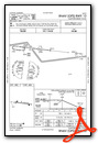
Instrument Approach Procedure (IAP) Charts

Nearby Airports with Instrument Procedures
| ID | Name | Heading / Distance | ||
|---|---|---|---|---|
 |
KEUF | Weedon Field Airport | 077° | 18.6 |
|
07A | Franklin Field Airport | 315° | 23.8 |
|
KTOI | Troy Municipal At N Kenneth Campbell Field Airport | 267° | 27.0 |
|
71J | Ozark/Blackwell Field Airport | 194° | 27.9 |
|
KHDL | Headland Municipal Airport | 164° | 32.3 |
|
KDHN | Dothan Regional Airport | 176° | 33.7 |
|
06A | Moton Field Municipal Airport | 344° | 36.0 |
|
KLSF | Lawson AAF (Fort Benning) Airport | 043° | 36.9 |
|
KOZR | Cairns AAF (Fort Rucker) Airport | 197° | 38.2 |
|
KEDN | Enterprise Municipal Airport | 211° | 40.9 |
|
KBIJ | Early County Airport | 133° | 42.0 |
|
KAUO | Auburn University Regional Airport | 003° | 43.9 |
Airport Images
Do you have a recent image of this airport? Upload it here!


