Login
Register


ADK
Adak Airport
Official FAA Data Effective 2025-12-25 0901Z
Chart Supplement

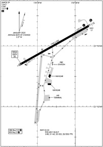
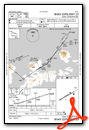
PADK Airport Diagram
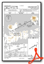
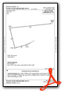
VFR Chart of PADK
Sectional Charts at SkyVector.com
IFR Chart of PADK
Enroute Charts at SkyVector.com
Location Information for PADK
Coordinates: N51°53.01' / W176°38.55'Located 00 miles W of Adak Island, Alaska. View all Airports in Alaska.
Surveyed Elevation is 19 feet MSL.
Operations Data
|
|
Airport Communications
| AWOS-3P: | 134.5 Tel. 907-621-7603 |
|---|---|
| CTAF: | 122.900 |
- APCH/DEP SVC PRVDD BY ANCHORAGE ARTCC ON FREQS 126.4/254.3 (ADAK RCAG).
Nearby Navigation Aids
|
| ||||||||||||||||||||||||||||||


Runway 05/23
| Dimensions: | 7790 x 200 feet / 2374 x 61 meters | |
|---|---|---|
| Surface: | Asphalt / Grooved in Good Condition | |
| Weight Limits: | S-80, D-145, ST-325, DT-770
PCR VALUE: 630/F/B/X/T
| |
| Edge Lighting: | High Intensity | |
| Runway 05 | Runway 23 | |
| Coordinates: | N51°52.70' / W176°39.45' | N51°53.33' / W176°37.65' |
| Elevation: | 19.5 | 16.9 |
| Traffic Pattern: | Right | |
| Runway Heading: | 61° True | 241° True |
| Displaced Threshold: | 600 Feet | |
| Declared Distances: | TORA:7790 TODA:7790 ASDA:6790 LDA:6190 | TORA:7790 TODA:7790 ASDA:6790 LDA:6790 |
| Markings: | Non-Precision Instrument in good condition. | Precision Instrument in good condition. |
| Glide Slope Indicator | P4R (3.50° Glide Path Angle) UNUSBL BYD 7 DEG RIGHT OF CNTRLN. | |
| RVR Equipment | Rollout | Touchdown |
| Approach Lights: | MALS 1,400 Foot Medium-intensity Approach Lighting System. NONSTD LEN 600 FT. | |
| REIL: | Yes | |
| Obstacles: | ft Hill ft from runway | |
Services Available
| Fuel: | Jet A-1 |
|---|---|
| Transient Storage: | NONE |
| Airframe Repair: | NOT AVAILABLE |
| Engine Repair: | NOT AVAILABLE |
| Bottled Oxygen: | NOT AVAILABLE |
| Bulk Oxygen: | NOT AVAILABLE |
| Other Services: | CARGO HANDLING SERVICES |
Ownership Information
| Ownership: | Publicly owned | |
|---|---|---|
| Owner: | ALASKA DOT&PF SOUTHCOAST REGION | |
| 1500 ANTON LARSON | ||
| KODIAK, AK 99615-2506 | ||
| 907-465-1784 | ||
| Manager: | INNOCENT DUSHKIN | |
| P O BOX 1952 | ||
| ADAK, AK 99546 | ||
| 907-592-8026 | AFT HR - 907-572-9900. | |
Other Remarks
- CTN: EXP WIND SHEAR.
- LOCK BRAKE TURNS NA.
- BIRDS INVOF ARPT.
- PAEW ON RWY.
- AFT HR HAZ RPRTG, SNOW & ICE REMOVAL PPR IN WRITING - AMGR.
- RCMND VISUAL INSP PRIOR TO USE.
- BE ALERT DURG APCH; MT TRRN ALL QUADS.
- ARPT CLSD OCT 01 - APR 30 TO NON SKED ACFT EXC 2 HR PPR - 907-572-9900.
- VOLCANO 5710 FT MSL 22.3 NM BRG 059 DEGS.
- FUEL SVC 0800-1700 - 907-592-8330. AFT HR PPR; SVC FEE AFT HR - 907-572-6070.
- ACTVT MALS RWY 23; REIL RWY 23; PAPI RWY 23; HIRL RWY 05/23 - CTAF.
Weather Minimums

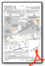
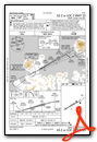
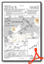
Instrument Approach Procedure (IAP) Charts
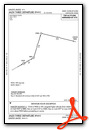
Departure Procedure (DP) Charts
Nearby Airports with Instrument Procedures
| ID | Name | Heading / Distance | ||
|---|---|---|---|---|
 |
PAAK | Atka Airport | 076° | 92.5 |
Airport Images
Do you have a recent image of this airport? Upload it here!


