Login
Register


AQT
Nuiqsut Airport
Official FAA Data Effective 2026-01-22 0901Z
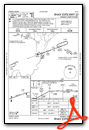
Chart Supplement

VFR Chart of PAQT
Sectional Charts at SkyVector.com
IFR Chart of PAQT
Enroute Charts at SkyVector.com
Location Information for PAQT
Coordinates: N70°12.59' / W151°0.39'Located 00 miles S of Nuiqsut, Alaska. View all Airports in Alaska.
Surveyed Elevation is 45 feet MSL.
Operations Data
|
|
Airport Communications
| ASOS: | 135.35 Tel. 907-480-5577 |
|---|---|
| CTAF: | 122.800 |
- APCH/DEP SVC PRVDD BY ANCHORAGE ARTCC ON FREQ 119.4 (NUIQSUT RCAG).
- COMMUNICATIONS PRVDD BY DEADHORSE FSS ON FREQ 122.5 (NUIQSUT RCO).
Nearby Navigation Aids
|
| ||||||||||||||||||

Runway 05/23
| Dimensions: | 4589 x 100 feet / 1399 x 30 meters | |
|---|---|---|
| Surface: | Gravel in Good Condition | |
| Edge Lighting: | Medium Intensity | |
| Runway 05 | Runway 23 | |
| Coordinates: | N70°12.46' / W151°1.43' | N70°12.72' / W150°59.35' |
| Elevation: | 44.2 | 37.5 |
| Traffic Pattern: | Right | |
| Runway Heading: | 70° True | 250° True |
| Markings: | in good condition. | in good condition. |
| Glide Slope Indicator | P2L (3.00° Glide Path Angle) | P2L (3.00° Glide Path Angle) |
| Approach Lights: | MALSF 1,400 Foot Medium-intensity Approach Lighting System with sequenced flashers. | |
| REIL: | Yes | |
Ownership Information
| Ownership: | Publicly owned | |
|---|---|---|
| Owner: | NORTH SLOPE BOROUGH | |
| BOX 69 | ||
| BARROW, AK 99723 | ||
| 907-852-2611 | ||
| Manager: | GEORGE AHMAOGAK | |
| BOX 69 | ||
| BARROW, AK 99723 | ||
| 907-852-0489 | EXT 342 | |
Other Remarks
- BIRDS & CARIBOU ON & INVOF ARPT.
- RWY COND UNMNT; RCMD VISUAL INSP PRIOR TO LNDG.
- DEADHORSE FSS LCL - 907 659-2401; FAIRBANKS FSS - 1-866-248-6516.
- WX CAMERA AVBL ON INTERNET AT HTTPS://WEATHERCAMS.FAA.GOV.
- 100 FT LGTD TWR 847 FT N OF THR.
- ACTVT MALSF RWY 05, REIL RWY 23; PAPI RWY 05, 23; MIRL RWY 05/23 - CTAF.
Weather Minimums


Instrument Approach Procedure (IAP) Charts

Nearby Airports with Instrument Procedures
| ID | Name | Heading / Distance | ||
|---|---|---|---|---|
 |
PAKU | Ugnu-Kuparuk Airport | 075° | 29.6 |
|
PASC | Deadhorse Airport | 089° | 51.9 |
Airport Images
Do you have a recent image of this airport? Upload it here!


