Login
Register


SCC
Deadhorse Airport
Official FAA Data Effective 2026-01-22 0901Z
Chart Supplement

VFR Chart of PASC
Sectional Charts at SkyVector.com
IFR Chart of PASC
Enroute Charts at SkyVector.com
Location Information for PASC
Coordinates: N70°11.69' / W148°27.91'Located 00 miles SE of Deadhorse, Alaska on 6506 acres of land. View all Airports in Alaska.
Surveyed Elevation is 67 feet MSL.
Operations Data
|
|
Airport Communications
| ASOS: | 118.4 Tel. 907-659-2591 |
|---|---|
| CTAF: | 123.600 |
| UNICOM: | 123.000 |
- APCH/DEP SVC PRVDD BY ANCHORAGE ARTCC ON FREQS 134.4/370.9 (DEADHORSE RCAG).
- AFIS FREQUENCY 118.4. OPERATES SAME HRS AS SCC FSS, 0600-2130.
- COMMUNICATIONS PRVDD BY DEADHORSE FSS ON FREQ 123.6 (CTAF).
Nearby Navigation Aids
|
| ||||||||||||||||||||||||


Runway 06/24
| Dimensions: | 6500 x 150 feet / 1981 x 46 meters | |
|---|---|---|
| Surface: | Asphalt / Grooved in Good Condition | |
| Weight Limits: | S-120, D-250, ST-550
PCR VALUE: 801/F/A/X/T
| |
| Edge Lighting: | High Intensity | |
| Runway 06 | Runway 24 | |
| Coordinates: | N70°11.55' / W148°29.43' | N70°11.82' / W148°26.39' |
| Elevation: | 66.9 | 60.7 |
| Traffic Pattern: | Right | Left |
| Runway Heading: | 75° True | 255° True |
| Declared Distances: | TORA:6500 TODA:6500 ASDA:6500 LDA:6500 | TORA:6500 TODA:6500 ASDA:6500 LDA:6500 |
| Markings: | Precision Instrument in good condition. | Precision Instrument in good condition. |
| Glide Slope Indicator | V4L (3.00° Glide Path Angle) | V4L (3.00° Glide Path Angle) |
| RVR Equipment | Touchdown | Touchdown |
| Approach Lights: | MALSR 1,400 Foot Medium-intensity Approach Lighting System with runway alignment indicator lights. | MALSR 1,400 Foot Medium-intensity Approach Lighting System with runway alignment indicator lights. |
| Centerline Lights: | Yes | Yes |
Services Available
| Fuel: | 100 (green), Jet-A |
|---|---|
| Transient Storage: | NONE |
| Airframe Repair: | NOT AVAILABLE |
| Engine Repair: | NOT AVAILABLE |
| Bottled Oxygen: | NOT AVAILABLE |
| Bulk Oxygen: | NOT AVAILABLE |
| Other Services: | CARGO HANDLING SERVICES |
Ownership Information
| Ownership: | Publicly owned | |
|---|---|---|
| Owner: | ALASKA DOT&PF NORTHERN REGION | |
| 2301 PEGER RD | ||
| FAIRBANKS, AK 99709 | ||
| 907-451-2200 | ||
| Manager: | TIM PARAULT | |
| POUCH 340002 | ||
| PRUDHOE BAY, AK 99734 | ||
| 907-328-7130 | ||
Other Remarks
- WATERFOWL INVOF ARPT; CARIBOU ON RWY & MOV AREAS.
- ARFF SVC PPR IN WRITING - AMGR.
- AVN CNTR PVT PPR - 907-538-3600.
- TSA REGULATED; SEE 49 CFR 1542. ALL GATES & DOORS MUST BE SECURED AT ALL TIMES. TSNT OR UNFAMILIAR PILOTS - AMGR FOR INFO.
- COLVILLE RAMP CLSD.
- WX OBS WHEN DEADHORSE FSS CLSD - 133.55 OR 907-659-2401.
- ARPT MAINT 0600-1830; AFT HR - AMGR.
- WX CAMERA AVBL ON INTERNET AT HTTPS://WEATHERCAMS.FAA.GOV
- 0600-1800 - 122.85 OR 907-659-6215.
- WHEN FSS CLSD ACVT MALSR RWY 06 & 24; HIRL RWY 06/24 - CTAF. HIRL RWY 06/24 PRESET LOW INTST; INCR INTST - CTAF.
Weather Minimums


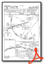
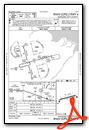
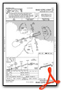
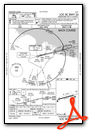
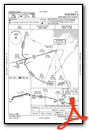
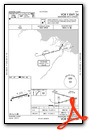
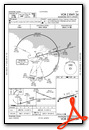
Instrument Approach Procedure (IAP) Charts
Nearby Airports with Instrument Procedures
| ID | Name | Heading / Distance | ||
|---|---|---|---|---|
 |
PAKU | Ugnu-Kuparuk Airport | 290° | 24.5 |
|
PAQT | Nuiqsut Airport | 272° | 51.9 |
Airport Images
Do you have a recent image of this airport? Upload it here!


