Login
Register


ARC
Arctic Village Airport
Official FAA Data Effective 2026-02-19 0901Z
Chart Supplement

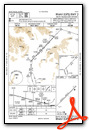
VFR Chart of PARC
Sectional Charts at SkyVector.com
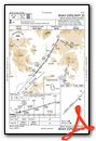
IFR Chart of PARC
Enroute Charts at SkyVector.com
Location Information for PARC
Coordinates: N68°6.88' / W145°34.76'Located 01 miles SW of Arctic Village, Alaska. View all Airports in Alaska.
Surveyed Elevation is 2092 feet MSL.
Operations Data
|
|
Airport Communications
| AWOS-3P: | 135.75 Tel. 907-269-2758 |
|---|---|
| CTAF: | 122.900 |
- APCH/DEP SVC PRVDD BY ANCHORAGE ARTCC ON FREQS 135.0/225.4 (FORT YUKON RCAG).
- COMMUNICATIONS PRVDD BY FAIRBANKS FSS ON FREQ 122.05 (FORT YUKON RCO).
Nearby Navigation Aids
|
| ||||||||||||
Runway 02/20
LINE OF SIGHT BTN RWY ENDS NA. | ||
| Dimensions: | 4500 x 75 feet / 1372 x 23 meters | |
|---|---|---|
| Surface: | Gravel in Poor Condition | |
| Edge Lighting: | Medium Intensity | |
| Runway 02 | Runway 20 | |
| Coordinates: | N68°6.62' / W145°35.46' | N68°7.14' / W145°34.07' |
| Elevation: | 2077.0 | 2092.0 |
| Traffic Pattern: | Left | Left |
| Runway Heading: | 45° True | 225° True |
| Glide Slope Indicator | P4L (3.00° Glide Path Angle) | |
| REIL: | Yes | |
| Obstacles: | 15 ft Road 337 ft from runway, 300 ft right of center | |
Ownership Information
| Ownership: | Publicly owned | |
|---|---|---|
| Owner: | VENETIE TRIBAL GOVN | |
| BOX 81080 | ||
| VENETIE, AK 97781 | ||
| 907-849-8165 | ||
| Manager: | JONATHAN JOHNS | |
| P.O. BOX 69 | ||
| ARCTIC VILLAGE, AK 99722 | ||
| 907-587-5523 | ||
Other Remarks
- RWY UNMNT RCMND VISUAL INSP PRIOR TO LDG.
- RWY SLPS DOWNHILL TO SW.
- WX CAMERA AVBL ON INTERNET AT HTTPS://WEATHERCAMS.FAA.GOV/.
- COLD TEMPERATURE AIRPORT. ALTITUDE CORRECTION REQUIRED AT OR BELOW -37C.
- DUSK-DAWN: ACTVT REIL RWY 20, PAPI RWY 20; MIRL RWY 02/20 - CTAF.
- DUSK-DAWN.
Weather Minimums

Instrument Approach Procedure (IAP) Charts
Departure Procedure Obstacles (DPO) Charts

Nearby Airports with Instrument Procedures
| ID | Name | Heading / Distance | ||
|---|---|---|---|---|
 |
PAVE | Venetie Airport | 195° | 69.0 |
|
PFYU | Fort Yukon Airport | 175° | 93.2 |
|
PACI | Chalkyitsik Airport | 153° | 98.2 |
|
PAWB | Beaver Airport | 202° | 113.8 |
|
PABA | Barter Island Airport | 018° | 127.3 |
Airport Images
Do you have a recent image of this airport? Upload it here!


