Login
Register


FYU
Fort Yukon Airport
Official FAA Data Effective 2026-02-19 0901Z
Chart Supplement

VFR Chart of PFYU
Sectional Charts at SkyVector.com
IFR Chart of PFYU
Enroute Charts at SkyVector.com
Location Information for PFYU
Coordinates: N66°34.35' / W145°14.78'Located 00 miles N of Fort Yukon, Alaska on 261 acres of land. View all Airports in Alaska.
Surveyed Elevation is 447 feet MSL.
Operations Data
|
|
Airport Communications
| AWOS-3P: | 125.8 Tel. 907-662-2337 |
|---|---|
| CTAF: | 122.500 |
- APCH/DEP SVC PRVDD BY ANCHORAGE ARTCC ON FREQS 135.0/225.4 (FORT YUKON RCAG).
- COMMUNICATIONS PRVDD BY FAIRBANKS FSS ON FREQ 122.05 (FORT YUKON RCO).
Nearby Navigation Aids
|
| ||||||||||||||||||

Runway 04/22
| Dimensions: | 5000 x 100 feet / 1524 x 30 meters | |
|---|---|---|
| Surface: | Gravel-Dirt in Good Condition | |
| Edge Lighting: | Medium Intensity | |
| Runway 04 | Runway 22 | |
| Coordinates: | N66°34.14' / W145°15.67' | N66°34.55' / W145°13.88' |
| Elevation: | 447.2 | 447.1 |
| Runway Heading: | 60° True | 240° True |
| Markings: | in good condition. | in good condition. |
| Glide Slope Indicator | V4L (3.00° Glide Path Angle) | V4L (3.00° Glide Path Angle) |
| Approach Lights: | MALSF 1,400 Foot Medium-intensity Approach Lighting System with sequenced flashers. | |
| Obstacles: | 4 ft Brush 0 ft from runway, 174 ft left of center | 2 ft Brush 0 ft from runway, 225 ft left of center |
Services Available
| Fuel: | Jet-A |
|---|---|
| Transient Storage: | NONE |
| Airframe Repair: | NOT AVAILABLE |
| Engine Repair: | NOT AVAILABLE |
| Bottled Oxygen: | NOT AVAILABLE |
| Bulk Oxygen: | NOT AVAILABLE |
Ownership Information
| Ownership: | Publicly owned | |
|---|---|---|
| Owner: | ALASKA DOT&PF NORTHERN REGION | |
| 2301 PEGER RD | ||
| FAIRBANKS, AK 99709 | ||
| 907-451-5280 | ||
| Manager: | JASON LUDINGTON | |
| 2301 PEGER RD | ||
| FAIRBANKS, AK 99709 | ||
| 907-451-5280 | ||
Other Remarks
- FLOAT PLANE OPS DO NOT CROSS RWY 04/22. TFC PAT FOR HOSPITAL LAKE RMN NW OF ARPT.
- WX CAMERA AVBL ON INTERNET AT HTTPS://WEATHERCAMS.FAA.GOV
- TWY C REFLECTORS 36 IN; UNLGT; CLSD DURG WINTER.
- LINE OF SIGHT BTN RWY THRS & WATERLANE NA; MON CTAF SPCLY BFR DEP.
- SNOW REMOVAL OPS MNT CTAF.
- RWY COND UNMNT; RCMD VISUAL INSP BFR LNDG.
- SUAIS - 125.3/126.3/1-800-758-8723.
- WX OBS CALLSIGN FORT YUKON WX - CTAF OR 907-662-2948 FM 0700-1900.
- BIRDS INVOF LANDFILL 1/4 MI NW OF RWY.
- DEP COMMENCE AT DTHR.
- JET A FUEL AVBL MAY - SEP : 907-662-2408.
- ACTVT MALSF RWY 22; VASI RWY 04 & 22; MIRL RWY 04/22 - CTAF.
Weather Minimums

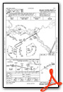
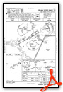
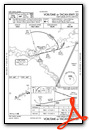
Instrument Approach Procedure (IAP) Charts
Nearby Airports with Instrument Procedures
| ID | Name | Heading / Distance | ||
|---|---|---|---|---|
 |
PACI | Chalkyitsik Airport | 082° | 36.3 |
|
PAVE | Venetie Airport | 315° | 37.4 |
|
PAWB | Beaver Airport | 257° | 53.5 |
|
PACE | Central Airport | 169° | 61.2 |
|
PARC | Arctic Village Airport | 355° | 93.2 |
|
PAEI | Eielson AFB Airport | 202° | 123.7 |
|
PAFA | Fairbanks International Airport | 212° | 124.0 |
Airport Images
Do you have a recent image of this airport? Upload it here!


