Login
Register


CDB
Cold Bay Airport
Official FAA Data Effective 2026-01-22 0901Z
Chart Supplement

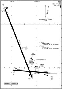
PACD Airport Diagram
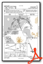
VFR Chart of PACD
Sectional Charts at SkyVector.com
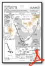
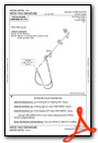
IFR Chart of PACD
Enroute Charts at SkyVector.com
Location Information for PACD
Coordinates: N55°12.36' / W162°43.57'Located 00 miles N of Cold Bay, Alaska on 2213 acres of land. View all Airports in Alaska.
Surveyed Elevation is 99 feet MSL.
Operations Data
|
|
Airport Communications
| ASOS: | 135.75 Tel. 907-532-2639 |
|---|---|
| CTAF: | 123.600 |
| AWOS-3P at KVC (16.6 E): | 118.325 907-497-4279 |
| AWOS-3P at KFP (31.8 SW): | 121.45 907-548-2221 |
| AWOS-3P at OUL (71.7 NE): | 119.025 907-989-2227 |
- APCH/DEP SVC PRVDD BY ANCHORAGE ARTCC ON FREQS 118.5/278.3 (COLD BAY RCAG).
- COMMUNICATIONS PRVDD BY COLD BAY FSS ON FREQ 123.6 (CTAF).
Nearby Navigation Aids
|
| ||||||||||||||||||||||||


Runway 15/33
| Dimensions: | 10179 x 150 feet / 3103 x 46 meters | |
|---|---|---|
| Surface: | Asphalt / Grooved in Good Condition | |
| Weight Limits: | S-120, D-246, ST-433, DT-970
PCR VALUE: 620/F/B/X/T
| |
| Edge Lighting: | High Intensity | |
| Runway 15 | Runway 33 | |
| Coordinates: | N55°13.34' / W162°44.27' | N55°11.79' / W162°43.20' |
| Elevation: | 72.5 | 93.3 |
| Traffic Pattern: | Left | Right |
| Runway Heading: | 158° True | 338° True |
| Declared Distances: | TORA:10179 TODA:10179 ASDA:10179 LDA:10179 | TORA:10179 TODA:10179 ASDA:10179 LDA:10179 |
| Markings: | Precision Instrument in good condition. | Non-Precision Instrument in good condition. |
| Glide Slope Indicator | P4L (3.00° Glide Path Angle) | |
| RVR Equipment | Touchdown | Rollout |
| Approach Lights: | MALSR 1,400 Foot Medium-intensity Approach Lighting System with runway alignment indicator lights. | |
Runway 08/26
| Dimensions: | 4900 x 150 feet / 1494 x 46 meters | |
|---|---|---|
| Surface: | Asphalt / Grooved in Good Condition | |
| Weight Limits: | S-120, D-250, ST-431, DT-966
PCR VALUE: 620/F/B/X/T
| |
| Edge Lighting: | High Intensity | |
| Runway 08 | Runway 26 | |
| Coordinates: | N55°11.95' / W162°43.95' | N55°11.89' / W162°42.54' |
| Elevation: | 88.9 | 99.5 |
| Traffic Pattern: | Left | Right |
| Runway Heading: | 95° True | 275° True |
| Declared Distances: | TORA:4900 TODA:4900 ASDA:4900 LDA:4900 | TORA:4900 TODA:4900 ASDA:4900 LDA:4900 |
| Markings: | Non-Precision Instrument in good condition. | Non-Precision Instrument in good condition. |
| Glide Slope Indicator | P4L (3.50° Glide Path Angle) UNUSBL BYD 5 DEGS RIGHT OF CNTRLN. | P4L (3.00° Glide Path Angle) |
Services Available
| Fuel: | 100LL (blue), Jet-A |
|---|---|
| Transient Storage: | Tiedowns |
| Airframe Repair: | NOT AVAILABLE |
| Engine Repair: | NOT AVAILABLE |
| Bottled Oxygen: | NOT AVAILABLE |
| Bulk Oxygen: | NOT AVAILABLE |
| Other Services: | CARGO HANDLING SERVICES |
Ownership Information
| Ownership: | Publicly owned | |
|---|---|---|
| Owner: | ALASKA DOT&PF SOUTHCOAST REGION | |
| P.O BOX 112506 | ||
| JUNEAU, AK 99811-2506 | ||
| 907-465-1763 | ||
| Manager: | HAROLD KREMER | |
| BOX 97 | ||
| COLD BAY, AK 99571 | ||
| 907-532-5000 | ||
Other Remarks
- SNOW, ICE REMOVAL & ARPT HAZ RPRTG DURG DUTY HR UNLESS PRIOR ARNGMT IN WRITING - AMGR.
- PAEW ON RWYS.
- ARPT SAND LRGR GRADE THAN FAA RCMDD/SEE AC150/5200-30.
- WX CAMERA AVBL - HTTPS://WEATHERCAMS.FAA.GOV
- DEICING & FUEL M-F 0800-1700 - 907-532-2467; AFT HR PPR & FEE - 907-532-7055.
- BIRDS INVOF ARPT.
- LOCKED WHEEL NA.
- CUST UNAVBL. FOREIGN RFLG ARR 24-48 HR WRITTEN PPR - FAX 907-271-2684 OR 907-271-2686.
- UNLGTD TWR 0.4 NM N, 0.9 NM S & 4.8 NM NW.
- ATCVT MALSR RWY 15; PAPI RWY 08, 26 & 33; HIRL RWY 08/26 & 15/33 - CTAF.
- PHOTOCELL OPS.
Weather Minimums


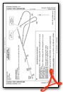
Instrument Approach Procedure (IAP) Charts


Nearby Airports with Instrument Procedures
| ID | Name | Heading / Distance | ||
|---|---|---|---|---|
 |
PAVC | King Cove Airport | 108° | 16.7 |
|
PAOU | Nelson Lagoon Airport | 047° | 71.8 |
|
PASD | Sand Point Airport | 084° | 76.0 |
|
PAUT | Akutan Airport | 238° | 118.8 |


