Login
Register


CDV
Merle K (Mudhole) Smith Airport
Official FAA Data Effective 2026-01-22 0901Z
Chart Supplement

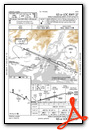
PACV Airport Diagram

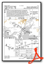
VFR Chart of PACV
Sectional Charts at SkyVector.com
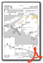
IFR Chart of PACV
Enroute Charts at SkyVector.com
Location Information for PACV
Coordinates: N60°29.50' / W145°28.65'Located 11 miles SE of Cordova, Alaska on 2959 acres of land. View all Airports in Alaska.
Surveyed Elevation is 53 feet MSL.
Operations Data
|
|
Airport Communications
| ASOS: | 134.8 Tel. 907-424-5900 |
|---|---|
| CTAF: | 123.600 |
| AWOS-3P at VDZ (44.6 NW): | 118.8 907-560-7614 |
- APCH/DEP SVC PRVDD BY ANCHORAGE ARTCC ON FREQ 133.6/269.4 (MIDDLETON ISLAND RCAG) AND 119.3 (JOHNSTONE POINT RCAG).
- COMMUNICATIONS PRVDD BY JUNEAU FSS ON FREQS 122.2 & 123.6 (CORDOVA RCO).
Nearby Navigation Aids
|
| ||||||||||||||||||||||||||||||||||||


Runway 09/27
| Dimensions: | 7500 x 150 feet / 2286 x 46 meters | |
|---|---|---|
| Surface: | Asphalt / Grooved in Good Condition | |
| Weight Limits: | S-90, D-153, ST-280
PCR VALUE: 977/F/A/X/T
| |
| Edge Lighting: | High Intensity | |
| Runway 09 | Runway 27 | |
| Coordinates: | N60°29.80' / W145°29.80' | N60°29.30' / W145°27.53' |
| Elevation: | 41.6 | 43.0 |
| Traffic Pattern: | Right | Left |
| Runway Heading: | 114° True | 294° True |
| Declared Distances: | TORA:7500 TODA:7500 ASDA:7500 LDA:7500 | TORA:7500 TODA:7500 ASDA:7500 LDA:7500 |
| Markings: | Precision Instrument in fair condition. | Precision Instrument in fair condition. |
| Glide Slope Indicator | V4L (3.00° Glide Path Angle) RWY 09 VASI UNUSBL BYD 4 NM DUE TO OBSTS. | V4L (3.00° Glide Path Angle) |
| RVR Equipment | Touchdown Rollout | Touchdown Rollout |
| Approach Lights: | ODALS Omnidirectional Approach Lighting System | MALSR 1,400 Foot Medium-intensity Approach Lighting System with runway alignment indicator lights. |
| Obstacles: | 20 ft Antenna 600 ft from runway, 250 ft left of center | 25 ft Pole 500 ft from runway, 450 ft right of center |
Runway 16/34
RWY 16/34 NOT AVBL FOR PART 121/380 SKED AND NON-SKED OPS WITH PAX CARRYING OPS MORE THAN 30 PAX SEATS. | ||
| Dimensions: | 1934 x 30 feet / 589 x 9 meters | |
|---|---|---|
| Surface: | Gravel in Fair Condition | |
| Runway 16 | Runway 34 | |
| Coordinates: | N60°29.46' / W145°28.60' | N60°29.14' / W145°28.60' |
| Elevation: | 49.5 | 38.6 |
| Traffic Pattern: | Left | Left |
| Runway Heading: | 181° True | 1° True |
| Markings: | None in poor condition. | None in poor condition. |
| Obstacles: | 70 ft Trees 350 ft from runway, 150 ft left of center | |
Services Available
| Fuel: | NONE |
|---|---|
| Transient Storage: | Tiedowns |
| Airframe Repair: | NOT AVAILABLE |
| Engine Repair: | NOT AVAILABLE |
| Bottled Oxygen: | NOT AVAILABLE |
| Bulk Oxygen: | NOT AVAILABLE |
| Other Services: | CARGO HANDLING SERVICES |
Ownership Information
| Ownership: | Publicly owned | |
|---|---|---|
| Owner: | ALASKA DOT&PF NORTHERN REGION | |
| 2301 PEGER ROAD | ||
| FAIRBANKS, AK 99709 | ||
| 907-451-2200 | ||
| Manager: | MATTHEW MYSZKA | |
| BOX 598 | ||
| CORDOVA, AK 99574 | ||
| 907-424-3202 | ||
Other Remarks
- ERRATIC WINDS.
- ARPT SAND LRGR GRADATION THAN FAA RCMDD/SEE AC150/5200-30.
- WX CAMERA AVBL ON INTERNET AT HTTPS://WEATHERCAMS.FAA.GOV
- TSA REGULATED ARPT; SEE 49 CFR 1542. GATES & DOORS MUST BE SECURED ALL TIMES; INFO - AMGR.
- ARPT SVCS & COND RPTG AVBL ONLY DURG MAINT DUTY HR; AFT HR - AMGR. BTN 1600 & 0700 SNOW REMOVAL & DEICE NA. RWY COND RPT REFLECTS DAY OPS ONLY.
- MOOSE & BIRDS INVOF ARPT & RWYS.
- ARFF EQUIP DURG ACR ACT ONLY.
- CORDOVA WX - 424-7614 OR 122.65.
- 36 IN ORANGE CONES MAY 1 - OCT 25.
- 36 IN ORANGE CONES MAY 1 - OCT 25.
- ACTVT MALSR RWY 27; ODALS RWY 09; VASI RWYS 09 & 27; HIRL RWY 09/27 - CTAF.
- ENGINEERED MATERIALS ARRESTING SYSTEM (EMAS) 250 FT IN LENGTH BY 170 FT IN WIDTH LCTD DER 27.
Weather Minimums


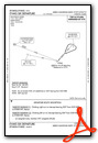
Instrument Approach Procedure (IAP) Charts
Departure Procedure (DP) Charts

Nearby Airports with Instrument Procedures
| ID | Name | Heading / Distance | ||
|---|---|---|---|---|
 |
PAKA | Tatitlek Airport | 303° | 42.5 |
|
PAVD | Valdez Pioneer Field Airport | 330° | 44.8 |
|
PAMD | Middleton Island Airport | 202° | 67.5 |
|
PAGK | Gulkana Airport | 000° | 100.0 |
Airport Images

By: Priam


