Login
Register


CXF
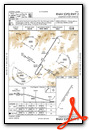
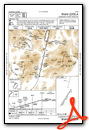
Coldfoot Airport
Official FAA Data Effective 2025-12-25 0901Z
Chart Supplement

VFR Chart of PACX
Sectional Charts at SkyVector.com
IFR Chart of PACX
Enroute Charts at SkyVector.com
Location Information for PACX
Coordinates: N67°15.13' / W150°12.23'Located 00 miles WSW of Coldfoot, Alaska on 288 acres of land. View all Airports in Alaska.
Surveyed Elevation is 1049 feet MSL.
Operations Data
|
|
Airport Communications
| AWOS-3P: | 118.0 Tel. 907-269-2771 |
|---|---|
| CTAF: | 122.900 |
| ASOS at BTT (36.7 SW): | 135.45 907-692-5900 |
| AWOS-3P at AKP (63.5 NW): | 135.75 907-661-3020 |
- APCH/DEP SVC PRVDD BY ANCHORAGE ARTCC ON FREQS 124.6/352.0 (BETTLES RCAG).
- COMMUNICATIONS PRVDD BY FAIRBANKS FSS ON FREQ 122.0 (COLDFOOT RCO).
Nearby Navigation Aids
|
| ||||||||||||||||||

Runway 02/20
| Dimensions: | 4011 x 75 feet / 1223 x 23 meters | |
|---|---|---|
| Surface: | Gravel in Good Condition | |
| Edge Lighting: | Medium Intensity | |
| Runway 02 | Runway 20 | |
| Coordinates: | N67°14.85' / W150°12.69' | N67°15.41' / W150°11.78' |
| Elevation: | 1034.4 | 1049.1 |
| Traffic Pattern: | Left | Left |
| Runway Heading: | 32° True | 212° True |
| Markings: | in fair condition. | in fair condition. |
| Obstacles: | 4 ft Brush 0 ft from runway, 155 ft right of center | 67 ft Trees 865 ft from runway, 65 ft left of center |
Services Available
| Fuel: | NONE |
|---|---|
| Transient Storage: | Tiedowns |
| Airframe Repair: | NONE |
| Engine Repair: | NONE |
| Bottled Oxygen: | NONE |
| Bulk Oxygen: | NONE |
Ownership Information
| Ownership: | Publicly owned | |
|---|---|---|
| Owner: | ALASKA DOT&PF NORTHERN REGION | |
| 2301 PEGER RD | ||
| FAIRBANKS, AK 99709 | ||
| 907-451-2200 | ||
| Manager: | JEFF RUSSELL | |
| 2301 PEGER RD | ||
| FAIRBANKS, AK 99709 | ||
| 907-451-2207 | ||
Other Remarks
- RY COND NOT MONITORED; RECOMMEND VISUAL INSPECTION PRIOR TO USING.
- WX CAMERA AVBL ON INTERNET AT HTTPS://WEATHERCAMS.FAA.GOV
- COLD TEMPERATURE AIRPORT. ALTITUDE CORRECTION REQUIRED AT OR BELOW -18C.
- ACTVT MIRL RY 02/20 & TWY LGTS - CTAF.
Weather Minimums

Instrument Approach Procedure (IAP) Charts
Departure Procedure Obstacles (DPO) Charts
Nearby Airports with Instrument Procedures
| ID | Name | Heading / Distance | ||
|---|---|---|---|---|
 |
PABT | Bettles Airport | 237° | 37.2 |
|
PAKP | Anaktuvuk Pass Airport | 327° | 63.7 |
|
PFAL | Allakaket Airport | 234° | 71.0 |
|
PAWB | Beaver Airport | 127° | 85.3 |
Airport Images
Do you have a recent image of this airport? Upload it here!


