Login
Register


BTT
Bettles Airport
Official FAA Data Effective 2026-02-19 0901Z
Chart Supplement

VFR Chart of PABT
Sectional Charts at SkyVector.com
IFR Chart of PABT
Enroute Charts at SkyVector.com
Location Information for PABT
Coordinates: N66°54.84' / W151°31.74'Located 00 miles N of Bettles, Alaska on 1195 acres of land. View all Airports in Alaska.
Surveyed Elevation is 647 feet MSL.
Operations Data
|
|
Airport Communications
| ASOS: | 135.45 Tel. 907-692-5900 |
|---|---|
| CTAF: | 122.900 |
| AWOS-3P at CXF (37.1 NE): | 118.0 907-269-2771 |
- APCH/DEP SVC PRVDD BY ANCHORAGE ARTCC ON FREQS 124.6/352.0 (BETTLES RCAG).
- COMMUNICATIONS PRVDD BY FAIRBANKS FSS ON FREQ 122.2 (BETTLES RCO).
Nearby Navigation Aids
|
| ||||||||||||||||||||||||


Runway 02/20
| Dimensions: | 5190 x 150 feet / 1582 x 46 meters | |
|---|---|---|
| Surface: | Gravel in Good Condition | |
| Edge Lighting: | Medium Intensity | |
| Runway 02 | Runway 20 | |
| Coordinates: | N66°54.48' / W151°32.32' | N66°55.20' / W151°31.16' |
| Elevation: | 635.2 | 647.3 |
| Traffic Pattern: | Left | Left |
| Runway Heading: | 32° True | 212° True |
| Glide Slope Indicator | V4L (3.00° Glide Path Angle) | V4L (3.00° Glide Path Angle) |
| Approach Lights: | MALS 1,400 Foot Medium-intensity Approach Lighting System. | |
| Obstacles: | 15 ft Road 0 ft from runway, 80 ft right of center | 15 ft Road 0 ft from runway, 80 ft right of center |
Runway 14W/32W
| Dimensions: | 4100 x 200 feet / 1250 x 61 meters | |
|---|---|---|
| Surface: | Water | |
| Runway 14W | Runway 32W | |
| Coordinates: | N66°53.58' / W151°29.82' | N66°52.92' / W151°29.48' |
| Elevation: | 649.4 | 649.4 |
Services Available
| Fuel: | 100LL (blue), Jet A-1+ |
|---|---|
| Transient Storage: | Tiedowns |
| Airframe Repair: | NOT AVAILABLE |
| Engine Repair: | NOT AVAILABLE |
| Bottled Oxygen: | NOT AVAILABLE |
| Bulk Oxygen: | NOT AVAILABLE |
Ownership Information
| Ownership: | Publicly owned | |
|---|---|---|
| Owner: | ALASKA DOT&PF NORTHERN REGION | |
| 2301 PEGER RD | ||
| FAIRBANKS, AK 99709 | ||
| (907) 451-5280 | ||
| Manager: | JASON LUDINGTON | |
| 2301 PEGER RD | ||
| FAIRBANKS, AK 99709 | ||
| (907) 451-5280 | ||
Other Remarks
- COLD TEMPERATURE AIRPORT. ALTITUDE CORRECTION REQUIRED AT OR BELOW -44C.
- FLOAT PLANE OPS 2 MI SE.
- FUEL H24; UNLEADED AVBL - 121.7/130.1/907-692-5111/907-692-5444.
- WINTER SNOW REMOVAL - CTAF.
- WX OBS AVBL - BETTLES WX ON CTAF OR 907-692-5533.
- RWY COND UNMNT; RCMD VISUAL INSP PRIOR TO LNDG.
- WX CAMERA AVBL ON INTERNET AT HTTPS://WEATHERCAMS.FAA.GOV
- ACTVT MALS RWY 02; VASI RWY 02 & 20; MIRL RWY 02/20 - CTAF.
- ACTVT SR-SS - CTAF.
Weather Minimums

Instrument Approach Procedure (IAP) Charts


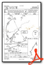
Nearby Airports with Instrument Procedures
| ID | Name | Heading / Distance | ||
|---|---|---|---|---|
 |
PFAL | Allakaket Airport | 230° | 34.0 |
|
PACX | Coldfoot Airport | 056° | 37.2 |
|
PAKP | Anaktuvuk Pass Airport | 356° | 73.6 |
|
PAHU | Hughes Airport | 232° | 84.3 |
|
PATA | Ralph M Calhoun Memorial Airport | 187° | 105.7 |
|
PAML | Manley Hot Springs Airport | 169° | 118.0 |
Airport Images

By: busterscv


