Login
Register


CYAL
Alert Bay Airport
VFR Chart of CYAL
Sectional Charts at SkyVector.com
IFR Chart of CYAL
Enroute Charts at SkyVector.com
Location Information for CYAL
Coordinates: N50°34.93' / W126°54.95'View all Airports in British Columbia, Canada.
Elevation is 240 feet MSL.
Magnetic Variation from 2016 is 17° East
Time Zone is UTC-8(7).
Operations Data
|
|
Airport Communications
| Aerodrome Traffic Frequency (ATF) | traffic 122.8 2NM 1600 ASL |
|---|
Nearby Navigation Aids
|
| ||||||||||||||||||||||||||||||||||||||||||


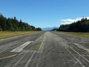
Runway 09/27
| Dimensions: | 2985 x 75 feet. | |
|---|---|---|
| Surface: | ||
| Remarks | ASPH | |
| Runway 09 | Runway 27 | |
| Runway Heading: | 094° | 274° |
Runway Conditions Reporting Source
Operator
Services Available
| Servicing Available | Extended Parking, Tie Downs |
|---|
Public Facilities
| Location | Facilities | Remarks |
|---|---|---|
| On Aerodrome | Telephone | |
| Within 5 NM | Food, Taxi, Medical Aid, Accomodations |
Flight Planning
| Flight Information Centre (FIC) | Kamloops 866-WXBRIEF (Toll free within Canada) or 866-541-4101 (Toll free within Canada & USA) |
|---|---|
| Weather (WX) | WxCam |
Aerodrome Operator
Corp of the village of Alert Bay
250-974-5213 Reg
Nearby Airports with Instrument Procedures
| ID | Name | Heading / Distance | ||
|---|---|---|---|---|
 |
CYZT | Port Hardy Airport | 272° | 18.2 |
|
CYBL | Campbell River Airport | 103° | 73.7 |
|
CYQQ | Comox Airport | 105° | 94.2 |
|
CYAZ | Tofino/Long Beach Airport | 136° | 100.4 |
|
CBBC | Bella Bella (Campbell Island) Airport | 317° | 107.0 |
Airport Images

By: Sinclair51
By: Sinclair51


