Login
Register


DAB
Daytona Beach International Airport
Official FAA Data Effective 2026-01-22 0901Z
From the Flight Deck
Chart Supplement

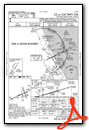
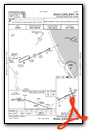
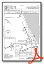
KDAB Airport Diagram

VFR Chart of KDAB
Sectional Charts at SkyVector.com
IFR Chart of KDAB
Enroute Charts at SkyVector.com
Location Information for KDAB
Coordinates: N29°10.79' / W81°3.48'Located 03 miles SW of Daytona Beach, Florida on 1800 acres of land. View all Airports in Florida.
Surveyed Elevation is 34 feet MSL.
TPA FOR LGT ACFT 965 FT AGL; TPA FOR HI PER ACFT 1365 FT AGL.
Operations Data
|
|
Airport Communications
| ATIS: | 132.875 |
|---|---|
| ASOS: | Tel. 386-232-5134 |
| DAYTONA TOWER: | 120.7 257.8 |
| DAYTONA GROUND: | 121.9 348.6 |
| DAYTONA APPROACH: | 118.85 ;N 4000-7500 125.35 ;S 3500 FT & BLW 125.725 ;8000-11000 FT 125.8 ;N 3500 FT & BLW 127.075 ;S 4000-7500 269.075 ;N 3500 FT & BLW 322.3 ;S 3500 FT & BLW 351.95 ;S 4000-8500 351.95 ;S 4000-8500 353.825 ;N 4000-8500 379.95 ;9000 FT & ABV |
| DAYTONA DEPARTURE: | 319.15 351.95 ;S 4000-8500 |
| IC: | 125.8 ;N 3500 FT & BLW 269.075 ;N 3500 FT & BLW 379.95 ;9000 FT & ABV |
| CLEARANCE DELIVERY: | 119.3 |
| CLASS C: | 125.35 ;S 3500 FT & BLW 125.8 ;N 3500 FT & BLW 269.075 ;N 3500 FT & BLW 322.3 ;S 3500 FT & BLW |
| TTHOR STAR: | 118.85 353.825 |
| UNICOM: | 122.950 |
| LAMMA DP: | 118.85 353.825 |
| EMERG: | 121.5 243.0 |
| ROYES DP: | 118.85 353.825 |
| AWOS-3 at OMN (7.8 N): | 118.475 386-615-7084 |
| ATIS at OMN (7.8 N): | 118.475 |
| AWOS-3 at EVB (9.3 SE): | 124.625 386-409-4705 |
- SAID IN USE. OPERATE TRANSPONDERS WITH ALTITUDE REPORTING MODE AND ADS-B (IF EQUIPPED) ENABLED ON ALL AIRPORT SURFACES.
Nearby Navigation Aids
|
| ||||||||||||||||||||||||||||||||||||||||||


Runway 07L/25R
| Dimensions: | 10500 x 150 feet / 3200 x 46 meters FIRST 2300 FT RWY 7L CONCRETE ON 50 FT WIDE KEEL SECTION. | |
|---|---|---|
| Surface: | Asphalt-Concrete / Grooved in Good Condition | |
| Weight Limits: | S-120, D-214, ST-406, DT-919
PCR VALUE: 650/R/A/W/T
| |
| Edge Lighting: | High Intensity | |
| Runway 07L | Runway 25R | |
| Coordinates: | N29°10.35' / W81°4.67' | N29°11.08' / W81°2.87' |
| Elevation: | 28.3 | 32.7 |
| Traffic Pattern: | Left | Right |
| Runway Heading: | 65° True | 245° True |
| Displaced Threshold: | 690 Feet | |
| Declared Distances: | TORA:10500 TODA:10500 ASDA:10500 LDA:9810 | TORA:10500 TODA:10500 ASDA:10293 LDA:10293 |
| Markings: | Precision Instrument in good condition. | Precision Instrument in good condition. |
| Glide Slope Indicator | P4L (3.00° Glide Path Angle) PAPI UNUSBL BYD 5 DEG LEFT & RIGHT OF CNTRLN. | |
| RVR Equipment | Touchdown | Rollout |
| Approach Lights: | MALSR 1,400 Foot Medium-intensity Approach Lighting System with runway alignment indicator lights. | MALSR 1,400 Foot Medium-intensity Approach Lighting System with runway alignment indicator lights. |
| Centerline Lights: | Yes | Yes |
| Obstacles: | 15 ft Road 790 ft from runway, 500 ft left of center RWY 07L APCH SLP 50:1 TO DSPLCD THR. |
43 ft Trees 2370 ft from runway, 230 ft left of center |
Runway 16/34
| Dimensions: | 6001 x 150 feet / 1829 x 46 meters | |
|---|---|---|
| Surface: | Asphalt / Grooved in Fair Condition | |
| Weight Limits: | S-109, D-191, ST-355, DT-750
PCR VALUE: 420/F/A/X/T
| |
| Edge Lighting: | Medium Intensity | |
| Runway 16 | Runway 34 | |
| Coordinates: | N29°11.45' / W81°3.38' | N29°10.54' / W81°2.94' |
| Elevation: | 30.8 | 32.5 |
| Traffic Pattern: | Left | Left |
| Runway Heading: | 157° True | 337° True |
| Declared Distances: | TORA:6001 TODA:6001 ASDA:5969 LDA:5969 | TORA:6001 TODA:6001 ASDA:6001 LDA:6001 |
| Markings: | Non-Precision Instrument in good condition. | Non-Precision Instrument in good condition. |
| Glide Slope Indicator | P4L (3.00° Glide Path Angle) | P4L (3.00° Glide Path Angle) |
| REIL: | Yes | Yes |
| Obstacles: | 42 ft Trees 1630 ft from runway, 275 ft left of center | 46 ft Trees 1130 ft from runway, 400 ft left of center |
Runway 07R/25L
RWY 07R/25L NOT AVBL FOR PART 121/PART 380 OPS WITH SKED PAX CARRYING OPS MORE THAN 9 PAX SEATS AND NON-SKED PAX CARRYING OPS MORE THAN 30 PAX SEATS. | ||
| Dimensions: | 3195 x 100 feet / 974 x 30 meters | |
|---|---|---|
| Surface: | Asphalt in Poor Condition OUTER EDGES OF PAVEMENT UNEVEN. | |
| Weight Limits: | S-26, D-44
PCR VALUE: 90/F/C/X/T
| |
| Edge Lighting: | Medium Intensity | |
| Runway 07R | Runway 25L | |
| Coordinates: | N29°10.56' / W81°3.41' | N29°10.78' / W81°2.87' |
| Elevation: | 28.5 | 32.3 |
| Traffic Pattern: | Right | Left |
| Runway Heading: | 65° True | 245° True |
| Declared Distances: | TORA:3195 TODA:3195 ASDA:3195 LDA:3195 | TORA:3195 TODA:3195 ASDA:3195 LDA:3195 |
| Markings: | Non-Precision Instrument in good condition. | Non-Precision Instrument in good condition. |
| Glide Slope Indicator | P2L (3.00° Glide Path Angle) | P2L (3.00° Glide Path Angle) |
| REIL: | Yes | Yes |
| Obstacles: | 55 ft Trees 1580 ft from runway, 185 ft left of center | 42 ft Trees 1485 ft from runway, 105 ft left of center |
Services Available
| Fuel: | 100LL (blue), Jet-A |
|---|---|
| Transient Storage: | Hangars,Tiedowns |
| Airframe Repair: | MAJOR |
| Engine Repair: | MAJOR |
| Bottled Oxygen: | NONE |
| Bulk Oxygen: | HIGH |
| Other Services: | AIR FREIGHT SERVICES,AVIONICS,CARGO HANDLING SERVICES,CHARTER SERVICE,PILOT INSTRUCTION,AIRCRAFT RENTAL,ANNUAL SURVEYING |
Ownership Information
| Ownership: | Publicly owned | |
|---|---|---|
| Owner: | VOLUSIA COUNTY | |
| 123 W INDIANA AVE | ||
| DELAND, FL 32720-4612 | ||
| 386-248-8030 | ||
| Manager: | MS KAREN K FEASTER, AAE, IACE, ACE | |
| 700 CATALINA DR, SUITE 300, DAYTONA BEACH INTL ARPT | ||
| DAYTONA BEACH, FL 32114 | ||
| 386-248-8030 | ||
Other Remarks
- HVY MIGRATORY BIRD ACT ON & INVOF ARPT.
- USE CO FLY QUIET PROC OR RCMD NOISE ABATEMENT PROC - AMGR.
- AIRFIELD SFC CONDS ARE NOT MNTD BTN THE HRS OF 0000-0400.
- ROTOR WING HEL MUST GRND TAXI; IF UNABL USE CTN DURG HOVER TAXI.
- US CUSTS RAMP RSTRD GROUP II ACFT OF WINGSPAN 79 FT OR LESS.
- E END OF TWY S IS NON-MOVEMENT AREA.
- TWY C1 CLSD TO ACFT WINGSPAN MORE THAN 119 FT; TWY W CLSD TO ACFT WINGSPAN MORE THAN 119 FT; TWY W3 CLSD TO ACFT WINGSPAN MORE THAN 79 FT.
- TWY W BTN RWY 16 APCH END & TWY A CLSD TO MIL HEL & HOVER TAXI OPS.
- TWY W BTN TWY A & RWY 16 APCH END CLSD TO ROTARY WING WITH ROTAR SPAN MORE THAN 50 FT EXC 1 HR PPR - 386-527-0657.
- ALL MIL OPS REQ 24 HR. ADVND CDN WITH ARPT OPNS - PPR (386) 527-0657.
- ALL HELO OPS EXPC TWY W BTN TWY A & RWY 16 APCH END CLSD TO ROTARY WING ACFT WITH ROTAR SPAN MORE THAN 50 FT EXC 1 HR. PPR (386) 527-0657.
- INCRD DRONE ACT NE OF ARPT.
- HVY BIRD ACTIVITY OVER LANDFILL LOCATED 3.5NM SW OF THE AIRFIELD.
- PPR FOR DAYTONA BEACH SPEEDWAY LOW APCH OR FLY-OVER. CTC ATC FOR PMSN.
- RWY 07L LEAD-OFF LINES FOR TWY P3 AND TWY P4 FOR GROUP I ACFT ONLY WITH WINGSPAN OF LESS THAN 49 FT.
- WX MOD GEO ENGINEERING ACFT NOTIFY AP OPS 24 HRS PRIOR TO ARR/DEP 386-527-0657.
- TWY E RSTRD TO 22000 LBS MAX CRTFYD GROSS TKOF WEIGHT; TWY P RSTRD TO 190500 LBS MAX CRTFYD GROSS TKOF WEIGHT.
- TWY "N" N OF RY 7L-25R CAN BE MISTAKEN FOR THE RY & APCH ENVIRONMENT.
- TPA FOR LGT ACFT 965 FT AGL; TPA FOR HI PER ACFT 1365 FT AGL.
Weather Minimums

Standard Terminal Arrival (STAR) Charts
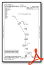
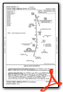
Instrument Approach Procedure (IAP) Charts


Departure Procedure (DP) Charts

Nearby Airports with Instrument Procedures
| ID | Name | Heading / Distance | ||
|---|---|---|---|---|
 |
7FL6 | Spruce Creek Airport | 174° | 6.0 |
|
KOMN | Ormond Beach Municipal Airport | 338° | 7.8 |
|
KEVB | New Smyrna Beach Municipal (Jack Bolt Field) Airport | 142° | 9.4 |
|
KDED | Deland Municipal-Sidney H Taylor Field Airport | 240° | 13.7 |
|
X50 | Massey Ranch Airpark Airport | 149° | 13.9 |
|
KFIN | Flagler Exec Airport | 335° | 18.8 |
|
KSFB | Orlando Sanford International Airport | 201° | 25.8 |
|
X23 | Umatilla Municipal Airport | 244° | 34.8 |
|
X21 | Arthur Dunn Air Park Airport | 160° | 35.4 |
|
KTTS | Space Florida Launch and Landing Facility Airport | 150° | 38.9 |
|
X04 | Orlando Apopka Airport | 224° | 39.5 |
|
KORL | Orlando Exec Airport | 200° | 40.6 |
Fuel Providers

Airport Images
Do you have a recent image of this airport? Upload it here!


