Login
Register


SFB
Orlando Sanford International Airport
Official FAA Data Effective 2025-11-27 0901Z
From the Flight Deck
Chart Supplement

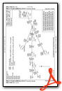
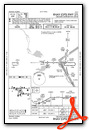
KSFB Airport Diagram

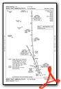
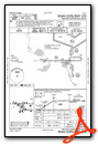
VFR Chart of KSFB
Sectional Charts at SkyVector.com
IFR Chart of KSFB
Enroute Charts at SkyVector.com
Location Information for KSFB
Coordinates: N28°46.63' / W81°14.09'Located 16 miles NE of Orlando, Florida on 3000 acres of land. View all Airports in Florida.
Surveyed Elevation is 54 feet MSL.
Operations Data
|
|
Airport Communications
| ATIS: | 125.975 |
|---|---|
| ASOS: | 125.975 Tel. 407-321-9384 |
| SANFORD TOWER: | 120.3 135.25 254.35 |
| SANFORD GROUND: | 121.35 254.35 |
| ORLANDO APPROACH: | 125.225 ;SOUTH 135.3 ;NORTH 351.9 |
| ORLANDO DEPARTURE: | 125.225 ;SOUTH 135.3 ;NORTH 351.9 |
| CLEARANCE DELIVERY: | 123.975 121.35 ;WHEN SFB TWR CLSD |
| SHREK STAR: | 128.675 263.05 134.05 339.8 |
| PRICY STAR: | 134.05 339.8 |
| EMERG: | 121.5 |
| TTHOR STAR: | 118.85 353.825 125.225 351.9 |
| RIDES STAR: | 128.375 338.2 |
| SANFORD DP: | 135.3 351.9 |
| JOKRS STAR: | 134.05 339.8 |
| CTAF: | 120.300 |
| ALYNA STAR: | 124.8 307.0 |
| CWRLD STAR: | 307.0 |
| CLASS C: | 125.225 ;SOUTH OF SFB WITHIN 20 NM 3500 FT & BLW 135.3 ;NORTH OF SFB WITHIN 20 NM 3500 FT & BLW 351.9 ;N. OF SFB WITHIN 20 NM 3500 FT & BLW 351.9 ;S. OF SFB WITHIN 20 NM 3500 FT & BLW |
| MINEE STAR: | 134.05 339.8 |
| ATIS at ORL (14.8 S): | 127.25 |
| ASOS at ORL (14.8 S): | 127.25 407-658-6753 |
| AWOS-3 at DED (17.6 N): | 119.575 386-740-5811 |
- 123.975 CLNC DEL AVBL WHEN ADVERTISED ON ATIS.
- SAID IN USE. OPERATE TRANSPONDERS WITH ALTITUDE REPORTING MODE AND ADS-B (IF EQUIPPED) ENABLED ON ALL AIRPORT SURFACES.
Nearby Navigation Aids
|
| ||||||||||||||||||||||||||||||||||||||||||


Runway 09L/27R
PRIM ACR OPS RWY. | ||
| Dimensions: | 11002 x 150 feet / 3353 x 46 meters | |
|---|---|---|
| Surface: | Asphalt / Grooved in Good Condition | |
| Weight Limits: | S-100, D-279, ST-840
PCR VALUE: 1490/F/A/X/T
| |
| Edge Lighting: | High Intensity | |
| Runway 09L | Runway 27R | |
| Coordinates: | N28°46.90' / W81°15.36' | N28°46.91' / W81°13.30' |
| Elevation: | 51.6 | 30.3 |
| Traffic Pattern: | Left | Right |
| Runway Heading: | 90° True | 270° True |
| Displaced Threshold: | 1000 Feet | |
| Declared Distances: | TORA:11002 TODA:11002 ASDA:11002 LDA:10002 | TORA:11002 TODA:11002 ASDA:11002 LDA:11002 |
| Markings: | Precision Instrument in good condition. | Precision Instrument in good condition. |
| Glide Slope Indicator | P4L (3.00° Glide Path Angle) | P4R (3.00° Glide Path Angle) |
| Approach Lights: | MALSR 1,400 Foot Medium-intensity Approach Lighting System with runway alignment indicator lights. | MALSR 1,400 Foot Medium-intensity Approach Lighting System with runway alignment indicator lights. |
| Obstacles: | 49 ft Trees 1000 ft from runway, 280 ft left of center RWY 09L APCH 50:1 TO MKD DTHR. |
|
Runway 18/36
PRIM ACR OPS RWY. | ||
| Dimensions: | 6002 x 150 feet / 1829 x 46 meters | |
|---|---|---|
| Surface: | Asphalt-Concrete / Grooved in Fair Condition CNTR 75 FT GOOD COND; OUTER EDGE FAIR COND. | |
| Weight Limits: | S-111, D-183, ST-599
PCR VALUE: 596/R/A/W/T
| |
| Edge Lighting: | Medium Intensity | |
| Runway 18 | Runway 36 | |
| Coordinates: | N28°47.00' / W81°14.09' | N28°46.01' / W81°14.09' |
| Elevation: | 48.3 | 43.0 |
| Traffic Pattern: | Left | Right |
| Runway Heading: | 180° True | 360° True |
| Declared Distances: | TORA:6002 TODA:6002 ASDA:5956 LDA:5956 | TORA:6002 TODA:6002 ASDA:6002 LDA:6002 |
| Markings: | Non-Precision Instrument in good condition. | Non-Precision Instrument in good condition. |
| Glide Slope Indicator | P4L (3.00° Glide Path Angle) | P4L (3.00° Glide Path Angle) |
| REIL: | Yes | Yes |
| Obstacles: | 35 ft Trees 1450 ft from runway, 10 ft right of center | 32 ft Trees 1005 ft from runway, 295 ft right of center |
Runway 09R/27L
RWY 09R/27L NOT AVBL FOR PART 121/PART 380 OPS WITH SKED PAX CARRYING OPS MORE THAN 9 PAX SEATS AND NON-SKED PAX CARRYING OPS MORE THAN 30 PAX SEATS. PRI FLT T RWY. | ||
| Dimensions: | 5839 x 75 feet / 1780 x 23 meters | |
|---|---|---|
| Surface: | Asphalt in Fair Condition | |
| Weight Limits: | S-67, D-80
PCR VALUE: 310/F/A/X/T
| |
| Edge Lighting: | High Intensity | |
| Runway 09R | Runway 27L | |
| Coordinates: | N28°46.20' / W81°14.03' | N28°46.20' / W81°12.94' |
| Elevation: | 45.0 | 24.4 |
| Traffic Pattern: | Right | |
| Runway Heading: | 90° True | 270° True |
| Displaced Threshold: | 839 Feet | |
| Declared Distances: | TORA:5839 TODA:5839 ASDA:5839 LDA:5000 | TORA:5839 TODA:5839 ASDA:5839 LDA:5839 |
| Markings: | Precision Instrument in fair condition. | Non-Precision Instrument in fair condition. |
| Glide Slope Indicator | P4L (3.00° Glide Path Angle) | P4L (3.00° Glide Path Angle) |
| Approach Lights: | MALSR 1,400 Foot Medium-intensity Approach Lighting System with runway alignment indicator lights. | |
| REIL: | Yes | |
| Obstacles: | 65 ft Trees 3475 ft from runway, 300 ft right of center | 37 ft Trees 1875 ft from runway, 95 ft left of center |
Runway 09C/27C
RWY 09C/27C NOT AVBL FOR PART 121/PART 380 OPS WITH SKED PAX CARRYING OPS MORE THAN 9 PAX SEATS AND NON-SKED PAX CARRYING OPS MORE THAN 30 PAX SEATS. | ||
| Dimensions: | 3578 x 75 feet / 1091 x 23 meters | |
|---|---|---|
| Surface: | Asphalt in Fair Condition | |
| Weight Limits: | S-12
PCR VALUE: 960/F/A/X/T
| |
| Edge Lighting: | Medium Intensity | |
| Runway 09C | Runway 27C | |
| Coordinates: | N28°46.71' / W81°14.73' | N28°46.71' / W81°14.06' |
| Elevation: | 51.5 | 47.6 |
| Traffic Pattern: | Right | |
| Runway Heading: | 90° True | 270° True |
| Declared Distances: | TORA:3578 TODA:3578 ASDA:3578 LDA:3578 | TORA:3578 TODA:3578 ASDA:3578 LDA:3578 |
| Markings: | Basic in good condition. | Basic in good condition. |
| Glide Slope Indicator | P2L (4.00° Glide Path Angle) | P2L (3.00° Glide Path Angle) |
| REIL: | Yes | |
| Obstacles: | 53 ft Trees 2020 ft from runway, 65 ft left of center | 51 ft Trees 2245 ft from runway, 125 ft left of center |
Services Available
| Fuel: | 100LL (blue), Jet-A |
|---|---|
| Transient Storage: | Hangars,Tiedowns |
| Airframe Repair: | MAJOR |
| Engine Repair: | MAJOR |
| Bottled Oxygen: | HIGH |
| Bulk Oxygen: | NONE |
| Other Services: | AVIONICS,CARGO HANDLING SERVICES,CHARTER SERVICE,PILOT INSTRUCTION,AIRCRAFT RENTAL,AIRCRAFT SALES |
Ownership Information
| Ownership: | Publicly owned | |
|---|---|---|
| Owner: | SANFORD ARPT AUTHORITY | |
| 1200 RED CLEVELAND BLVD, SUITE #200 | ||
| SANFORD, FL 32773-0818 | ||
| 407-585-4101 | ||
| Manager: | NICOLE MARTZ | NICOLE MARTZ (PRESIDENT & CEO) |
| 1200 RED CLEVELAND BLVD | ||
| SANFORD, FL 32773 | ||
| 407-585-4101 | ||
Other Remarks
- PAEW ON TRML RAMP WI 75 FT OF TWY C CNTRLN WHEN ACFT USING GATES 7 OR 8.
- TWY P CLSD TO ACFT WITH WINGSPAN GREATER THAN 40 FT.
- DUE TO FACILITY CONSTRAINTS THAT LIMIT ABILITY TO ACCOMMODATE DIVERTED FLIGHTS AIRCRAFT OPERATORS TO CONTACT THE AIRPORT AT 407-585-4101 FOR PRIOR COORDINATION, EXCEPT IN CASE OF A DECLARED IN-FLIGHT EMERGENCY
- FOR TKOF TBJTS USE FAA NADP-2 COMPARABLE ACR OPS SPECS PROFILE OR NBAA PROFILE. ON VISUAL APCHS PILOTS ARE REQUESTED TO DLA LDG GEAR EXTN TIL OPRLY NEC.
- TWY K CLSD TO ACFT WITH WINGSPAN GTR THAN 79 FT.
- ALL UNSCHEDULED ACR WITH AT LEAST 31 PSGR SEATS PPR CTC DIRECTOR OF OPS 407-585-4112 OR 407-585-4119
- CALM WIND RWY - WHEN WIND IS LESS THAN 5KTS, RWY09L IS PREF FOR ALL ACR AND LARGE ACFT, RWY 09R PREF FOR GA OPS.
- FLT TRNG ACT IN TFC PAT & LCL AREA.
- LRG AND/OR FLOCKING BIRDS; INCLG EAGLES INVOF ARPT.
- ALL ACFT ARR WITH LESS THAN 30 SEATS TO CLEAR CUSTOMS CTC 129.075 PRIOR TO LNDG.
- WHEN ATCT CLSD ACTVT MALSR RWY 9R & 27R; PAPI RWYS 09L, 27R, 09C, 27C, 09R, 27L, 18, & 36; HIRL RWY 09L/27R, 09R/27L; MIRL RWY 18/36 & 9C/27C - CTAF.
Weather Minimums

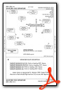
Standard Terminal Arrival (STAR) Charts
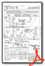
- ALYNA FOUR (RNAV)

- JOKRS THREE (RNAV)

- JOKRS THREE (RNAV), CONT.1
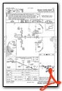
- MINEE SIX

- MINEE SIX, CONT.1

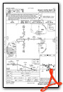
- PRICY FOUR (RNAV)
- PRICY FOUR (RNAV), CONT.1

- PRICY FOUR (RNAV), CONT.2

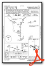
- RIDES TWO (RNAV)

- RIDES TWO (RNAV), CONT.1
- RIDES TWO (RNAV), CONT.2

- SHREK TWO (RNAV)

- SLOAO ONE (RNAV)

- TTHOR THREE (RNAV)

- TTHOR THREE (RNAV), CONT.1

Instrument Approach Procedure (IAP) Charts


Departure Procedure (DP) Charts
Nearby Airports with Instrument Procedures
| ID | Name | Heading / Distance | ||
|---|---|---|---|---|
 |
KORL | Orlando Exec Airport | 200° | 14.8 |
|
KDED | Deland Municipal-Sidney H Taylor Field Airport | 351° | 17.5 |
|
X04 | Orlando Apopka Airport | 257° | 18.8 |
|
X50 | Massey Ranch Airpark Airport | 053° | 20.3 |
|
7FL6 | Spruce Creek Airport | 028° | 20.7 |
|
KMCO | Orlando International Airport | 190° | 21.2 |
|
KEVB | New Smyrna Beach Municipal (Jack Bolt Field) Airport | 042° | 22.5 |
|
X21 | Arthur Dunn Air Park Airport | 113° | 23.0 |
|
X23 | Umatilla Municipal Airport | 292° | 23.7 |
|
KDAB | Daytona Beach International Airport | 021° | 25.8 |
|
KTIX | Space Coast Regional Airport | 124° | 27.8 |
|
KTTS | Space Florida Launch and Landing Facility Airport | 108° | 30.1 |
Fuel Providers

Airport Images
Do you have a recent image of this airport? Upload it here!


