Login
Register
EDLA
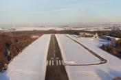
Arnsberg Airport
VFR Chart of EDLA
Sectional Charts at SkyVector.com
IFR Chart of EDLA
Enroute Charts at SkyVector.com
Location Information for EDLA
Coordinates: N51°29.00' / E7°53.96'View all Airports in Nordrhein-Westfalen, Germany.
Elevation is 794.0 feet MSL.
Operations Data
|
|
Airport Communications
| ARNSBERG INFO Tower: | 122.50 |
|---|---|
| ARNSBERG INFO Tower: | 123.02 |
Nearby Navigation Aids
|
| ||||||||||||||||||||||||||||||||||||||||||||||||||||||||||||
Runway 05/23
| Dimensions: | 3018 x 66 feet / 920 x 20 meters | |
|---|---|---|
| Surface: | Hard | |
| Runway 05 | Runway 23 | |
| Coordinates: | N51°28.82' / E7°53.62' | N51°29.14' / E7°54.23' |
| Elevation: | 793 | 762 |
| Runway Heading: | 049° | 229° |
Nearby Airports with Instrument Procedures
| ID | Name | Heading / Distance | ||
|---|---|---|---|---|
 |
EDLW | Dortmund Airport | 281° | 11.0 |
 |
EDLP | Paderborn Lippstadt Airport | 073° | 28.0 |
 |
EDDG | Muenster-Osnabrueck Airport | 348° | 39.9 |
 |
EDDL | Duesseldorf Airport | 254° | 44.6 |
 |
EDDK | Koeln/Bonn Airport | 217° | 46.8 |
 |
EDGS | Siegerland Airport | 171° | 47.1 |
 |
EDLN | Moenchengladbach Airport | 254° | 54.6 |
 |
EDVK | Kassel-Calden Airport | 093° | 56.2 |
 |
ETHF | Fritzlar Airport | 112° | 56.7 |
 |
ETNN | Norvenich Airport | 230° | 61.1 |
 |
ETHB | Buckeburg Airport | 042° | 64.9 |
 |
EDLV | Niederrhein Airport | 276° | 66.2 |


Comments
Wrong frequency
The right frequency of the tower is 121.21
Dr. Wolfram Schiffmann