Login
Register


FAR
Hector International Airport
Official FAA Data Effective 2026-01-22 0901Z
Chart Supplement

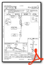
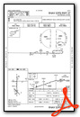
KFAR Airport Diagram

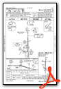
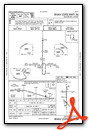
VFR Chart of KFAR
Sectional Charts at SkyVector.com
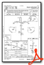
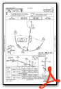
IFR Chart of KFAR
Enroute Charts at SkyVector.com
Location Information for KFAR
Coordinates: N46°55.24' / W96°48.94'Located 03 miles NW of Fargo, North Dakota on 2500 acres of land. View all Airports in North Dakota.
Surveyed Elevation is 901 feet MSL.
Operations Data
|
|
Airport Communications
| ATIS: | 124.5 379.2 |
|---|---|
| ASOS: | Tel. 701-289-3069 |
| FARGO TOWER: | 133.8 290.4 |
| FARGO GROUND: | 121.9 348.6 |
| FARGO APPROACH: | 120.4 125.125 370.85 377.15 |
| FARGO DEPARTURE: | 120.4 125.125 370.85 377.15 |
| IC: | 133.8 290.4 |
| CLEARANCE DELIVERY: | 121.9 348.6 |
| UNICOM: | 122.950 |
| TRSA: | 120.4 377.15 |
| EMERG: | 121.5 243.0 |
| AWOS-3 at JKJ (7.9 SE): | 120.0 218-287-5049 |
| AWOS-3PT at DTL (38.6 E): | 119.075 218-847-8626 |
| AWOS-3 at BWP (41.5 S): | 127.875 701-642-9800 |
Nearby Navigation Aids
|
| ||||||||||||||||||||||||||||||||||||||||||||||||||||||


Runway 18/36
| Dimensions: | 9001 x 150 feet / 2744 x 46 meters | |
|---|---|---|
| Surface: | Concrete / Grooved in Good Condition | |
| Weight Limits: | S-100, D-200, ST-400
AUW-847
PCR VALUE: 855/R/D/W/U
| |
| Edge Lighting: | High Intensity | |
| Runway 18 | Runway 36 | |
| Coordinates: | N46°55.97' / W96°48.97' | N46°54.49' / W96°48.98' |
| Elevation: | 899.8 | 899.3 |
| Traffic Pattern: | Left | |
| Runway Heading: | 180° True | 0 |
| Declared Distances: | TORA:9001 TODA:9001 ASDA:9001 LDA:9001 | TORA:9001 TODA:9001 ASDA:9001 LDA:9001 |
| Markings: | Precision Instrument in good condition. | Precision Instrument in good condition. |
| Glide Slope Indicator | P4L (3.00° Glide Path Angle) | P4R (3.00° Glide Path Angle) |
| RVR Equipment | Touchdown Rollout | Touchdown Rollout |
| Approach Lights: | MALSR 1,400 Foot Medium-intensity Approach Lighting System with runway alignment indicator lights. | MALSR 1,400 Foot Medium-intensity Approach Lighting System with runway alignment indicator lights. |
Runway 09/27
| Dimensions: | 6302 x 100 feet / 1921 x 30 meters | |
|---|---|---|
| Surface: | Concrete / Grooved in Good Condition | |
| Weight Limits: | S-60, D-100
PCR VALUE: 263/R/D/W/U
| |
| Edge Lighting: | Medium Intensity | |
| Runway 09 | Runway 27 | |
| Coordinates: | N46°55.63' / W96°49.64' | N46°55.62' / W96°48.13' |
| Elevation: | 896.2 | 898.6 |
| Runway Heading: | 90° True | 270° True |
| Declared Distances: | TORA:6302 TODA:6302 ASDA:6302 LDA:6302 | TORA:6302 TODA:6302 ASDA:6302 LDA:6302 |
| Markings: | Non-Precision Instrument in good condition. | Non-Precision Instrument in good condition. |
| Glide Slope Indicator | P4L (3.00° Glide Path Angle) | P4L (3.00° Glide Path Angle) |
| REIL: | Yes | Yes |
| Obstacles: | 25 ft Pole 1086 ft from runway, 468 ft left of center | |
Runway 13/31
RWY 13/31 NOT AVBL FOR PART 121/PART 380 OPS WITH SKED PAX CARRYING OPS MORE THAN 9 PAX SEATS AND NON-SKED PAX CARRYING OPS MORE THAN 30 PAX SEATS. | ||
| Dimensions: | 3801 x 75 feet / 1159 x 23 meters | |
|---|---|---|
| Surface: | Concrete / Grooved in Good Condition | |
| Weight Limits: | 17 /R/D/W/T, S-26, D-35 | |
| Edge Lighting: | Medium Intensity | |
| Runway 13 | Runway 31 | |
| Coordinates: | N46°54.85' / W96°49.29' | N46°54.39' / W96°48.67' |
| Elevation: | 901.3 | 898.5 |
| Traffic Pattern: | Left | Left |
| Runway Heading: | 137° True | 317° True |
| Declared Distances: | TORA:3801 TODA:3801 ASDA:3801 LDA:3801 | TORA:3801 TODA:3801 ASDA:3801 LDA:3801 |
| Markings: | Basic in good condition. | Basic in good condition. |
| Glide Slope Indicator | P2R (3.00° Glide Path Angle) | P2L (3.00° Glide Path Angle) |
| Obstacles: | 7 ft Road 550 ft from runway, 180 ft right of center | 8 ft Road 432 ft from runway, 147 ft left of center |
Services Available
| Fuel: | 100LL (blue), Jet-A, Jet A+, A++, J8 |
|---|---|
| Transient Storage: | Hangars,Tiedowns |
| Airframe Repair: | MAJOR |
| Engine Repair: | MAJOR |
| Bottled Oxygen: | HIGH/LOW |
| Bulk Oxygen: | HIGH/LOW |
| Other Services: | AIR AMBULANCE SERVICES,AVIONICS,CHARTER SERVICE,PILOT INSTRUCTION,AIRCRAFT RENTAL,AIRCRAFT SALES,ANNUAL SURVEYING |
Ownership Information
| Ownership: | Publicly owned | |
|---|---|---|
| Owner: | MUNI ARPT AUTH OF THE CITY OF FARGO | |
| PO BOX 2845 | ||
| FARGO, ND 58108 | ||
| 701-241-1501 | ||
| Manager: | SHAWN DOBBERSTEIN | |
| PO BOX 2845 | ||
| FARGO, ND 58108 | ||
| 701-241-1501 | ||
Other Remarks
- TWY B N OF TWY D RSTRD TO ACFT LESS THAN 130,000 LBS.
- REMARKS: SEE FLIP AP/1 SUPPLEMENTARY ARPT INFO INCL BASH INFO.
- CAUTION: USE EXTREME CAUTION FOR UAS OPS IN VCNTY.
- ANG: BIRD HAZARD (BASH PHASE II) MAR-MAY, AUG-DEC.
- FLIGHT NOTIFICATION SERVICE (ADCUS) AVAILABLE MON-FRI 0830-1700.
- MILITARY: ANG: OFFL BUS ONLY CTC BASE OPS DSN 362-8508, C701-451-2508 OPR 1130-2200Z++ CLSD FRI, SAT, SUN & HOL EXC DUR SKED TRNG. OTHER TRAN ACFT CTC JET CNTR C701-235-3600; CSTMS AVBL 24 HR. RCR AVBL FR ANG OPS ON 262.0. RGT TFC RWY 18.
- BIRDS ON AND INVOF ARPT.
Weather Minimums


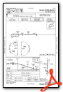
Instrument Approach Procedure (IAP) Charts
Nearby Airports with Instrument Procedures
| ID | Name | Heading / Distance | ||
|---|---|---|---|---|
 |
KJKJ | Moorhead Municipal/Florence Klingensmith Field Airport | 127° | 7.9 |
|
5N8 | Casselton Robert Miller Regional Airport | 256° | 16.6 |
|
K74 | Robert Odegaard Field Airport | 204° | 18.0 |
|
04Y | Hawley Municipal Airport | 096° | 19.3 |
|
D00 | Norman County Ada/Twin Valley Airport | 039° | 26.6 |
|
3H4 | Hillsboro Municipal Airport | 339° | 28.2 |
|
KDTL | Detroit Lakes/Wething Field Airport | 098° | 38.8 |
|
KBWP | Harry Stern Airport | 167° | 41.5 |
|
3N8 | Mahnomen County Airport | 060° | 41.7 |
|
D14 | Fertile Municipal Airport | 029° | 43.5 |
|
KFFM | Fergus Falls Regional Airport | 144° | 46.9 |
|
6L3 | Lisbon Municipal Airport | 233° | 47.2 |
Airport Images
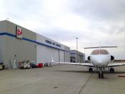
By: winglet714

By: winglet714


