Login
Register


6L3
Lisbon Municipal Airport
Official FAA Data Effective 2026-02-19 0901Z
Chart Supplement

VFR Chart of 6L3
Sectional Charts at SkyVector.com
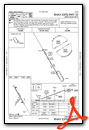
IFR Chart of 6L3
Enroute Charts at SkyVector.com
Location Information for 6L3
Coordinates: N46°26.82' / W97°43.69'Located 02 miles W of Lisbon, North Dakota on 212 acres of land. View all Airports in North Dakota.
Surveyed Elevation is 1240 feet MSL.
Operations Data
|
|
Airport Communications
| CTAF: | 122.900 |
|---|---|
| AWOS-3 at GWR (14.2 S): | 118.325 701-678-6801 |
| AWOS-3 at 2D5 (22.0 SW): | 118.675 701-742-3991 |
| AWOS-3 at BAC (32.0 N): | 118.725 701-845-9117 |
- APCH/DEP SVC PRVDD BY MINNEAOPLIS ARTCC ON 127.35/278.3 (FARGO RCAG).
Nearby Navigation Aids
|
| ||||||||||||||||||||||||||||||||||||||||||||||||


Runway 14/32
| Dimensions: | 3397 x 60 feet / 1035 x 18 meters | |
|---|---|---|
| Surface: | Asphalt in Good Condition | |
| Weight Limits: | S-12 | |
| Edge Lighting: | Medium Intensity | |
| Runway 14 | Runway 32 | |
| Coordinates: | N46°27.12' / W97°43.88' | N46°26.63' / W97°43.48' |
| Elevation: | 1231.8 | 1225.4 |
| Traffic Pattern: | Left | Left |
| Runway Heading: | 150° True | 330° True |
| Markings: | Non-Precision Instrument in good condition. | Non-Precision Instrument in good condition. |
| Glide Slope Indicator | P2L (3.00° Glide Path Angle) | P2L (3.00° Glide Path Angle) |
| Obstacles: | 6 ft Fence 275 ft from runway, 260 ft left of center | 20 ft Road 590 ft from runway, 310 ft left of center |
Runway 03/21
| Dimensions: | 1320 x 100 feet / 402 x 30 meters | |
|---|---|---|
| Surface: | Turf in Good Condition | |
| Runway 03 | Runway 21 | |
| Coordinates: | N46°26.59' / W97°43.82' | N46°26.77' / W97°43.64' |
| Elevation: | 1240.3 | 1228.4 |
| Traffic Pattern: | Left | Left |
| Runway Heading: | 34° True | 214° True |
| Markings: | None | None |
Services Available
| Fuel: | 100LL (blue) |
|---|---|
| Transient Storage: | Hangars,Tiedowns |
| Airframe Repair: | NOT AVAILABLE |
| Engine Repair: | NOT AVAILABLE |
| Bottled Oxygen: | NOT AVAILABLE |
| Bulk Oxygen: | NOT AVAILABLE |
| Other Services: | CROP DUSTING SERVICES |
Ownership Information
| Ownership: | Publicly owned | |
|---|---|---|
| Owner: | LISBON AIRPORT AUTHORITY | MEMBER OF ARPT AUTHORITY RICHARD KIRSCH 701-308-1349. |
| PO BOX 1079 | ||
| LISBON, ND 58054 | ||
| 701-683-4140 | CITY HALL OF LISBON. | |
| Manager: | BEN HALSTENSON | |
| 6683 129TH AVE SE, 423 MAIN STREET | ||
| LISBON, ND 58054 | ||
| 701-739-5463 | ||
Other Remarks
- CTC AMGR BFR USE AFT WINTER STORM DUE TO IREG SN REMOVAL; CALL 701-739-5463.
- ULTRALIGHT ACTIVITY ON OR NEAR VICINITY OF AIRPORT.
- RY 03/21 CLSD WINTER MONTHS DUE TO LACK OF SNOW REMOVAL.
- BIRDS & DEER INVOF AIRPORT.
- FOR CD CTC MINNEAPOLIS ARTCC AT 651-463-5588.
- 0LL SELF SVC FUEL AVBL H24 VIA CREDIT CARD.
- ACTVT PAPI RWY 14 & 32; MIRL RWY 14/32 - CTAF.
Weather Minimums

Instrument Approach Procedure (IAP) Charts

Nearby Airports with Instrument Procedures
| ID | Name | Heading / Distance | ||
|---|---|---|---|---|
 |
KGWR | Gwinner/Roger Melroe Field Airport | 165° | 14.2 |
|
2D5 | Oakes Municipal Airport | 221° | 22.0 |
|
KBAC | Barnes County Municipal Airport | 338° | 32.0 |
|
K74 | Robert Odegaard Field Airport | 067° | 32.5 |
|
5N8 | Casselton Robert Miller Regional Airport | 041° | 32.5 |
|
KBTN | Britton Municipal Airport | 180° | 37.9 |
|
4E7 | Ellendale Municipal Airport | 232° | 41.8 |
|
51D | Edgeley Municipal Airport | 262° | 42.2 |
|
KFAR | Hector International Airport | 052° | 47.2 |
|
KBWP | Harry Stern Airport | 104° | 48.2 |
|
KJMS | Jamestown Regional Airport | 306° | 48.8 |
|
KJKJ | Moorhead Municipal/Florence Klingensmith Field Airport | 061° | 49.9 |
Airport Images
Do you have a recent image of this airport? Upload it here!


