Login
Register


FSP
Nikolai Airport
Official FAA Data Effective 2026-01-22 0901Z
Chart Supplement

VFR Chart of PAFS
Sectional Charts at SkyVector.com
IFR Chart of PAFS
Enroute Charts at SkyVector.com
Location Information for PAFS
Coordinates: N63°1.11' / W154°21.51'Located 01 miles NE of Nikolai, Alaska on 76 acres of land. View all Airports in Alaska.
Surveyed Elevation is 447 feet MSL.
Operations Data
|
|
Airport Communications
| AWOS-3P: | 118.325 Tel. 907-560-7606 |
|---|---|
| CTAF: | 122.800 |
| ASOS at MCG (34.3 W): | 135.65 907-524-3850 |
| AWOS-3 at TLJ (44.8 W): | 907-552-1106 |
- APCH/DEP SVC PRVDD BY ANCHORAGE ARTCC ON FREQS 128.1/353.8 (MC GRATH RCAG).
Nearby Navigation Aids
|
| ||||||||||||||||||

Runway 05/23
| Dimensions: | 4001 x 75 feet / 1220 x 23 meters | |
|---|---|---|
| Surface: | Gravel in Good Condition | |
| Edge Lighting: | Medium Intensity MULT LGTS BROKEN ENTIRE LEN. BRUSH & GRASS OBSC LGTS. | |
| Runway 05 | Runway 23 | |
| Coordinates: | N63°0.97' / W154°22.15' | N63°1.26' / W154°20.86' |
| Elevation: | 445.4 | 447.2 |
| Traffic Pattern: | Left | Left |
| Runway Heading: | 63° True | 243° True |
| Markings: | None in fair condition. | None in fair condition. |
| Glide Slope Indicator | P4L (3.20° Glide Path Angle) | P4L (3.20° Glide Path Angle) |
| REIL: | Yes | Yes |
| Obstacles: | 10 ft Brush 0 ft from runway, 139 ft left of center | 10 ft Brush 12 ft from runway, 92 ft left of center |
Ownership Information
| Ownership: | Publicly owned | |
|---|---|---|
| Owner: | ALASKA DOT&PF CENTRAL REGION | |
| PO BOX 196900 | ||
| ANCHORAGE, AK 99519-6900 | ||
| 907-269-0782 | ||
| Manager: | STEFFEN STRICK | |
| PO BOX 21 | ||
| MCGRATH, AK 99627 | ||
| 907-524-3241 | ||
Other Remarks
- RWY COND UNMNT; RCMD VISUAL INSP BFR USE.
- WX CAMERA AVBL ON INTERNET AT HTTPS://WEATHERCAMS.FAA.GOV.
- ACTVT REIL RWY 05 & 23; PAPI RWY 05 & 23; MIRL RWY 05/23 - CTAF.
- ACVT ROTG BCN - CTAF.
Weather Minimums

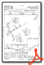
Instrument Approach Procedure (IAP) Charts

Nearby Airports with Instrument Procedures
| ID | Name | Heading / Distance | ||
|---|---|---|---|---|
 |
PAMC | Mc Grath Airport | 263° | 34.4 |
|
PAMH | Minchumina Airport | 045° | 76.1 |
|
PARY | Ruby Airport | 344° | 107.0 |
|
PASL | Sleetmute Airport | 225° | 111.6 |
|
PAGA | Edward G Pitka Sr Airport | 327° | 123.9 |
Airport Images
Do you have a recent image of this airport? Upload it here!


