Login
Register


RBY
Ruby Airport
Official FAA Data Effective 2026-02-19 0901Z
Chart Supplement

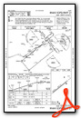
VFR Chart of PARY
Sectional Charts at SkyVector.com
IFR Chart of PARY
Enroute Charts at SkyVector.com
Location Information for PARY
Coordinates: N64°43.63' / W155°28.19'Located 01 miles SE of Ruby, Alaska. View all Airports in Alaska.
Surveyed Elevation is 657 feet MSL.
Operations Data
|
|
Airport Communications
| AWOS-3P: | 118.25 Tel. 907-468-4605 |
|---|---|
| CTAF: | 122.800 |
| AWOS-3P at GAL (37.2 W): | 132.525 907-656-2483 |
| AWOS-3P at HLA (62.4 N): | 135.75 907-829-2282 |
- APCH/DEP SVC PRVDD BY ANCHORAGE ARTCC ON FREQS 127.0/290.2 (GALENA RCAG).
- COMMUNICATIONS PRVDD BY FAIRBANKS FSS ON FREQ 122.25 (RUBY RCO).
Nearby Navigation Aids
|
| ||||||||||||||||||||||||

Runway 03/21
| Dimensions: | 4000 x 100 feet / 1219 x 30 meters | |
|---|---|---|
| Surface: | Gravel in Good Condition DOWN SLOPE TO MID. | |
| Edge Lighting: | Medium Intensity | |
| Runway 03 | Runway 21 | |
| Coordinates: | N64°43.43' / W155°28.79' | N64°43.84' / W155°27.60' |
| Elevation: | 647.6 | 657.5 |
| Traffic Pattern: | Left | Left |
| Runway Heading: | 51° True | 231° True |
| Glide Slope Indicator | P4L (3.00° Glide Path Angle) | |
| REIL: | Yes | |
| Obstacles: | 19 ft Trees 0 ft from runway, 166 ft right of center | 10 ft Brush 0 ft from runway, 150 ft right of center |
Services Available
| Fuel: | NONE |
|---|---|
| Transient Storage: | Tiedowns WINTER RECEPTACLES AVBL NEAR TIE-DOWN. |
| Airframe Repair: | NOT AVAILABLE |
| Engine Repair: | NOT AVAILABLE |
| Bottled Oxygen: | NOT AVAILABLE |
| Bulk Oxygen: | NOT AVAILABLE |
Ownership Information
| Ownership: | Publicly owned | |
|---|---|---|
| Owner: | ALASKA DOT&PF NORTHERN REGION | |
| 2301 PEGER RD | ||
| FAIRBANKS, AK 99709 | ||
| (907) 451-5280 | ||
| Manager: | JASON LUDINGTON | |
| 2301 PEGER RD | ||
| FAIRBANKS, AK 99709 | ||
| (907) 451-5280 | ||
Other Remarks
- RWY COND UNMN; RCMND VISUAL INSP BFR LNDG.
- WX CAMERA AVBL ON INTERNET AT HTTPS://WEATHERCAMS.FAA.GOV
- COLD TEMPERATURE AIRPORT. ALTITUDE CORRECTION REQUIRED AT OR BELOW -39C.
- BIRDS INVOF LANDFILL 1 MI SW OF RWY.
- DOWN SLOPE 2 PCT GRADE.
- ACTVT REIL RWY 21; PAPI RWY 21; MIRL RWY 03/21 - CTAF.
- ACTVT ROTG BCN - CTAF.
Weather Minimums

Instrument Approach Procedure (IAP) Charts

Nearby Airports with Instrument Procedures
| ID | Name | Heading / Distance | ||
|---|---|---|---|---|
 |
PAGA | Edward G Pitka Sr Airport | 271° | 37.7 |
|
PFKU | Koyukuk Airport | 279° | 58.7 |
|
PAHL | Huslia Airport | 339° | 62.5 |
|
PANU | Nulato Airport | 271° | 67.0 |
|
PAHU | Hughes Airport | 020° | 84.6 |
|
PAMC | Mc Grath Airport | 182° | 106.9 |
|
PAFS | Nikolai Airport | 163° | 107.0 |
|
PFAL | Allakaket Airport | 031° | 130.7 |
Airport Images
Do you have a recent image of this airport? Upload it here!


