Login
Register


GAM
Gambell Airport
Official FAA Data Effective 2026-01-22 0901Z
Chart Supplement

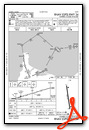
VFR Chart of PAGM
Sectional Charts at SkyVector.com
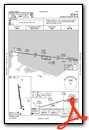
IFR Chart of PAGM
Enroute Charts at SkyVector.com
Location Information for PAGM
Coordinates: N63°46.00' / W171°43.97'Located 00 miles SW of Gambell, Alaska on 200 acres of land. View all Airports in Alaska.
Surveyed Elevation is 29 feet MSL.
Operations Data
|
|
Airport Communications
| AWOS-3P: | 125.9 Tel. 907-560-7605 |
|---|---|
| CTAF: | 122.700 |
| AWOS-3P at SVA (33.3 E): | 121.3 907-560-7600 |
- APCH/DEP SVC PRVDD BY ANCHORAGE ARTCC ON FREQS 132.2/281.4 (GAMBELL RCAG).
- COMMUNICATIONS PRVDD BY NOME FSS ON FREQ 122.0 (GAMBELL RCO).
Nearby Navigation Aids
|
| ||||||||||||||||||||||||||||||


Runway 16/34
SAFETY AREAS SOFT & LOOSE GRVL. | ||
| Dimensions: | 4500 x 100 feet / 1372 x 30 meters | |
|---|---|---|
| Surface: | Asphalt-Concrete in Fair Condition | |
| Weight Limits: | S-22 | |
| Edge Lighting: | Medium Intensity | |
| Runway 16 | Runway 34 | |
| Coordinates: | N63°46.36' / W171°44.08' | N63°45.63' / W171°43.85' |
| Elevation: | 29.5 | 28.8 |
| Traffic Pattern: | Right | Left |
| Runway Heading: | 172° True | 352° True |
| Markings: | Non-Precision Instrument in fair condition. | Non-Precision Instrument in fair condition. |
| Glide Slope Indicator | V4L (3.00° Glide Path Angle) | V4R (3.00° Glide Path Angle) |
| Approach Lights: | ODALS Omnidirectional Approach Lighting System | |
| REIL: | Yes | Yes |
| Obstacles: | 98 ft Antenna 3400 ft from runway, 250 ft left of center | |
Ownership Information
| Ownership: | Publicly owned | |
|---|---|---|
| Owner: | ALASKA DOT&PF NORTHERN REGION | |
| 2301 PEGER RD | ||
| FAIRBANKS, AK 99709 | ||
| 907-451-2200 | ||
| Manager: | GEORGE KOST | |
| BOX 1048 | ||
| NOME, AK 99762 | ||
| 907-443-2500 | ||
Other Remarks
- RWY COND UNMNT; RCMD VISUAL INSP BFR LNDG.
- WX CAMERA AVBL ON INTERNET AT HTTPS://WEATHERCAMS.FAA.GOV.
- COLD TEMPERATURE AIRPORT. ALTITUDE CORRECTION REQUIRED AT OR BELOW -26C.
- 98 FT LGTD TWR 3400 FT FM APCH END.
- ACTVT ODALS RWY 34; REIL RWY 16 & 34; VASI RWY 16 & 34; MIRL 16/34 - CTAF.
Weather Minimums


Instrument Approach Procedure (IAP) Charts

Nearby Airports with Instrument Procedures
| ID | Name | Heading / Distance | ||
|---|---|---|---|---|
 |
PASA | Savoonga Airport | 097° | 33.4 |
Airport Images
Do you have a recent image of this airport? Upload it here!


