Login
Register


SVA
Savoonga Airport
Official FAA Data Effective 2026-02-19 0901Z
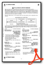
Chart Supplement

VFR Chart of PASA
Sectional Charts at SkyVector.com
IFR Chart of PASA
Enroute Charts at SkyVector.com
Location Information for PASA
Coordinates: N63°41.18' / W170°29.59'Located 01 miles SW of Savoonga, Alaska on 834 acres of land. View all Airports in Alaska.
Surveyed Elevation is 59 feet MSL.
Operations Data
|
|
Airport Communications
| AWOS-3P: | 121.3 Tel. 907-560-7600 |
|---|---|
| CTAF: | 122.700 |
| AWOS-3P at GAM (33.3 W): | 125.9 907-560-7605 |
- APCH/DEP SVC PRVDD BY ANCHORAGE ARTCC ON FREQS 132.2/281.4 (GAMBELL RCAG).
- COMMUNICATIONS PRVDD BY NOME FSS ON FREQ 122.3 (SAVOONGA RCO).
Nearby Navigation Aids
|
| ||||||||||||||||||||||||||||||


Runway 05/23
| Dimensions: | 4400 x 100 feet / 1341 x 30 meters | |
|---|---|---|
| Surface: | Gravel in Good Condition -5 IN ROCKS ALG BOTH EDGES. | |
| Edge Lighting: | Medium Intensity | |
| Runway 05 | Runway 23 | |
| Coordinates: | N63°40.99' / W170°30.29' | N63°41.36' / W170°28.89' |
| Elevation: | 59.0 | 54.7 |
| Traffic Pattern: | Left | Right |
| Runway Heading: | 60° True | 240° True |
| Markings: | Non-Standard | Non-Standard |
| Glide Slope Indicator | V4L (3.00° Glide Path Angle) | V4L (3.00° Glide Path Angle) |
| Obstacles: | 15 ft Road 0 ft from runway, 70 ft right of center CTLG OBSTN EXCEEDS 45 DEG SLOPE. |
15 ft Road 0 ft from runway, 70 ft left of center |
Ownership Information
| Ownership: | Publicly owned | |
|---|---|---|
| Owner: | ALASKA DOT&PF NORTHERN REGION | |
| 2301 PEGER RD | ||
| FAIRBANKS, AK 99709 | ||
| 907-451-2200 | ||
| Manager: | GEORGE KOST | |
| PO BOX 1048 | ||
| NOME, AK 99762 | ||
| 907-443-2500 | ||
Other Remarks
- S EDGE SAFETY AREA USED AS ROAD.
- RWY COND UNMNT; RCMD VISUAL INSP BFR LNDG.
- WX CAMERA AVBL ON INTERNET AT HTTPS://WEATHERCAMS.FAA.GOV
- 148 FT WIND TURBINES 0.34 MI NNW.
- ORANGE DRUMS; ALIGNED W CNTRLN; EXTD 2500 FT SW.
- ORANGE DRUMS; ALIGNED W CNTRLN; EXTD 2500 FT SW.
- ACTVT MIRL RWY 05/23 - CTAF. VASI RWY 05 & 23 OPR CONSLY.
Weather Minimums

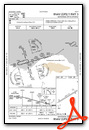
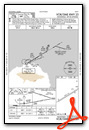
Instrument Approach Procedure (IAP) Charts

Nearby Airports with Instrument Procedures
| ID | Name | Heading / Distance | ||
|---|---|---|---|---|
 |
PAGM | Gambell Airport | 278° | 33.4 |
|
PAIW | Wales Airport | 026° | 131.9 |
Airport Images
Do you have a recent image of this airport? Upload it here!


