Login
Register


GMMN
Casablanca/Mohammed V Airport
VFR Chart of GMMN
Sectional Charts at SkyVector.com
IFR Chart of GMMN
Enroute Charts at SkyVector.com
Location Information for GMMN
Coordinates: N33°21.85' / W7°34.90'View all Airports in Grand Casablanca, Morocco.
Elevation is 656.0 feet MSL.
Operations Data
|
|
Airport Communications
| MOHAMMED V APPROACH Approach: | 119.90 |
|---|---|
| MOHAMMED V APPROACH Approach: | 121.30 |
| MOHAMMED V ATIS: | 126.30 |
| MOHAMMED V Emergency: | 121.50 |
| MOHAMMED V GROUND Ground Control: | 121.70 |
| MOHAMMED V GROUND Ground Control: | 130.60 |
| MOHAMMED V TOWER Tower: | 118.50 |
| MOHAMMED V TOWER Tower: | 121.00 |
Nearby Navigation Aids
|
| ||||||||||||||||||||||||||||||||||||||||||||||||||||||||||||


Runway 17L/35R
| Dimensions: | 12195 x 148 feet / 3717 x 45 meters | |
|---|---|---|
| Surface: | Hard | |
| Runway 17L | Runway 35R | |
| Coordinates: | N33°23.04' / W7°35.61' | N33°21.11' / W7°34.95' |
| Elevation: | 633 | 656 |
| Runway Heading: | 165° | 345° |
Runway 17R/35L
| Dimensions: | 12175 x 148 feet / 3711 x 45 meters | |
|---|---|---|
| Surface: | Unknown | |
| Runway 17R | Runway 35L | |
| Coordinates: | N33°22.98' / W7°35.85' | N33°21.05' / W7°35.19' |
| Elevation: | 640 | 656 |
| Runway Heading: | 165° | 345° |
Nearby Airports with Instrument Procedures
| ID | Name | Heading / Distance | ||
|---|---|---|---|---|
 |
GMMB | Benslimane National Airport | 045° | 24.9 |
|
GMME | Rabat-Sale Airport | 045° | 58.5 |
|
GMMD | Beni Mellal Airport | 131° | 86.1 |
|
GMMX | Marrakech Airport | 192° | 107.7 |
|
GMFI | Ifrane Airport | 085° | 122.3 |
|
GMFF | Fes Saiss International Airport | 074° | 134.7 |
|
GMMI | Essaouira/Mogador International Airport | 222° | 158.9 |
Airport Images
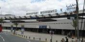
By: makine


