Login
Register


IYK
Inyokern Airport
Official FAA Data Effective 2026-02-19 0901Z
Chart Supplement

VFR Chart of KIYK
Sectional Charts at SkyVector.com
IFR Chart of KIYK
Enroute Charts at SkyVector.com
Location Information for KIYK
Coordinates: N35°39.52' / W117°49.77'Located 01 miles NW of Inyokern, California on 1640 acres of land. View all Airports in California.
Surveyed Elevation is 2457 feet MSL.
Operations Data
|
|
Airport Communications
| JOSHUA APPROACH: | 133.65 348.7 |
|---|---|
| JOSHUA DEPARTURE: | 133.65 348.7 |
| CTAF: | 122.800 |
| UNICOM: | 122.800 |
| ATIS at NID (6.7 E): | 322.375 |
| AWOS-1 at L71 (31.7 S): | 120.875 760-373-7670 |
| AWOS-3PT at MHV (39.2 SW): | 132.225 661-824-5218 |
Nearby Navigation Aids
|
| ||||||||||||||||||||||||||||||||||||||||||


Runway 15/33
| Dimensions: | 7100 x 75 feet / 2164 x 23 meters | |
|---|---|---|
| Surface: | Asphalt in Fair Condition PAVEMENT EXPERIENCING LONGL AND LATERAL BLOCK CRACKING ON PTNS OF RWY. | |
| Weight Limits: | 7 /F/C/Y/U, S-24 | |
| Edge Lighting: | Medium Intensity | |
| Runway 15 | Runway 33 | |
| Coordinates: | N35°40.02' / W117°50.06' | N35°38.89' / W117°49.71' |
| Elevation: | 2454.9 | 2428.8 |
| Traffic Pattern: | Left | Left |
| Runway Heading: | 166° True | 346° True |
| Markings: | Basic in good condition. | Basic in good condition. |
| Glide Slope Indicator | P2L (3.00° Glide Path Angle) | P2L (3.30° Glide Path Angle) |
Runway 02/20
| Dimensions: | 6275 x 75 feet / 1913 x 23 meters | |
|---|---|---|
| Surface: | Asphalt in Good Condition | |
| Weight Limits: | 6 /F/C/X/U, S-30, D-50, ST-80 | |
| Edge Lighting: | Medium Intensity | |
| Runway 02 | Runway 20 | |
| Coordinates: | N35°38.90' / W117°50.00' | N35°39.78' / W117°49.35' |
| Elevation: | 2441.6 | 2413.7 |
| Traffic Pattern: | Left | Right |
| Runway Heading: | 31° True | 211° True |
| Displaced Threshold: | 320 Feet | |
| Markings: | Non-Precision Instrument in good condition. | Non-Precision Instrument in good condition. |
| Glide Slope Indicator | P2L (3.30° Glide Path Angle) | V4L (3.00° Glide Path Angle) |
Runway 10/28
| Dimensions: | 4150 x 75 feet / 1265 x 23 meters | |
|---|---|---|
| Surface: | Asphalt in Poor Condition POOR BUT STABLE. PTNS OF RWY CTRLN MARKING OBSCD BY CRACK FILLER. | |
| Weight Limits: | 7 /F/C/Y/U, S-24 | |
| Edge Lighting: | Medium Intensity | |
| Runway 10 | Runway 28 | |
| Coordinates: | N35°40.07' / W117°50.10' | N35°39.77' / W117°49.35' |
| Elevation: | 2456.7 | 2413.3 |
| Traffic Pattern: | Left | Left |
| Runway Heading: | 115° True | 295° True |
| Displaced Threshold: | 103 Feet | |
| Markings: | Numbers Only in fair condition. | Numbers Only in fair condition. |
Services Available
| Fuel: | 100LL (blue), Jet-A |
|---|---|
| Transient Storage: | Hangars,Tiedowns |
| Airframe Repair: | MINOR |
| Engine Repair: | MINOR |
| Bottled Oxygen: | NOT AVAILABLE |
| Bulk Oxygen: | NOT AVAILABLE |
| Other Services: | AIR FREIGHT SERVICES,GLIDER SERVICE,PILOT INSTRUCTION,GLIDER TOWING SERVICES |
Ownership Information
| Ownership: | Publicly owned | |
|---|---|---|
| Owner: | INDIAN WELLS VALLEY APT DIST | |
| P.O. BOX 634 | ||
| INYOKERN, CA 93527 | ||
| 760-377-5844 | ||
| Manager: | SCOTT A. SEYMOUR | AIRPORT DIRECTOR. EMAIL: SCOTT@INYOKERNAIRPORT.COM |
| 1669 AIRPORT ROAD | ||
| INYOKERN, CA 93527 | ||
| 760-377-5844 | ||
Other Remarks
- THIS AIRPORT HAS BEEN SURVEYED BY THE NATIONAL GEODETIC SURVEY.
- RY 02/20 & 15/33 HAVE DSTC RMNG SIGNS.
- FREQUENT GLIDER OPNS ON WEEKENDS.
- FOR CD CTC LOS ANGELES ARTCC AT 661-575-2079.
- 0LL AFTER 1600 CALLOUT FEE FOR SVC CALL (760) 382-3383.
- ACTVT VASI RWY 20; MIRL RWYS 02/20, 10/28, 15/33 - CTAF. PAPI RWYS 02, 15 & 33 OPR CONSLY.
- AUTOMATED UNICOM - 3 CLICKS FOR ARPT ADVISORY & WEATHER OR DIAL 617-262-3825, 4 CLICKS FOR RADIO CHECK.
Weather Minimums

Instrument Approach Procedure (IAP) Charts
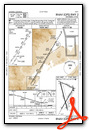
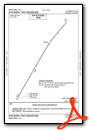
Departure Procedure (DP) Charts
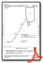
Departure Procedure Obstacles (DPO) Charts
Nearby Airports with Instrument Procedures
| ID | Name | Heading / Distance | ||
|---|---|---|---|---|
 |
L71 | California City Municipal Airport | 196° | 31.8 |
|
KMHV | Mojave Air & Space Port/Rutan Field Airport | 203° | 39.2 |
|
KEDW | Edwards AFB Airport | 183° | 45.1 |
|
KWJF | General Wm J Fox Airfield Airport | 199° | 58.2 |
|
L45 | Bakersfield Municipal Airport | 251° | 60.6 |
|
KBFL | Meadows Field Airport | 257° | 61.6 |
|
KPMD | Palmdale Usaf Plant 42 Airport | 191° | 62.9 |
|
KPTV | Porterville Municipal Airport | 290° | 64.1 |
|
KMIT | Shafter-Minter Field Airport | 262° | 67.3 |
|
KVCV | Southern California Logistics Airport | 160° | 67.4 |
|
KDLO | Delano Municipal Airport | 274° | 68.9 |
|
KDAG | Barstow-Daggett Airport | 132° | 70.4 |
Airport Images
Do you have a recent image of this airport? Upload it here!


