Login
Register


VCV
Southern California Logistics Airport
Official FAA Data Effective 2026-02-19 0901Z
Chart Supplement

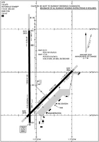
KVCV Airport Diagram
VFR Chart of KVCV
Sectional Charts at SkyVector.com
IFR Chart of KVCV
Enroute Charts at SkyVector.com
Location Information for KVCV
Coordinates: N34°35.73' / W117°22.96'Located 05 miles NW of Victorville, California on 2300 acres of land. View all Airports in California.
Surveyed Elevation is 2885 feet MSL.
Operations Data
|
|
Airport Communications
| ATIS: | 135.475 |
|---|---|
| AWOS-3: | 135.475 Tel. 760-246-3635 |
| VICTORVILLE TOWER: | 118.35 282.225 |
| VICTORVILLE GROUND: | 124.45 |
| JOSHUA APPROACH: | 124.55 363.0 |
| JOSHUA DEPARTURE: | 124.55 363.0 |
| EMERG: | 121.5 |
| CTAF: | 118.350 |
| ASOS at GXA (14.3 W): | 413.2 760-315-0639 |
| AWOS-3 at SBD (30.9 S): | 909-382-0067 |
| D-ATIS at SBD (30.9 S): | 124.175 |
Nearby Navigation Aids
|
| ||||||||||||||||||||||||||||||||||||||||||


Runway 17/35
| Dimensions: | 13052 x 150 feet / 3978 x 46 meters | |
|---|---|---|
| Surface: | Asphalt-Concrete / Grooved in Good Condition | |
| Weight Limits: | S-60, D-200, ST-400, DT-850
PCR VALUE: 473/F/A/W/U
| |
| Edge Lighting: | High Intensity | |
| Runway 17 | Runway 35 | |
| Coordinates: | N34°36.97' / W117°23.20' | N34°34.82' / W117°23.18' |
| Elevation: | 2821.5 | 2885.3 |
| Traffic Pattern: | Right | Left |
| Runway Heading: | 180° True | 360° True |
| Declared Distances: | TORA:13052 TODA:13052 ASDA:13052 LDA:13052 | TORA:13052 TODA:13052 ASDA:13052 LDA:13052 |
| Markings: | Non-Precision Instrument in good condition. | Precision Instrument in good condition. |
| Glide Slope Indicator | P4L (3.00° Glide Path Angle) | P4L (3.00° Glide Path Angle) |
| RVR Equipment | Touchdown | Rollout |
| REIL: | Yes | Yes |
Runway 03/21
| Dimensions: | 9138 x 150 feet / 2785 x 46 meters | |
|---|---|---|
| Surface: | Asphalt-Concrete in Good Condition | |
| Edge Lighting: | High Intensity | |
| Runway 03 | Runway 21 | |
| Coordinates: | N34°34.96' / W117°23.27' | N34°36.04' / W117°21.99' |
| Elevation: | 2877.8 | 2844.2 |
| Traffic Pattern: | Right | |
| Runway Heading: | 45° True | 225° True |
| Declared Distances: | TORA:9138 TODA:9138 ASDA:9138 LDA:9138 | TORA:9138 TODA:9138 ASDA:9138 LDA:9138 |
| Markings: | Non-Precision Instrument in good condition. | Non-Precision Instrument in good condition. |
| Glide Slope Indicator | P4L (3.00° Glide Path Angle) | P4L (3.00° Glide Path Angle) |
Services Available
| Fuel: | 100LL (blue), Jet-A |
|---|---|
| Transient Storage: | Tiedowns |
| Airframe Repair: | MAJOR |
| Engine Repair: | MAJOR |
| Bottled Oxygen: | NOT AVAILABLE |
| Bulk Oxygen: | NOT AVAILABLE |
| Other Services: | AIR FREIGHT SERVICES,AIR AMBULANCE SERVICES,CARGO HANDLING SERVICES |
Ownership Information
| Ownership: | Publicly owned | |
|---|---|---|
| Owner: | SOUTHERN CA LOGISTICS ARPT AUTH | |
| 18374 PHANTOM | ||
| VICTORVILLE, CA 92394 | ||
| 760-243-1900 | ||
| Manager: | JAMES MURAWSKI | AIRPORT OPERATIONS - 760 243-1915 |
| SO CAL LOGISTICS AIRPORT AUTHORITY, 18374 PHANTOM WEST | ||
| VICTORVILLE, CA 92394 | ||
| 760-243-1915 | ||
Other Remarks
- AVOID OVERFLIGHT OF SILVER LAKES 10 MILES NORTH FOR NOISE ABATEMENT.
- PTN OF TWY A BTN TWY C AND RWY 21, PTN OF TWY C BTN TWY A AND TWY B, PTN OF TWY C BTN TWYS C1 AND C2, PTN OF TWY E BTN TWY E1 AND TWY D, RWY 17 THLD, AND RWY 35 THLD ARE NOT VISIBLE AREAS FROM THE ATCT. VCV ATCT UNA TO PRVD ATC SVCS TO ACFT IN THESE NON-VISIBLE AREAS.
- TWY U NOT AVBL FOR GA OR ACR USE. NOT LGTD.
- PTN OF RWY 17 NORTH 3000 FT ARE NOT VISIBLE AREAS FROM TOWER.
- WHEN ATCT CLSD, FOR CD CTC JOSHUA APCH AT 661-277-3843.
- FOR ACFT FUEL OR MAINT CALL (760) 246-7794 OR USE FREQ 131.975
- WHEN ATCT CLSD ACTVT PAPI RWY 03, 21, 17 & 35; HIRL RWYS 03/21 & 17/35 - CTAF.
- OPR HRS 2200-0600.
- U.S. CUSTOMS USER FEE ARPT. CUSTOMS OFFICER AVBL 1700-0100Z++ MON-FRI 760-243-1925, AFTER HRS CALL 760-490-8651.
Weather Minimums

Instrument Approach Procedure (IAP) Charts


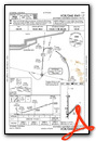
Nearby Airports with Instrument Procedures
| ID | Name | Heading / Distance | ||
|---|---|---|---|---|
 |
KAPV | Apple Valley Airport | 097° | 9.8 |
|
KSBD | San Bernardino International Airport | 166° | 30.8 |
|
KEDW | Edwards AFB Airport | 307° | 31.1 |
|
KCCB | Cable Airport | 207° | 32.7 |
|
KREI | Redlands Municipal Airport | 158° | 32.7 |
|
L35 | Big Bear City Airport | 127° | 32.8 |
|
KDAG | Barstow-Daggett Airport | 062° | 33.3 |
|
KONT | Ontario International Airport | 198° | 34.1 |
|
KPMD | Palmdale Usaf Plant 42 Airport | 273° | 34.8 |
|
KPOC | Brackett Field Airport | 213° | 36.1 |
|
KRIR | Flabob Airport | 182° | 36.4 |
|
KRAL | Riverside Airport | 184° | 38.7 |
Airport Images

By: www.focalflight.com

By: adh


