


Login
Register
IZA
Santa Ynez/Kunkle Field Airport
Official FAA Data Effective 2026-10-01 0901Z
Chart Supplement

VFR Chart of KIZA
Sectional Charts at SkyVector.com
IFR Chart of KIZA
Enroute Charts at SkyVector.com
Location Information for KIZA
Coordinates: N34°36.41' / W120°4.53'Located 01 miles SE of Santa Ynez, California on 125 acres of land. View all Airports in California.
Surveyed Elevation is 674 feet MSL.
Operations Data
|
|
Airport Communications
| AWOS-3PT: | 118.075 Tel. 805-686-5325 |
|---|---|
| SANTA BARBARA APPROACH: | 124.15 327.8 |
| SANTA BARBARA DEPARTURE: | 124.15 327.8 |
| CTAF: | 122.800 |
| UNICOM: | 122.800 |
| AWOS-3 at HUG (14.6 S): | 119.625 805-961-4256 |
| ATIS at SBA (15.9 SE): | 132.65 |
| ASOS at SBA (15.9 SE): | 805-957-6133 |
- APCH/DEP CTL SVC PRVDD BY LOS ANGELES ARTCC (ZLA) ON FREQS 119.05/269.5 (SAN LUIS OBISPO RCAG) WHEN SANTA BARBARA APCH CTL (SBA) CLSD.
Nearby Navigation Aids
|
| ||||||||||||||||||||||||||||||||||||


Runway 08/26
| Dimensions: | 2803 x 75 feet / 854 x 23 meters | |
|---|---|---|
| Surface: | Asphalt in Good Condition | |
| Weight Limits: | S-12 | |
| Edge Lighting: | Medium Intensity | |
| Runway 08 | Runway 26 | |
| Coordinates: | N34°36.44' / W120°4.81' | N34°36.38' / W120°4.26' |
| Elevation: | 655.0 | 674.3 |
| Traffic Pattern: | Right | Left |
| Runway Heading: | 98° True | 278° True |
| Markings: | Non-Precision Instrument in good condition. | Basic in fair condition. |
| Glide Slope Indicator | P2L (3.00° Glide Path Angle) | P2L (3.00° Glide Path Angle) |
| REIL: | Yes | Yes |
| Obstacles: | 17 ft Hill 750 ft from runway, 150 ft left of center | |
Services Available
| Fuel: | 100LL (blue), Jet-A |
|---|---|
| Transient Storage: | Tiedowns |
| Airframe Repair: | NONE |
| Engine Repair: | NONE |
| Bottled Oxygen: | NONE |
| Bulk Oxygen: | NONE |
| Other Services: | CHARTER SERVICE,GLIDER SERVICE,PILOT INSTRUCTION,AIRCRAFT RENTAL,GLIDER TOWING SERVICES |
Ownership Information
| Ownership: | Publicly owned | |
|---|---|---|
| Owner: | COUNTY OF SANTA BARBARA | |
| 123 EAST ANAPAMU, P.O. BOX 91610 | ||
| SANTA BARBARA, CA 93190-1610 | ||
| 805-568-3037 | ||
| Manager: | DAVE ROMERO | |
| 900 AIRPORT ROAD, P.O. BOX 1572 | ||
| SANTA YNEZ, CA 93460 | ||
| 805-688-8390 | ||
Other Remarks
- RWY 26 TKOF RCMD HDG 210 DEG AT ARPT PERIMETER IF SAFETY PMT FOR NOISE ABATEMENT.
- GLIDER OPNS ON DIRT APCH ZONE RWY 26; GLIDERS OPERG RIGHT TFC RWY 26.
- ULTRALIGHT OPNS SOUTH OF RWY 08/26.
- HELICOPTERS APCH FROM NORTH & SOUTH ON EAST END OF ARPT
- FOR CD CTC LOS ANGELES ARTCC AT 661-575-2079.
- 0LL FUEL AVBL 24 HRS USING AUTOMATED SYSTEM.
- MIRL RWY 08/26 PRESET LOW INTST; TO INCR INTST & ACTVT REIL RWY 08 & 26; TWY LGTS - CTAF. PAPI RWY 08 & 26 OPR CONSLY.
Weather Minimums


Instrument Approach Procedure (IAP) Charts


Nearby Airports with Instrument Procedures
| ID | Name | Heading / Distance | ||
|---|---|---|---|---|
 |
KSBA | Santa Barbara Municipal Airport | 132° | 15.9 |
|
KLPC | Lompoc Airport | 280° | 19.7 |
|
KSMX | Santa Maria Pub/Capt G Allan Hancock Field Airport | 312° | 25.8 |
|
KVBG | Vandenberg Space Force Base Airport | 287° | 26.4 |
|
KSBP | San Luis Obispo County Regional Airport | 323° | 47.0 |
|
KOXR | Oxnard Airport | 119° | 49.5 |
|
KCMA | Camarillo Airport | 115° | 54.1 |
|
KNTD | Point Mugu NAS (Naval Base Ventura Co) Airport | 121° | 55.7 |
|
L45 | Bakersfield Municipal Airport | 050° | 68.4 |
|
KMIT | Shafter-Minter Field Airport | 038° | 69.3 |
|
KPRB | Paso Robles Municipal Airport | 337° | 69.4 |
|
KBFL | Meadows Field Airport | 045° | 70.5 |
Airport Images
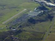
By: bfisher

By: bfisher



