Login
Register


JFX
Walker County/Bevill Field Airport
Official FAA Data Effective 2026-01-22 0901Z
Chart Supplement

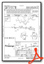
VFR Chart of KJFX
Sectional Charts at SkyVector.com
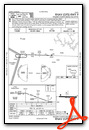
IFR Chart of KJFX
Enroute Charts at SkyVector.com
Location Information for KJFX
Coordinates: N33°54.12' / W87°18.83'Located 05 miles NW of Jasper, Alabama on 297 acres of land. View all Airports in Alabama.
Surveyed Elevation is 482 feet MSL.
Operations Data
|
|
Airport Communications
| AWOS-3PT: | 119.225 Tel. 205-295-5539 |
|---|---|
| BIRMINGHAM APPROACH: | 127.675 338.2 |
| BIRMINGHAM DEPARTURE: | 127.675 338.2 |
| CTAF: | 123.075 |
| UNICOM: | 123.075 |
| AWOS-3PT at 1M4 (26.9 NW): | 119.525 205-486-0035 |
| AWOS-3PT at CMD (31.7 NE): | 124.175 256-775-7476 |
| ATIS at BHM (34.6 SE): | 119.4 |
Nearby Navigation Aids
|
| ||||||||||||||||||||||||||||||||||||||||||||||||||||||


Runway 09/27
| Dimensions: | 5004 x 100 feet / 1525 x 30 meters | |
|---|---|---|
| Surface: | Asphalt in Fair Condition | |
| Weight Limits: | S-50 | |
| Edge Lighting: | Medium Intensity | |
| Runway 09 | Runway 27 | |
| Coordinates: | N33°54.13' / W87°19.32' | N33°54.11' / W87°18.34' |
| Elevation: | 482.3 | 473.8 |
| Runway Heading: | 92° True | 272° True |
| Displaced Threshold: | 190 Feet | |
| Declared Distances: | TORA:5001 TODA:5001 ASDA:4800 LDA:4800 | TORA:5001 TODA:5001 ASDA:5001 LDA:4800 |
| Markings: | Non-Precision Instrument in fair condition. | Precision Instrument in fair condition. |
| Glide Slope Indicator | V4L (3.00° Glide Path Angle) | V4L (3.00° Glide Path Angle) |
| REIL: | Yes | Yes |
| Obstacles: | 11 ft Trees 230 ft from runway, 202 ft left of center | 21 ft Trees 705 ft from runway, 64 ft right of center |
Services Available
| Fuel: | 100LL (blue), Jet-A, Jet A-1 |
|---|---|
| Transient Storage: | Tiedowns |
| Airframe Repair: | MAJOR NO OUTSIDE WORK EXCP EMERGS. |
| Engine Repair: | MAJOR NO OUTSIDE WORK EXCP EMERGS. |
| Bottled Oxygen: | NONE |
| Bulk Oxygen: | NONE |
| Other Services: | PILOT INSTRUCTION,AIRCRAFT RENTAL |
Ownership Information
| Ownership: | Publicly owned | |
|---|---|---|
| Owner: | WALKER COUNTY COMMISSION | STEVE MILLER, CHAIRMAN. MIKE SHORT, CO ENGR, KEITH DUNCAN, ARPT MGR. |
| 1801 3RD AVE. S., SUITE 113 | ||
| JASPER, AL 35501 | ||
| 205-384-7230 | ||
| Manager: | KEITH DUNCAN | |
| 198 BIDDLE DRIVE | ||
| JASPER, AL 35503 | ||
| 205-388-1294 | ||
Other Remarks
- THIS AIRPORT HAS BEEN SURVEYED BY THE NATIONAL GEODETIC SURVEY.
- DEER ON & INVOF RWYS.
- GCO AVBL ON FREQ 121.725 THRU BIRMINGHAM (BHM) CLEARANCE DELIVERY.
- FOR CD IF UNA VIA GCO CTC BIRMINGHAM APCH AT 205-769-3890.
- HVY FLT STUDENT ACT.
- 0LL FUEL AVBL 24/7 WITH CC.
- ACTVT REIL RWY 9 & 27; VASI RWY 9 & 27; MIRL RWY 9/27- CTAF.
Weather Minimums

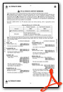
Instrument Approach Procedure (IAP) Charts


Nearby Airports with Instrument Procedures
| ID | Name | Heading / Distance | ||
|---|---|---|---|---|
 |
1M4 | Posey Field Airport | 327° | 26.8 |
|
M95 | Richard Arthur Field Airport | 245° | 27.6 |
|
KCMD | Cullman Regional/Folsom Field Airport | 045° | 31.6 |
|
KBHM | Birmingham-Shuttlesworth International Airport | 125° | 34.6 |
|
5M0 | Hartselle/Morgan County Regional Airport | 031° | 35.8 |
|
KHAB | Marion County-Rankin Fite Airport | 290° | 36.5 |
|
M22 | Bill Pugh Field Airport | 328° | 38.1 |
|
M55 | Lamar County Airport | 265° | 40.2 |
|
KEKY | Bessemer Ntl Airport | 151° | 40.3 |
|
KTCL | Tuscaloosa Ntl Airport | 200° | 43.4 |
|
9A4 | Courtland Airport | 357° | 45.3 |
|
3M8 | North Pickens Airport | 228° | 46.4 |
Airport Images
Do you have a recent image of this airport? Upload it here!


