Login
Register


CMD
Cullman Regional/Folsom Field Airport
Official FAA Data Effective 2026-01-22 0901Z
Chart Supplement

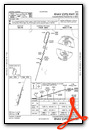
VFR Chart of KCMD
Sectional Charts at SkyVector.com
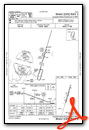
IFR Chart of KCMD
Enroute Charts at SkyVector.com
Location Information for KCMD
Coordinates: N34°16.12' / W86°51.48'Located 05 miles N of Cullman, Alabama on 90 acres of land. View all Airports in Alabama.
Surveyed Elevation is 969 feet MSL.
Operations Data
|
|
Airport Communications
| AWOS-3PT: | 124.175 Tel. 256-775-7476 |
|---|---|
| HUNTSVILLE APPROACH: | 118.05 239.0 |
| HUNTSVILLE DEPARTURE: | 118.05 239.0 |
| UNICOM: | 122.800 |
| CTAF: | 122.800 |
| ATIS at HSV (22.5 N): | 121.25 |
| ASOS at HSV (22.8 N): | 121.25 256-207-5925 |
| ASOS at DCU (23.5 N): | 118.375 256-350-4270 |
- APCH/DEP SVC PRVDD BY MEMPHIS ARTCC ON FREQS 120.8/307.0 (HUNTSVILLE RCAG) WHEN HUNTSVILLE APCH CTL CLSD.
Nearby Navigation Aids
|
| ||||||||||||||||||||||||||||||||||||||||||||||||||||||||||||


Runway 02/20
| Dimensions: | 5500 x 100 feet / 1676 x 30 meters | |
|---|---|---|
| Surface: | Asphalt / Grooved in Excellent Condition | |
| Weight Limits: | S-61, D-78, ST-130
PCR VALUE: 243/F/D/X/T
| |
| Edge Lighting: | Medium Intensity | |
| Runway 02 | Runway 20 | |
| Coordinates: | N34°15.69' / W86°51.64' | N34°16.56' / W86°51.33' |
| Elevation: | 934.4 | 969.6 |
| Traffic Pattern: | Left | Left |
| Runway Heading: | 17° True | 197° True |
| Markings: | Non-Precision Instrument in good condition. | Non-Precision Instrument in good condition. |
| Glide Slope Indicator | P2L (3.77° Glide Path Angle) | P2L (3.00° Glide Path Angle) |
| REIL: | Yes | Yes |
Services Available
| Fuel: | 100LL (blue), Jet-A, Jet A-1+ |
|---|---|
| Transient Storage: | Tiedowns |
| Airframe Repair: | NONE |
| Engine Repair: | NONE |
| Bottled Oxygen: | NONE |
| Bulk Oxygen: | NONE |
| Other Services: | PILOT INSTRUCTION,PARACHUTE JUMP ACTIVITY,AIRCRAFT RENTAL |
Ownership Information
| Ownership: | Publicly owned | |
|---|---|---|
| Owner: | CITY/COUNTY OF CULLMAN | |
| PO BOX 278 | ||
| CULLMAN, AL 35056 | ||
| 256-775-7102 | ||
| Manager: | BEN HARRISON | |
| 231 CO RD 1360 | ||
| VINEMONT, AL 35179 | ||
| 256-775-1011 | BHARRISON@CULLMANAL.GOV | |
Other Remarks
- EXTSV FLT TRNG WI ARPT AREA.
- TRML RESTAURANT OPR THU-SUN 0800-1400.
- FOR CD IF UNA VIA GCO, CTC HUNTSVILLE APCH AT 256-542-2099. WHEN APCH CLSD CTC MEMPHIS ARTCC AT 901-368-8453/8449.
- SKYDIVE OPNS DURG WKDAYS AND WKENDS.
- FOR SVC AFT HRS CALL (256) 531-6666.
- 0LL AVGAS (100LL) AVBL 24/7 WITH CC.
- ACTVT MIRL RWY 02/20 - CTAF. PAPI RWY 02 & 20 OPR CONSLY.
- DUSK-DAWN.
Weather Minimums

Instrument Approach Procedure (IAP) Charts
Nearby Airports with Instrument Procedures
| ID | Name | Heading / Distance | ||
|---|---|---|---|---|
 |
5M0 | Hartselle/Morgan County Regional Airport | 336° | 9.1 |
|
KHSV | Huntsville International-Carl T Jones Field Airport | 010° | 22.5 |
|
KDCU | Pryor Field Regional Airport | 349° | 23.5 |
|
20A | Robbins Field Airport | 126° | 29.7 |
|
KBFZ | Albertville Regional/Thomas J Brumlik Field Airport | 094° | 30.0 |
|
8A1 | Guntersville Municipal/Joe Starnes Field Airport | 074° | 30.8 |
|
KJFX | Walker County/Bevill Field Airport | 226° | 31.6 |
|
9A4 | Courtland Airport | 313° | 33.7 |
|
1M4 | Posey Field Airport | 271° | 36.9 |
|
KMDQ | Huntsville Exec Tom Sharp Jr Field Airport | 022° | 38.4 |
|
KGAD | Northeast Alabama Regional Airport | 114° | 42.2 |
|
KBHM | Birmingham-Shuttlesworth International Airport | 172° | 42.5 |
Fuel Providers

Airport Images
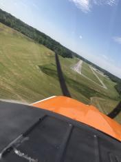
By: Big Orange Bird


