Login
Register
PIH
Pocatello Regional Airport
Official FAA Data Effective 2025-12-25 0901Z
VFR Chart of KPIH
Sectional Charts at SkyVector.com
IFR Chart of KPIH
Enroute Charts at SkyVector.com
Location Information for KPIH
Coordinates: N42°54.59' / W112°35.76'Located 07 miles NW of Pocatello, Idaho on 3374 acres of land. View all Airports in Idaho.
Surveyed Elevation is 4451 feet MSL.
Operations Data
|
|
Airport Communications
| ATIS: | 135.625 (208-232-2269) |
|---|---|
| ASOS: | 135.625 Tel. 208-278-2021 |
| POCATELLO TOWER: | 119.1 257.8 |
| POCATELLO GROUND: | 121.9 |
| UNICOM: | 122.950 |
| CTAF: | 119.100 |
| ATIS at IDA (42.9 NE): | 135.325 |
| ASOS at IDA (43.2 NE): | 208-524-4553 |
| ASOS at BYI (56.3 W): | 135.575 208-677-3604 |
- APCH/DEP SVC PRVDD BY SALT LAKE ARTCC (ZLC) ON FREQS 128.35/239.25 (BLACKFOOT RCAG).
Nearby Navigation Aids
|
| ||||||||||||||||||||||||||||||||||||||||||||||||
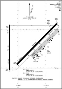
Runway 03/21
| Dimensions: | 9059 x 150 feet / 2761 x 46 meters | |
|---|---|---|
| Surface: | Asphalt / Porous Friction Course in Good Condition | |
| Weight Limits: | S-120, D-245, ST-428, DT-965
PCR VALUE: 615/F/B/X/T
| |
| Edge Lighting: | High Intensity | |
| Runway 03 | Runway 21 | |
| Coordinates: | N42°54.10' / W112°36.05' | N42°55.16' / W112°34.61' |
| Elevation: | 4442.2 | 4447.7 |
| Traffic Pattern: | Left | Left |
| Runway Heading: | 45° True | 225° True |
| Declared Distances: | TORA:9059 TODA:9059 ASDA:9059 LDA:9059 | TORA:9059 TODA:9059 ASDA:9059 LDA:9059 |
| Markings: | Non-Precision Instrument in good condition. | Precision Instrument in good condition. |
| Glide Slope Indicator | P4L (3.00° Glide Path Angle) | P4L (3.00° Glide Path Angle) |
| RVR Equipment | Touchdown | |
| Approach Lights: | MALSR 1,400 Foot Medium-intensity Approach Lighting System with runway alignment indicator lights. | |
| REIL: | Yes | |
Runway 17/35
| Dimensions: | 7150 x 100 feet / 2179 x 30 meters | |
|---|---|---|
| Surface: | Asphalt / Grooved in Good Condition | |
| Weight Limits: | S-120, D-245, ST-428, DT-965
PCR VALUE: 615/F/B/X/T
| |
| Edge Lighting: | Medium Intensity | |
| Runway 17 | Runway 35 | |
| Coordinates: | N42°55.12' / W112°36.29' | N42°53.95' / W112°36.29' |
| Elevation: | 4448.5 | 4443.7 |
| Traffic Pattern: | Left | Left |
| Runway Heading: | 180° True | 360° True |
| Declared Distances: | TORA:7150 TODA:7150 ASDA:7150 LDA:7150 | TORA:7150 TODA:7150 ASDA:7150 LDA:7150 |
| Markings: | Basic in fair condition. | Basic in fair condition. |
| Glide Slope Indicator | P4L (3.00° Glide Path Angle) | P4L (3.00° Glide Path Angle) |
| REIL: | Yes | |
| Obstacles: | 42 ft Pole 2030 ft from runway, 50 ft right of center | |
Services Available
| Fuel: | 100LL (blue), Jet A-1, Jet A-1+ |
|---|---|
| Transient Storage: | Hangars,Tiedowns |
| Airframe Repair: | MAJOR |
| Engine Repair: | MAJOR |
| Bottled Oxygen: | HIGH/LOW |
| Bulk Oxygen: | NOT AVAILABLE |
| Other Services: | AIR FREIGHT SERVICES,CARGO HANDLING SERVICES,CHARTER SERVICE,PILOT INSTRUCTION,AIRCRAFT RENTAL |
Ownership Information
| Ownership: | Publicly owned | |
|---|---|---|
| Owner: | CITY OF POCATELLO | |
| P.O. BOX 4169 | ||
| POCATELLO, ID 83205-4169 | ||
| 208-234-6163 | ||
| Manager: | ALAN EVANS | |
| P. O. BOX 4169 | ||
| POCATELLO, ID 83205-4169 | ||
| 208-234-6154 | ||
Other Remarks
- FLOCKS OF WATERFOWL IN VCNTY ARPT.
- RADIO CONTROLLED ACFT 1 MI E OF ARPT BLO 400 FT AGL.
- TWY 'G' HAS NO EDGE LIGHTS OR REFLECTORS, RESTRICTED TO DAY USE ONLY.
- AFLD COND UNMON 2330-0600 DLY EXC ACR OPNS AND 24-HR PPR 208-234-6154 OR 208-241-7949. ADNL FEES APPLY.
- FOR CD IF UNA TO CTC ON FSS FREQ, CTC SALT LAKE ARTCC AT 801-320-2568.
- 0LL FBO MONITORS 122.95 & 123.0.
- AFT ATCT CLSD ACTVT MALSR RWY 21; REIL RWY 17 & 03; PAPI RWY 21, 17 & 35; MIRL RWY 17/35; HIRL RWY 03/21 - CTAF. PAPI RWY 03 OPR CONSLY.
Weather Minimums
Instrument Approach Procedure (IAP) Charts
Departure Procedure Obstacles (DPO) Charts
Nearby Airports with Instrument Procedures
| ID | Name | Heading / Distance | ||
|---|---|---|---|---|
 |
U02 | Mccarley Field Airport | 031° | 21.0 |
 |
KIDA | Idaho Falls Regional Airport | 032° | 42.9 |
 |
KAOC | Arco-Butte County Airport | 322° | 52.7 |
 |
KBYI | Burley Municipal Airport | 247° | 56.5 |
 |
KRXE | Rexburg-Madison County Airport | 031° | 65.4 |
 |
1U7 | Bear Lake County Airport | 125° | 68.3 |
 |
KAFO | Afton Lincoln County/General Boyd L Eddins Field Airport | 098° | 74.0 |
 |
KLGU | Logan-Cache Airport | 153° | 74.8 |
 |
KSUN | Friedman Memorial Airport | 296° | 82.7 |
 |
KJER | Jerome County Airport | 263° | 82.9 |
 |
KDIJ | Driggs/Reed Memorial Airport | 052° | 82.8 |
 |
KBMC | Brigham City Regional Airport | 163° | 84.7 |


