Login
Register


KTS
Brevig Mission Airport
Official FAA Data Effective 2026-02-19 0901Z
Chart Supplement

VFR Chart of PFKT
Sectional Charts at SkyVector.com
IFR Chart of PFKT
Enroute Charts at SkyVector.com
Location Information for PFKT
Coordinates: N65°19.88' / W166°27.94'Located 00 miles E of Brevig Mission, Alaska on 344 acres of land. View all Airports in Alaska.
Surveyed Elevation is 38 feet MSL.
Operations Data
|
|
Airport Communications
| AWOS-3P: | 121.550 Tel. 907-642-2166 |
|---|---|
| CTAF: | 123.000 |
| AWOS-3P at TER (6.2 SE): | 118.375 907-642-2301 |
| AWOS-3 at TNC (38.9 W): | |
| AWOS-3P at IWK (44.2 NW): | 118.525 907-664-3907 |
- APCH/DEP SVC PRVDD BY ANCHORAGE ARTCC ON FREQS 133.3/290.4 (NOME RCAG).
- COMMUNICATIONS PRVDD BY NOME FSS ON FREQ 135.6 (BREVIG MISSION RCO).
Nearby Navigation Aids
|
| ||||||||||||||||||||||||||||||||||||||||||


Runway 12/30
| Dimensions: | 2990 x 100 feet / 911 x 30 meters | |
|---|---|---|
| Surface: | Gravel in Good Condition | |
| Edge Lighting: | Medium Intensity | |
| Runway 12 | Runway 30 | |
| Coordinates: | N65°20.01' / W166°28.31' | N65°19.69' / W166°27.41' |
| Elevation: | 36.5 | 34.8 |
| Runway Heading: | 130° True | 310° True |
| Markings: | Non-Standard | |
| Obstacles: | 28 ft Pole 1011 ft from runway, 401 ft left of center | |
Runway 05/23
| Dimensions: | 2110 x 75 feet / 643 x 23 meters | |
|---|---|---|
| Surface: | Gravel in Good Condition | |
| Edge Lighting: | Medium Intensity | |
| Runway 05 | Runway 23 | |
| Coordinates: | N65°19.82' / W166°28.40' | N65°20.02' / W166°27.72' |
| Elevation: | 34.0 | 38.1 |
| Traffic Pattern: | Left | Left |
| Runway Heading: | 55° True | 235° True |
| Markings: | Non-Standard | |
| Obstacles: | 1215 ft Hill 9500 ft from runway | |
Ownership Information
| Ownership: | Publicly owned | |
|---|---|---|
| Owner: | ALASKA DOT&PF NORTHERN REGION | |
| 2301 PEGER RD | ||
| FAIRBANKS, AK 99701 | ||
| 907-451-2200 | ||
| Manager: | GEORGE KOST | |
| BOX 1048 | ||
| NOME, AK 99762 | ||
| 907-443-2500 | ||
Other Remarks
- THIS AIRPORT HAS BEEN SURVEYED BY THE NATIONAL GEODETIC SURVEY.
- RY COND NOT MONITORED; RCMD VISUAL INSPECTION PRIOR TO LDNG.
- RWY 05/23 MARKED WITH LIGHTS AND PLASTIC MARKERS.
- RWY 12/30 MARKED WITH LIGHTS AND PLASTIC MARKERS.
- ACTVT MIRL RWY 05/23 & 12/30 - CTAF.
Weather Minimums

Instrument Approach Procedure (IAP) Charts
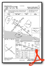

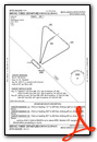
Departure Procedure Obstacles (DPO) Charts
Nearby Airports with Instrument Procedures
| ID | Name | Heading / Distance | ||
|---|---|---|---|---|
 |
PATE | Teller Airport | 149° | 6.3 |
|
PAIW | Wales Airport | 294° | 44.4 |
|
PAOM | Nome Airport | 151° | 55.8 |
|
PASH | Shishmaref Airport | 009° | 56.1 |
Airport Images
Do you have a recent image of this airport? Upload it here!


