Login
Register


KYU
Koyukuk Airport
Official FAA Data Effective 2026-01-22 0901Z
Chart Supplement

VFR Chart of PFKU
Sectional Charts at SkyVector.com
IFR Chart of PFKU
Enroute Charts at SkyVector.com
Location Information for PFKU
Coordinates: N64°52.55' / W157°43.83'Located 00 miles W of Koyukuk, Alaska on 287 acres of land. View all Airports in Alaska.
Estimated Elevation is 148 feet MSL.
Operations Data
|
|
Airport Communications
| CTAF: | 122.900 |
|---|---|
| AWOS-3P at NUL (12.4 SW): | 118.0 907-269-2774 |
| AWOS-3P at GAL (22.2 E): | 132.525 907-656-2483 |
| AWOS-3 at KAL (42.4 SW): | 135.25 907-621-7604 |
- APCH/DEP SVC PRVDD BY ANCHORAGE ARTCC ON FREQS 127.0/290.2 (GALENA RCAG).
- COMMUNICATIONS PRVDD BY FAIRBANKS FSS ON FREQ 122.2 (GALENA RCO).
Nearby Navigation Aids
|
| ||||||||||||||||||||||||

Runway 07/25
| Dimensions: | 4000 x 75 feet / 1219 x 23 meters | |
|---|---|---|
| Surface: | Gravel in Good Condition SOFT WHEN WET; RUTS & GRASS ENTIRE LEN. | |
| Edge Lighting: | Medium Intensity | |
| Runway 07 | Runway 25 | |
| Coordinates: | N64°52.49' / W157°44.58' | N64°52.61' / W157°43.07' |
| Elevation: | 148.7 | 148.9 |
| Traffic Pattern: | Left | Left |
| Runway Heading: | 79° True | 259° True |
| Markings: | Non-Standard in fair condition. | Non-Standard in fair condition. |
| Glide Slope Indicator | P4L (4.00° Glide Path Angle) | |
| REIL: | Yes | |
| Obstacles: | 30 ft Trees 0 ft from runway, 130 ft right of center | 24 ft Trees 0 ft from runway, 170 ft left of center |
Ownership Information
| Ownership: | Publicly owned | |
|---|---|---|
| Owner: | ALASKA DOT&PF NORTHERN REGION | |
| NORTHERN REGION, 2301 PEGER RD | ||
| FAIRBANKS, AK 99709 | ||
| (907) 451-5280 | ||
| Manager: | JASON LUNDINGTON | |
| 2301 PEGER RD | ||
| FAIRBANKS, AK 99709 | ||
| (907) 451-5280 | ||
Other Remarks
- THIS AIRPORT HAS BEEN SURVEYED BY THE NATIONAL GEODETIC SURVEY.
- SNOW REMOVAL OPS MNT CTAF.
- RWY COND UNMNT; RCMND VISUAL INSP PRIOR TO LNDG.
- COLD TEMPERATURE AIRPORT. ALTITUDE CORRECTION REQUIRED AT OR BELOW -47C.
- PLASTIC MKRS.
- PLASTIC MKRS.
- ACTVT PAPI RWY 07; REIL RWY 07; MIRL RWY 07/25 - CTAF.
- ACTVT ROTG BCN - CTAF.
Weather Minimums

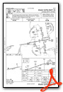
Instrument Approach Procedure (IAP) Charts

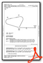
Departure Procedure Obstacles (DPO) Charts
Nearby Airports with Instrument Procedures
| ID | Name | Heading / Distance | ||
|---|---|---|---|---|
 |
PANU | Nulato Airport | 225° | 12.5 |
|
PAGA | Edward G Pitka Sr Airport | 112° | 22.1 |
|
PAKV | Kaltag Airport | 218° | 42.5 |
|
PARY | Ruby Airport | 097° | 58.7 |
|
PAHL | Huslia Airport | 034° | 60.5 |
|
PASK | Selawik Airport | 332° | 117.9 |
|
PAMC | Mc Grath Airport | 153° | 128.7 |
|
PAGX | Grayling Airport | 208° | 134.5 |
Airport Images
Do you have a recent image of this airport? Upload it here!


