Login
Register


LFHU
Lalpe Dhuez Airport
VFR Chart of LFHU
Sectional Charts at SkyVector.com
IFR Chart of LFHU
Enroute Charts at SkyVector.com
Location Information for LFHU
Coordinates: N45°5.25' / E6°5.02'View all Airports in Rhône-Alpes, France.
Elevation is 6103.0 feet MSL.
Operations Data
|
|
Nearby Navigation Aids
|
| ||||||||||||||||||||||||||||||||||||||||||||||||||||||||||||


Runway 06/24
| Dimensions: | 1470 x 98 feet / 448 x 30 meters | |
|---|---|---|
| Surface: | Unknown | |
| Runway 06 | Runway 24 | |
| Coordinates: | N45°5.18' / E6°4.87' | N45°5.30' / E6°5.16' |
| Elevation: | 5945 | 6103 |
| Runway Heading: | 059° | 239° |
Nearby Airports with Instrument Procedures
| ID | Name | Heading / Distance | ||
|---|---|---|---|---|
 |
LFLB | Chambery Aix Les Bains Airport | 345° | 34.2 |
|
LFLS | Grenoble Alpes Isere Airport | 297° | 35.9 |
|
LFLU | Valence Chabeuil Airport | 258° | 48.6 |
|
LFLP | Annecy Meythet Airport | 001° | 50.6 |
|
LFLL | Lyon Saint Exupery Airport | 312° | 57.1 |
|
LFLY | Lyon Bron Airport | 308° | 61.8 |
|
LIMF | Torino/Caselle Airport | 083° | 66.9 |
|
LIMW | Aosta Airport | 053° | 66.9 |
|
LSGG | Geneve Airport | 000° | 69.1 |
|
LIMZ | Cuneo/Levaldigi Airport | 115° | 73.3 |
|
LFMO | Orange Caritat Airport | 222° | 77.1 |
|
LFMH | Saint Etienne Loire Airport | 290° | 80.2 |
Airport Images
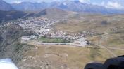
By: maximeguillaud


