Login
Register


LIMW
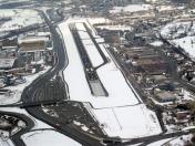
Aosta Airport
VFR Chart of LIMW
Sectional Charts at SkyVector.com
IFR Chart of LIMW
Enroute Charts at SkyVector.com
Location Information for LIMW
Coordinates: N45°44.30' / E7°22.05'View all Airports in Valle d'Aosta, Italy.
Elevation is 1796.0 feet MSL.
Operations Data
|
|
Airport Communications
| AOSTA AERODROME INFO Information: | 119.95 |
|---|---|
| AOSTA AERODROME INFO Information: | 119.95 |
Nearby Navigation Aids
|
| ||||||||||||||||||||||||||||||||||||||||||||||||||||||||||||


Runway 09/27
| Dimensions: | 4918 x 98 feet / 1499 x 30 meters | |
|---|---|---|
| Surface: | Hard | |
| Runway 09 | Runway 27 | |
| Coordinates: | N45°44.28' / E7°21.48' | N45°44.35' / E7°22.63' |
| Elevation: | 1796 | 1774 |
| Runway Heading: | 084° | 264° |
Nearby Airports with Instrument Procedures
| ID | Name | Heading / Distance | ||
|---|---|---|---|---|
 |
LSGS | Sion Airport | 356° | 28.9 |
|
LIMF | Torino/Caselle Airport | 159° | 34.3 |
|
LFLP | Annecy Meythet Airport | 282° | 54.2 |
|
LIMN | Cameri Airport | 102° | 56.0 |
|
LIMC | Milano/Malpensa Airport | 096° | 57.4 |
|
LSGG | Geneve Airport | 300° | 60.6 |
|
LFLB | Chambery Aix Les Bains Airport | 265° | 62.8 |
|
LILN | Varese/Venegono Airport | 089° | 63.9 |
|
LSZA | Lugano Airport | 075° | 66.6 |
|
LSMP | Payerne Airport | 344° | 68.9 |
|
LSZB | Bern Belp Airport | 004° | 70.7 |
|
LIMZ | Cuneo/Levaldigi Airport | 171° | 72.3 |
Airport Images
By: aeroportoaosta

By: aeroportoaosta


