Login
Register
LOLH
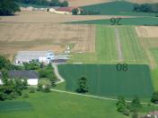
Hofkirchen Airport
VFR Chart of LOLH
Sectional Charts at SkyVector.com
IFR Chart of LOLH
Enroute Charts at SkyVector.com
Location Information for LOLH
Coordinates: N48°8.35' / E14°20.20'View all Airports in Oberösterreich, Austria.
Elevation is 1175.0 feet MSL.
Operations Data
|
|
Nearby Navigation Aids
|
| ||||||||||||||||||||||||||||||||||||||||||||||||||||||||||||
Runway
| Surface: | Hard | |
|---|---|---|
Nearby Airports with Instrument Procedures
| ID | Name | Heading / Distance | ||
|---|---|---|---|---|
 |
LOWL | Linz Airport | 314° | 8.3 |
 |
LOWS | Salzburg Airport | 249° | 57.6 |
 |
LOXZ | Zeltweg Airport | 163° | 58.6 |
 |
LOWG | Graz Airport | 146° | 82.1 |
 |
LOIJ | St Johann/Tirol Airport | 244° | 84.9 |
 |
EDMS | Straubing Wallmuhle Airport | 302° | 85.7 |
 |
LOWW | Wien Schwechat Airport | 090° | 89.8 |
 |
LOWK | Klagenfurt Airport | 179° | 89.8 |
 |
LKNA | Namest Airport | 048° | 94.1 |
 |
EDDM | Muenchen Airport | 278° | 103.1 |
 |
LKTB | Brno Turany Airport | 056° | 111.8 |
 |
LJMB | Maribor/Orehova Vas Airport | 150° | 113.8 |


Comments
Nette Erfahrung
Sehr schönes Flugfeld mit freundlichen und hilfsbereiten Menschen.
W.Kothgassner