


Login
Register
LOWI
Innsbruck Airport
VFR Chart of LOWI
Sectional Charts at SkyVector.com
IFR Chart of LOWI
Enroute Charts at SkyVector.com
Location Information for LOWI
Coordinates: N47°15.62' / E11°20.63'View all Airports in Tirol, Austria.
Elevation is 1907.0 feet MSL.
Operations Data
|
|
Airport Communications
| INNSBRUCK RADAR Approach: | 128.97 |
|---|---|
| INNSBRUCK INFORMATION ATIS: | 126.03 |
| INNSBRUCK Emergency: | 121.50 |
| INNSBRUCK TOWER Tower: | 120.10 |
Nearby Navigation Aids
|
| ||||||||||||||||||||||||||||||||||||||||||||||||||||||||||||


Runway 08/26
| Dimensions: | 6562 x 148 feet / 2000 x 45 meters | |
|---|---|---|
| Surface: | Hard | |
| Runway 08 | Runway 26 | |
| Coordinates: | N47°15.53' / E11°19.90' | N47°15.70' / E11°21.42' |
| Elevation: | 1906 | 1893 |
| Runway Heading: | 077° | 257° |
| Displaced Threshold: | 197 Feet | |
Nearby Airports with Instrument Procedures
| ID | Name | Heading / Distance | ||
|---|---|---|---|---|
 |
LOIJ | St Johann/Tirol Airport | 070° | 47.7 |
|
LIPB | Bolzano Airport | 180° | 48.0 |
|
EDMO | Oberpfaffenhofen Airport | 357° | 49.4 |
|
ETSA | Landsberg/Lech Airport | 340° | 51.8 |
|
ETSL | Lechfeld Airport | 340° | 58.9 |
|
EDJA | Memmingen Airport | 314° | 62.6 |
|
EDDM | Muenchen Airport | 015° | 68.0 |
|
EDMA | Augsburg Airport | 346° | 71.9 |
|
LSZR | St Gallen Altenrhein Airport | 281° | 73.9 |
|
LOWS | Salzburg Airport | 063° | 74.7 |
|
LIDT | Trento/Mattarello Airport | 187° | 74.8 |
|
EDNY | Friedrichshafen Airport | 288° | 78.6 |
Airport Images

By: Avnerd11
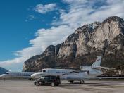
By: Rasanu2000@Gmail.com



Comments
Web page
Hi, after selecting any airport information, details about Nearby Navigations Aids are displayed in two columns.
While viewing your web page in portrait view this could be handy to have this information in single column like eg nearby airprts are.
Thanks