Login
Register


LTBH
Canakkale Airport
VFR Chart of LTBH
Sectional Charts at SkyVector.com
IFR Chart of LTBH
Enroute Charts at SkyVector.com
Location Information for LTBH
Coordinates: N40°8.30' / E26°25.67'View all Airports in Çanakkale, Turkey.
Elevation is 30.0 feet MSL.
Operations Data
|
|
Airport Communications
| CANAKKALE Emergency: | 121.50 |
|---|---|
| CANAKKALE Emergency: | 243.00 |
| CANAKKALE Ground Control: | 121.85 |
| CANAKKALE Tower: | 123.60 |
| CANAKKALE Tower: | 128.25 |
Nearby Navigation Aids
|
| ||||||||||||||||||||||||||||||||||||||||||||||||||||||||||||


Runway 04/22
| Dimensions: | 7710 x 148 feet / 2350 x 45 meters | |
|---|---|---|
| Surface: | Hard | |
| Runway 04 | Runway 22 | |
| Coordinates: | N40°7.64' / E26°24.92' | N40°8.60' / E26°26.01' |
| Elevation: | 20 | 30 |
| Runway Heading: | 038° | 218° |
Nearby Airports with Instrument Procedures
| ID | Name | Heading / Distance | ||
|---|---|---|---|---|
 |
LTFK | Gokceada Airport | 278° | 25.4 |
|
LTFD | Balikesir/Koca Seyit Airport | 142° | 44.3 |
|
LGAL | Dimokritos Airport | 333° | 48.1 |
|
LGLM | Ifaistos Airport | 256° | 56.5 |
|
LGMT | Odysseas Elytis Airport | 172° | 65.3 |
|
LTBG | Balikesir/Bandirma Airport | 080° | 72.0 |
|
LTBF | Balikesir/Merkez Airport | 113° | 75.9 |
|
LTBU | Corlu - Ataturk / International Airport | 048° | 90.0 |
|
LGKV | Megas Alexandros Airport | 299° | 94.9 |
|
LTFA | Izmir Kaklic Airport | 165° | 100.1 |
|
LTBL | Izmir Cigli Airport | 164° | 100.3 |
|
LTBT | Manisa/Akhisar Airport | 140° | 103.1 |
Airport Images
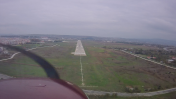
By: TamerHaliloglu


Comments
ATIS FREQ
ATIS FREQ 129.375
General Aviation Terminal access charges:
General Aviation Terminal access charges:
Airports in Türkiye with General Aviation Terminals charges high access prices, unless you are an AOPA member. Contact AOPA Türkiye for up to date information.
LTBH has no GAT and it is just 5 kilometers from ancient Troy City