Login
Register
LTBS
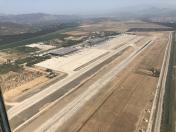
Mugla/Dalaman International Airport
VFR Chart of LTBS
Sectional Charts at SkyVector.com
IFR Chart of LTBS
Enroute Charts at SkyVector.com
Location Information for LTBS
Coordinates: N36°42.75' / E28°47.48'View all Airports in Mugla, Turkey.
Elevation is 20.0 feet MSL.
Operations Data
|
|
Airport Communications
| DALAMAN APPROACH Approach: | 119.22 |
|---|---|
| DALAMAN APPROACH Approach: | 122.40 |
| DALAMAN APPROACH Approach: | 124.40 |
| DALAMAN APPROACH Approach: | 126.05 |
| DALAMAN APPROACH Approach: | 362.30 |
| DALAMAN INFORMATION ATIS: | 127.35 |
| DALAMAN Emergency: | 121.50 |
| DALAMAN Emergency: | 243.00 |
| DALAMAN GROUND Ground Control: | 121.90 |
| DALAMAN TOWER Tower: | 118.50 |
| DALAMAN TOWER Tower: | 128.90 |
| DALAMAN TOWER Tower: | 257.80 |
Nearby Navigation Aids
|
| ||||||||||||||||||||||||||||||||||||||||||||||||||||||||||||
Runway 01/19
| Dimensions: | 9843 x 148 feet / 3000 x 45 meters | |
|---|---|---|
| Surface: | Hard | |
| Runway 01 | Runway 19 | |
| Coordinates: | N36°42.01' / E28°47.28' | N36°43.57' / E28°47.82' |
| Elevation: | 10 | 20 |
| Runway Heading: | 011° | 191° |
Nearby Airports with Instrument Procedures
| ID | Name | Heading / Distance | ||
|---|---|---|---|---|
 |
LGRP | Diagoras Airport | 241° | 38.7 |
 |
LTFE | Mulga/Milas-Bodrum Airport | 301° | 63.0 |
 |
LTAY | Denizli-Cardak AB Airport | 033° | 77.9 |
 |
LTBD | Aydin/Cildir Airport | 327° | 79.0 |
 |
LGKO | Ippokratis Airport | 273° | 82.1 |
 |
LTAI | Antalya Airport | 082° | 97.1 |
 |
LTFC | Isparta / Suleyman Demirel Airport | 047° | 101.9 |
 |
LTFB | Izmir-Selcuk/Efes Airport | 317° | 101.9 |
 |
LGSM | Aristarchos of Samos Airport | 303° | 107.4 |
 |
LGKP | Karpathos Airport | 226° | 111.3 |
 |
LTBO | Usak Airport | 015° | 122.4 |
 |
LTBJ | Izmir Adnan Menderes International Airport | 320° | 122.6 |


Comments
General Aviation Terminal access charge
General Aviation Terminal access charges:
Airports in Türkiye with General Aviation Terminals charges high access prices, unless you are an AOPA member. Contact AOPA Türkiye for up to date information.