Login
Register
N07
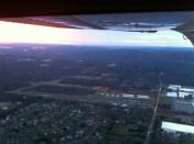
Lincoln Park Airport
Official FAA Data Effective 2025-12-25 0901Z
VFR Chart of N07
Sectional Charts at SkyVector.com
IFR Chart of N07
Enroute Charts at SkyVector.com
Location Information for N07
Coordinates: N40°56.86' / W74°18.87'Located 02 miles N of Lincoln Park, New Jersey on 168 acres of land. View all Airports in New Jersey.
Surveyed Elevation is 181 feet MSL.
Operations Data
|
|
Airport Communications
| NEWARK APPROACH: | 127.6 379.9 |
|---|---|
| NEWARK DEPARTURE: | 127.6 379.9 |
| UNICOM: | 122.800 |
| CTAF: | 122.800 |
| MAZIE STAR: | 379.9 |
| ASOS at CDW (4.5 S): | 135.5 631-594-4523 |
| ATIS at CDW (4.6 S): | 135.5 |
| AWOS-3 at MMU (9.6 SW): | 973-290-0135 |
Nearby Navigation Aids
|
| ||||||||||||||||||||||||||||||||||||||||||||||||||||||||||||
Runway 01/19
| Dimensions: | 2767 x 40 feet / 843 x 12 meters | |
|---|---|---|
| Surface: | Asphalt in Good Condition | |
| Edge Lighting: | High Intensity | |
| Runway 01 | Runway 19 | |
| Coordinates: | N40°56.63' / W74°18.85' | N40°57.08' / W74°18.89' |
| Elevation: | 177.0 | 180.6 |
| Traffic Pattern: | Left | Left |
| Runway Heading: | 355° True | 175° True |
| Displaced Threshold: | 690 Feet | 95 Feet |
| Markings: | Non-Precision Instrument in good condition. | Non-Precision Instrument in good condition. |
| Glide Slope Indicator | P2L (4.00° Glide Path Angle) | |
| Obstacles: | 50 ft Trees 200 ft from runway, 60 ft right of center +50 FT TREE LINE 0-680 FT AND 90-160 FT R; APCH RATIO 0:1 BASED ON DSPLCD THLD. +75 FT TREES 0-200 FT FROM RWY END 250 L - 250 R. |
20 ft Stack 260 ft from runway, 155 ft left of center APCH RATIO 7:1 TO DSPLCD THLD. +30 FT HGR 80 FT FROM RWY END 200 FT L. |
Services Available
| Fuel: | 100LL (blue), Jet-A |
|---|---|
| Transient Storage: | Tiedowns |
| Airframe Repair: | MAJOR |
| Engine Repair: | MAJOR |
| Bottled Oxygen: | LOW |
| Bulk Oxygen: | NONE |
| Other Services: | CHARTER SERVICE,PILOT INSTRUCTION,AIRCRAFT RENTAL,AIRCRAFT SALES |
Ownership Information
| Ownership: | Privately Owned | |
|---|---|---|
| Owner: | LINCOLN PARK AIRPORT INC | |
| 425 BEAVER BROOK ROAD | ||
| LINCOLN PARK, NJ 07035 | ||
| 973-628-7166 | ||
| Manager: | TOM VAN WINGERDEN | |
| 425 BEAVER BROOK ROAD | ||
| LINCOLN PARK, NJ 07035 | ||
| 973-628-7166 | ||
Other Remarks
- NARROW TAXILANES & TWYS CAUSED BY NSTD CLNCS.
- DEER AND BIRDS INVOF RUNWAY.
- TOUCH AND GO LANDINGS PROHIBITED.
- GCO AVBL ON FREQ 121.725. IF UNABLE, CTC NEWARK APCH AT 800-645-3206.
- TSNT HEL OPS ALLOWED WITH PRE-APVL ONLY, CALL 973-628-7166.
- (CONTACT TITLE) FBO CTC (973) 633-0450.
- ACTVT HIRL RY 01/19 - CTAF. ACTVT HIGH INTST FST WITH 7 CLICKS BFR ACTVTNG LOWER INTSTS.
Weather Minimums
Standard Terminal Arrival (STAR) Charts
Instrument Approach Procedure (IAP) Charts
Nearby Airports with Instrument Procedures
| ID | Name | Heading / Distance | ||
|---|---|---|---|---|
 |
KCDW | Essex County Airport | 160° | 4.6 |
 |
KMMU | Morristown Municipal Airport | 207° | 10.0 |
 |
4N1 | Greenwood Lake Airport | 352° | 10.9 |
 |
KTEB | Teterboro Airport | 116° | 12.9 |
 |
KEWR | Newark Liberty International Airport | 156° | 16.7 |
 |
KJRA | West 30th St Heliport | 129° | 18.2 |
 |
12N | Aeroflex/Andover Airport | 280° | 19.6 |
 |
6N5 | East 34th Street Heliport | 128° | 19.9 |
 |
KLDJ | Linden Airport | 170° | 20.1 |
 |
KJRB | Downtown Manhattan/Wall St Heliport | 136° | 20.3 |
 |
KFWN | Sussex Airport | 317° | 20.6 |
 |
KLGA | Laguardia Airport | 116° | 22.6 |


