Login
Register
OIHR
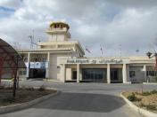
Arak Airport
VFR Chart of OIHR
Sectional Charts at SkyVector.com
IFR Chart of OIHR
Enroute Charts at SkyVector.com
Location Information for OIHR
Coordinates: N34°8.22' / E49°50.52'View all Airports in Markazi, Iran.
Elevation is 5453.0 feet MSL.
Operations Data
|
|
Airport Communications
| ARAK Information: | 118.65 |
|---|
Nearby Navigation Aids
|
| ||||||||||||||||||||||||||||||||||||||||||||||||||||||||||||
Runway 08/26
| Dimensions: | 12139 x 148 feet / 3700 x 45 meters | |
|---|---|---|
| Surface: | Hard | |
| Runway 08 | Runway 26 | |
| Coordinates: | N34°8.10' / E49°49.66' | N34°8.48' / E49°52.02' |
| Elevation: | 5447 | 5453 |
| Runway Heading: | 075° | 255° |
Nearby Airports with Instrument Procedures
| ID | Name | Heading / Distance | ||
|---|---|---|---|---|
 |
OIHH | Hamadan Airport | 304° | 77.6 |
 |
OIFK | Kashan Airport | 099° | 87.7 |
 |
OICK | Khoram Abad Airport | 242° | 88.6 |
 |
OIIE | Tehran/Imam Khomaini Airport | 039° | 100.3 |
 |
OIIP | Karaj/Payam Airport | 025° | 109.7 |
 |
OIFE | Esfahan Hesa Airport | 129° | 112.6 |
 |
OIII | Tehran-Mehrabad Airport | 037° | 118.0 |
 |
OIFS | Sharhe Kord Airport | 155° | 121.1 |
 |
OIAD | Dezful Airport | 216° | 125.7 |
 |
OIFP | Badr Air Base Airport | 133° | 129.9 |
 |
OIFM | Esfahan Airport | 128° | 131.1 |
 |
OICC | Kermanshah Airport | 276° | 134.2 |


Comments
Hi
Arak airport runway length of 3700 meters. PCN is also 65. This airport have VOR/DME & lighting system. All facilities for all types of aircraft takeoff and Landing is also available.
Arak Airport in 2014 has been repaired and restored.
Pages