Login
Register


PHO
Point Hope Airport
Official FAA Data Effective 2025-12-25 0901Z
Chart Supplement

VFR Chart of PAPO
Sectional Charts at SkyVector.com
IFR Chart of PAPO
Enroute Charts at SkyVector.com
Location Information for PAPO
Coordinates: N68°20.89' / W166°47.95'Located 02 miles SW of Point Hope, Alaska on 22 acres of land. View all Airports in Alaska.
Surveyed Elevation is 20 feet MSL.
Operations Data
|
|
Airport Communications
| AWOS-3P: | 118.325 Tel. 907-368-2128 |
|---|---|
| CTAF: | 122.800 |
| AWOS-3 at LUR (35.0 NE): | 907-552-9730 |
- APCH/DEP SVC PRVDD BY ANCHORAGE ARTCC ON FREQS 119.65/363.25(CAPE LISBURNE RCAG).
- COMMUNICATIONS PRVDD BY KOTZEBUE FSS ON FREQ 122.25 (POINT HOPE RCO).
Nearby Navigation Aids
|
| ||||||||||||||||||||||||


Runway 03/21
| Dimensions: | 4000 x 75 feet / 1219 x 23 meters | |
|---|---|---|
| Surface: | Asphalt in Good Condition 1-3 IN CRACKS ACRS WIDTH SPACED 200-500 FT ENTR LENGTH. | |
| Edge Lighting: | Medium Intensity | |
| Runway 03 | Runway 21 | |
| Coordinates: | N68°20.62' / W166°48.47' | N68°21.15' / W166°47.43' |
| Elevation: | 19.5 | 19.5 |
| Traffic Pattern: | Left | Left |
| Runway Heading: | 36° True | 216° True |
| Markings: | Non-Precision Instrument in good condition. | Non-Precision Instrument in good condition. |
| Glide Slope Indicator | P4R (3.00° Glide Path Angle) | P4L (3.00° Glide Path Angle) |
Services Available
| Fuel: | NONE |
|---|---|
| Transient Storage: | Tiedowns |
| Airframe Repair: | NOT AVAILABLE |
| Engine Repair: | NOT AVAILABLE |
| Bottled Oxygen: | NOT AVAILABLE |
| Bulk Oxygen: | NOT AVAILABLE |
Ownership Information
| Ownership: | Publicly owned | |
|---|---|---|
| Owner: | ALASKA DOT&PF NORTHERN REGION | |
| 2301 PEGER ROAD | ||
| FAIRBANKS, AK 99709 | ||
| 907-451-2200 | ||
| Manager: | ALVIN WERNEKE | |
| PO BOX 55 | ||
| KOTZEBUE, AK 99752 | ||
| 907-442-3147 | ||
Other Remarks
- RWY COND UNMNT; RCMND VISUAL INSP PRIOR TO LNDG.
- FUEL AVBL EMERG ONLY.
- WX CAMERA AVBL ON INTERNET AT HTTPS://WEATHERCAMS.FAA.GOV
- NORTHWEST ARCTIC BOROUGH
- ACTVT PAPI RWY 03/21; MIRL RWY 03/21 - CTAF.
Weather Minimums

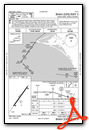
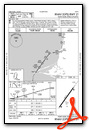
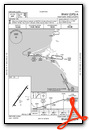
Instrument Approach Procedure (IAP) Charts
Nearby Airports with Instrument Procedures
| ID | Name | Heading / Distance | ||
|---|---|---|---|---|
 |
PAVL | Kivalina Airport | 125° | 62.4 |
Airport Images
Do you have a recent image of this airport? Upload it here!


