Login
Register


SBCT
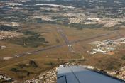
Afonso Pena International Airport
VFR Chart of SBCT
Sectional Charts at SkyVector.com
IFR Chart of SBCT
Enroute Charts at SkyVector.com
Location Information for SBCT
Coordinates: S25°31.90' / W49°10.57'View all Airports in Paraná, Brazil.
Elevation is 2989.0 feet MSL.
Operations Data
|
|
Airport Communications
| CURITIBA CONTROL Approach: | 119.95 |
|---|---|
| CURITIBA CONTROL Approach: | 120.65 |
| CURITIBA CONTROL Approach: | 120.95 |
| CURITIBA CONTROL Approach: | 129.55 |
| CURITIBA CONTROL Approach: | 133.15 |
| CURITIBA ATIS: | 127.80 |
| CURITIBA CLEARANCE Clearance Delivery: | 119.30 |
| CURITIBA Emergency: | 121.50 |
| CURITIBA GROUND Ground Control: | 121.90 |
| CURITIBA TOWER Tower: | 118.15 |
Nearby Navigation Aids
|
| ||||||||||||||||||||||||||||||||||||||||||||||||||||||||||||


Runway 15/33
| Dimensions: | 7277 x 148 feet / 2218 x 45 meters | |
|---|---|---|
| Surface: | Hard | |
| Runway 15 | Runway 33 | |
| Coordinates: | S25°31.33' / W49°10.97' | S25°32.17' / W49°10.03' |
| Elevation: | 2972 | 2987 |
| Runway Heading: | 155° | 335° |
Runway 11/29
| Dimensions: | 5899 x 148 feet / 1798 x 45 meters | |
|---|---|---|
| Surface: | Unknown | |
| Runway 11 | Runway 29 | |
| Coordinates: | S25°31.70' / W49°10.81' | S25°31.73' / W49°9.74' |
| Elevation: | 2974 | 2964 |
| Runway Heading: | 112° | 292° |
Nearby Airports with Instrument Procedures
| ID | Name | Heading / Distance | ||
|---|---|---|---|---|
 |
SBBI | Bacacheri Airport | 337° | 8.3 |
|
SBJV | Lauro Carneiro De Loyola Airport | 153° | 46.1 |
|
SBPG | Comandante Antonio Amilton Ber Airport | 291° | 56.6 |
|
SBNF | Ministro Victor Konder International Airport | 160° | 85.4 |
|
SBCD | Cacador Airport | 231° | 121.4 |
|
SSGG | Aeroporto Regional De Guarapua Airport | 273° | 127.8 |
|
SBSP | Congonhas Airport | 050° | 178.8 |
|
SBST | Santos Airport | 059° | 184.1 |
Airport Images

By: Ramon Schaeffer
By: Daniel Gonzalez


