Login
Register


TWF
Joslin Field/Magic Valley Regional Airport
Official FAA Data Effective 2026-01-22 0901Z
Chart Supplement

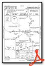
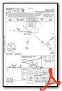
KTWF Airport Diagram

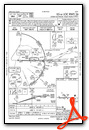
VFR Chart of KTWF
Sectional Charts at SkyVector.com
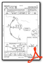
IFR Chart of KTWF
Enroute Charts at SkyVector.com
Location Information for KTWF
Coordinates: N42°28.91' / W114°29.26'Located 04 miles S of Twin Falls, Idaho on 1468 acres of land. View all Airports in Idaho.
Surveyed Elevation is 4153 feet MSL.
Operations Data
|
|
Airport Communications
| ASOS: | 135.025 Tel. 208-733-1878 |
|---|---|
| TWIN FALLS TOWER: | 118.2 317.5 |
| TWIN FALLS GROUND: | 121.7 |
| TWIN FALLS APPROACH: | 126.7 353.75 |
| TWIN FALLS DEPARTURE: | 126.7 353.75 |
| CLEARANCE DELIVERY: | 123.65 |
| UNICOM: | 122.950 |
| CTAF: | 118.200 |
| ASOS at JER (14.8 N): | 135.225 208-324-7076 |
| AWOS-3PT at GNG (28.8 NW): | 124.175 208 934 4950 |
| AWOS-AV at 06U (31.0 S): | 120.00 775-755-2297 |
- APCH/DEP CTL SVC PRVDD BY SALT LAKE ARTCC (ZLC) ON FREQS 118.05/363.0 (BURLEY RCAG) WHEN TWIN FALLS APCH CTL (TWF) CLSD.
Nearby Navigation Aids
|
| ||||||||||||||||||||||||||||||||||||||||||||||||


Runway 08/26
| Dimensions: | 8704 x 150 feet / 2653 x 46 meters | |
|---|---|---|
| Surface: | Asphalt / Porous Friction Course in Good Condition | |
| Weight Limits: | S-75, D-200, ST-250
PCR VALUE: 1020/F/B/X/T
| |
| Edge Lighting: | High Intensity | |
| Runway 08 | Runway 26 | |
| Coordinates: | N42°28.88' / W114°30.19' | N42°28.84' / W114°28.26' |
| Elevation: | 4143.7 | 4151.5 |
| Traffic Pattern: | Left | Left |
| Runway Heading: | 91° True | 271° True |
| Markings: | Non-Precision Instrument in good condition. | Precision Instrument in good condition. |
| Glide Slope Indicator | V4L (3.00° Glide Path Angle) | P4L (3.00° Glide Path Angle) |
| Approach Lights: | MALSR 1,400 Foot Medium-intensity Approach Lighting System with runway alignment indicator lights. | |
| REIL: | Yes | |
Runway 12/30
NON ACR MOV AREA. | ||
| Dimensions: | 3224 x 75 feet / 983 x 23 meters | |
|---|---|---|
| Surface: | Asphalt in Fair Condition | |
| Weight Limits: | S-19
PCR VALUE: 157/F/B/X/T
| |
| Runway 12 | Runway 30 | |
| Coordinates: | N42°29.23' / W114°29.62' | N42°28.85' / W114°29.12' |
| Elevation: | 4106.7 | 4147.5 |
| Traffic Pattern: | Left | Left |
| Runway Heading: | 136° True | 316° True |
| Markings: | Basic in good condition. | Basic in good condition. |
| Obstacles: | 75 ft Trees 2000 ft from runway | |
Services Available
| Fuel: | 100LL (blue), Jet A-1+ |
|---|---|
| Transient Storage: | Hangars,Tiedowns |
| Airframe Repair: | MAJOR |
| Engine Repair: | MAJOR |
| Bottled Oxygen: | HIGH |
| Bulk Oxygen: | HIGH |
| Other Services: | AIR FREIGHT SERVICES,CROP DUSTING SERVICES,CARGO HANDLING SERVICES,CHARTER SERVICE,PILOT INSTRUCTION |
Ownership Information
| Ownership: | Publicly owned | |
|---|---|---|
| Owner: | CITY OF TWIN FALLS | |
| P.O. BOX 1907 | ||
| TWIN FALLS, ID 83303 | ||
| 208-733-5215 | ||
| Manager: | BILL CARBERRY | |
| P.O. BOX 1907 | ||
| TWIN FALLS, ID 83303 | ||
| 208-733-5215 | ||
Other Remarks
- TWY G, H, J & K NON ACR MOV AREA.
- LN OF SIGHT BTN RWY 26 APCH END & RWY 12 APCH END NA.
- FOR CD IF UNA TO CTC ON FSS FREQ, CTC SALT LAKE ARTCC AT 801-320-2568.
- 0LL SVC FEE 2000-0630; INFO 208-733-5920 OR 539-4034.
- WHEN ATCT CLSD ACTVT MALSR RWY 26; REIL RWY 08; HIRL RWY 08/26 - CTAF.
Weather Minimums

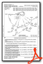
Instrument Approach Procedure (IAP) Charts


Departure Procedure (DP) Charts
Nearby Airports with Instrument Procedures
| ID | Name | Heading / Distance | ||
|---|---|---|---|---|
 |
KJER | Jerome County Airport | 005° | 14.8 |
|
KGNG | Gooding Municipal Airport | 334° | 28.9 |
|
KBYI | Burley Municipal Airport | 083° | 32.0 |
|
KSUN | Friedman Memorial Airport | 007° | 61.9 |
|
U76 | Mountain Home Municipal Airport | 305° | 67.3 |
|
KMUO | Mountain Home AFB Airport | 299° | 69.9 |
|
10U | Owyhee Airport | 247° | 81.9 |
|
KAOC | Arco-Butte County Airport | 036° | 84.3 |
|
KPIH | Pocatello Regional Airport | 072° | 87.5 |
|
KBOI | Boise Air Trml/Gowen Field Airport | 310° | 100.2 |
|
U02 | Mccarley Field Airport | 064° | 104.0 |
|
KENV | Wendover Airport | 168° | 107.7 |
Airport Images
Do you have a recent image of this airport? Upload it here!


