Login
Register
ENV
Wendover Airport
Official FAA Data Effective 2025-12-25 0901Z
VFR Chart of KENV
Sectional Charts at SkyVector.com
IFR Chart of KENV
Enroute Charts at SkyVector.com
Location Information for KENV
Coordinates: N40°43.12' / W114°1.72'Located 01 miles SE of Wendover, Utah on 1960 acres of land. View all Airports in Utah.
Surveyed Elevation is 4236 feet MSL.
Operations Data
|
|
Airport Communications
| AWOS-3PT: | 120.55 Tel. 435-665-2521 |
|---|---|
| CTAF: | 122.800 |
| UNICOM: | 122.800 |
| ASOS at U19 (45.6 SE): | |
| ASOS at U16 (47.5 NE): | |
| AWOS-3PT at TVY (76.6 E): | 119.725 435-882-6648 |
- COMMUNICATIONS PRVDD BY CEDAR CITY RADIO ON FREQ 122.1R 112.3T (BONNEVILLE RCO).
- APCH/DEP CTL SVC PRVDD BY SALT LAKE ARTCC (ZLC) ON 128.55/269.175 GRASSY MOUNTAIN RCAG).
Nearby Navigation Aids
|
| ||||||||||||||||||||||||||||||||||||
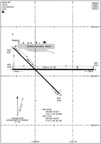
Runway 08/26
| Dimensions: | 10002 x 150 feet / 3049 x 46 meters | |
|---|---|---|
| Surface: | Asphalt / Grooved in Good Condition | |
| Weight Limits: | S-75, D-140, ST-208
PCR VALUE: 490/F/D/X/T
| |
| Edge Lighting: | Medium Intensity | |
| Runway 08 | Runway 26 | |
| Coordinates: | N40°43.14' / W114°2.61' | N40°43.14' / W114°0.44' |
| Elevation: | 4229.7 | 4226.4 |
| Traffic Pattern: | Right | |
| Runway Heading: | 90° True | 270° True |
| Declared Distances: | TORA:10002 TODA:10002 ASDA:10002 LDA:10002 | TORA:10002 TODA:10002 ASDA:10002 LDA:10002 |
| Markings: | Precision Instrument in good condition. | Precision Instrument in good condition. |
| Glide Slope Indicator | P4L (3.00° Glide Path Angle) | P4L (3.00° Glide Path Angle) |
| REIL: | Yes | Yes |
Runway 12/30
| Dimensions: | 8002 x 100 feet / 2439 x 30 meters | |
|---|---|---|
| Surface: | Asphalt / Grooved in Fair Condition | |
| Weight Limits: | S-75, D-140, ST-180
PCR VALUE: 560/F/D/X/T
| |
| Edge Lighting: | Medium Intensity | |
| Runway 12 | Runway 30 | |
| Coordinates: | N40°43.57' / W114°2.58' | N40°42.64' / W114°1.35' |
| Elevation: | 4236.7 | 4224.3 |
| Traffic Pattern: | Right | Left |
| Runway Heading: | 135° True | 315° True |
| Declared Distances: | TORA:8002 TODA:8002 ASDA:8002 LDA:8002 | TORA:8002 TODA:8002 ASDA:8002 LDA:8002 |
| Markings: | Non-Precision Instrument in good condition. | Non-Precision Instrument in good condition. |
| Glide Slope Indicator | P4L (3.00° Glide Path Angle) | |
| REIL: | Yes | Yes |
Services Available
| Fuel: | 100 (green), Jet-A |
|---|---|
| Transient Storage: | Hangars |
| Airframe Repair: | MINOR |
| Engine Repair: | MINOR |
| Bottled Oxygen: | NOT AVAILABLE |
| Bulk Oxygen: | NOT AVAILABLE |
Ownership Information
| Ownership: | Publicly owned | |
|---|---|---|
| Owner: | TOOELE COUNTY | |
| P.O. BOX 159 | ||
| WENDOVER, UT 84083 | ||
| 435-843-3360 | ||
| Manager: | LISA DUNN | |
| P.O. BOX 159 | ||
| WENDOVER, UT 84083 | ||
| 435-843-3360 | ||
Other Remarks
- COLD TEMPERATURE AIRPORT. ALTITUDE CORRECTION REQUIRED AT OR BELOW -12C.
- ACTVT REIL RWY 08, 12, 26, 30; PAPI RWY 08, 26, 30; MIRL RWY 08/26 & 12/30 - CTAF.
Weather Minimums
Instrument Approach Procedure (IAP) Charts
Departure Procedure (DP) Charts
Nearby Airports with Instrument Procedures
| ID | Name | Heading / Distance | ||
|---|---|---|---|---|
 |
KTVY | Bolinder Field/Tooele Valley Airport | 094° | 76.9 |
 |
KEKO | Elko Regional Airport | 275° | 80.6 |
 |
KSVR | South Valley Regional Airport | 092° | 93.1 |
 |
KELY | Ely/Yelland Field Airport | 204° | 93.0 |
 |
KSLC | Salt Lake City International Airport | 086° | 93.6 |
 |
KOGD | Ogden-Hinckley Airport | 072° | 96.0 |
 |
KHIF | Hill AFB Airport | 074° | 96.6 |
 |
KBMC | Brigham City Regional Airport | 060° | 102.3 |
 |
KDTA | Delta Municipal Airport | 138° | 106.6 |
 |
KTWF | Joslin Field/Magic Valley Regional Airport | 349° | 107.7 |
 |
KPVU | Provo Municipal Airport | 105° | 109.7 |
 |
KBYI | Burley Municipal Airport | 005° | 110.0 |


