Login
Register


TZT
Belle Plaine Municipal Airport
Official FAA Data Effective 2025-11-27 0901Z
Chart Supplement

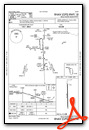
VFR Chart of KTZT
Sectional Charts at SkyVector.com
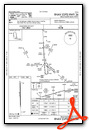
IFR Chart of KTZT
Enroute Charts at SkyVector.com
Location Information for KTZT
Coordinates: N41°52.73' / W92°17.07'Located 01 miles SW of Belle Plaine, Iowa on 96 acres of land. View all Airports in Iowa.
Surveyed Elevation is 771 feet MSL.
Operations Data
|
|
Airport Communications
| CEDAR RAPIDS APPROACH: | 119.7 266.8 |
|---|---|
| CEDAR RAPIDS DEPARTURE: | 119.7 266.8 |
| CTAF: | 122.900 |
| AWOS-3 at GGI (22.6 SW): | 120.725 641-236-9720 |
| AWOS-3 at VTI (23.4 NE): | 120.075 319-472-3122 |
| ATIS at CID (25.6 E): | 124.15 |
- APCH/DEP SVC PRVDD BY CHICAGO ARTCC ON FREQS 132.8/328.4 (CEDAR RAPIDS RCAG) WHEN CEDAR RAPIDS APCH CTL CLSD.
Nearby Navigation Aids
|
| ||||||||||||||||||||||||||||||||||||

Runway 18/36
| Dimensions: | 4001 x 75 feet / 1220 x 23 meters | |
|---|---|---|
| Surface: | Concrete in Good Condition | |
| Weight Limits: | 6 /R/C/W/U | |
| Edge Lighting: | Medium Intensity | |
| Runway 18 | Runway 36 | |
| Coordinates: | N41°53.06' / W92°17.09' | N41°52.40' / W92°17.05' |
| Elevation: | 771.0 | 768.8 |
| Runway Heading: | 177° True | 357° True |
| Markings: | Non-Precision Instrument in good condition. | Non-Precision Instrument in good condition. |
| Obstacles: | 41 ft Tree 955 ft from runway, 320 ft right of center | 80 ft Tree 2589 ft from runway, 20 ft left of center |
Services Available
| Fuel: | NONE |
|---|---|
| Transient Storage: | Tiedowns |
| Airframe Repair: | NONE |
| Engine Repair: | NONE |
| Bottled Oxygen: | NOT AVAILABLE |
| Bulk Oxygen: | NOT AVAILABLE |
Ownership Information
| Ownership: | Publicly owned | |
|---|---|---|
| Owner: | CITY OF BELLE PLAINE | |
| 8TH AVE & 13TH ST. | ||
| BELLE PLAINE, IA 52208 | ||
| 319-444-2200 | ||
| Manager: | STEPHEN BECK | CITY ADMINISTRATOR |
| 1207 - 8TH AVENUE | ||
| BELLE PLAINE, IA 52208 | ||
| 319-310-3918 | ||
Other Remarks
- TREES ON BOTH SIDES OF APCH TO RWY 36 PENETRATE THE RWY TRSNL SFC.
- WILDLIFE ON AND BIRDS INVOF ARPT.
- FOR CD CTC CHICAGO ARTCC AT 630-906-8921.
- ACTVT MIRL RY 18/36 - CTAF.
Weather Minimums

Instrument Approach Procedure (IAP) Charts
Nearby Airports with Instrument Procedures
| ID | Name | Heading / Distance | ||
|---|---|---|---|---|
 |
KGGI | Grinnell Regional Airport | 243° | 22.7 |
|
KVTI | Vinton Veterans Memorial Airpark Airport | 029° | 23.4 |
|
KCID | The Eastern Iowa Airport | 089° | 25.7 |
|
KMIW | Marshalltown Municipal Airport | 296° | 31.6 |
|
C17 | Marion Airport | 074° | 34.9 |
|
KTNU | Newton Municipal-Earl Johnson Field Airport | 249° | 35.3 |
|
KIOW | Iowa City Municipal Airport | 113° | 36.1 |
|
KIIB | James H Connell Field At Independence Municipal Airport | 023° | 37.8 |
|
KOOA | Oskaloosa Municipal Airport | 193° | 40.3 |
|
KALO | Waterloo Regional Airport | 352° | 41.1 |
|
KPEA | Pella Municipal Airport | 226° | 41.3 |
|
KAWG | Washington Municipal Airport | 142° | 45.4 |
Airport Images

By: 2flaps


