Login
Register
SABE
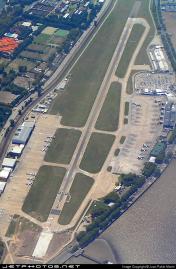
Aeroparque Jorge Newbury Airport
VFR Chart of SABE
Sectional Charts at SkyVector.com
IFR Chart of SABE
Enroute Charts at SkyVector.com
Location Information for SABE
Coordinates: S34°33.58' / W58°24.90'View all Airports in Ciudad de Buenos Aires, Argentina.
Elevation is 20.0 feet MSL.
Operations Data
|
|
Airport Communications
| AEROPARQUE APROXIMACION Approach: | 119.50 |
|---|---|
| AEROPARQUE APROXIMACION Approach: | 120.60 |
| ATIS AEROPARQUE ATIS: | 127.60 |
| ATIS AEROPARQUE ATIS: | 127.90 |
| AEROPARQUE AUTORIZACIONES Clearance Delivery: | 129.30 |
| AEROPARQUE JORGE NEWBURY Emergency: | 121.50 |
| AEROPARQUE RODAJE O SUPER Ground Control: | 121.90 |
| AEROPARQUE TORRE Tower: | 118.25 |
| AEROPARQUE TORRE Tower: | 118.85 |
| AEROPARQUE TORRE Tower: | 128.85 |
Nearby Navigation Aids
|
| ||||||||||||||||||||||||||||||||||||||||||||||||||||||||||||
Runway 13/31
| Dimensions: | 7710 x 148 feet / 2350 x 45 meters | |
|---|---|---|
| Surface: | Hard | |
| Runway 13 | Runway 31 | |
| Coordinates: | S34°33.24' / W58°25.52' | S34°33.83' / W58°24.45' |
| Elevation: | 20 | 16 |
| Runway Heading: | 133° | 313° |
| Displaced Threshold: | 1237 Feet | |
Nearby Airports with Instrument Procedures
| ID | Name | Heading / Distance | ||
|---|---|---|---|---|
 |
SADP | El Palomar Airport | 252° | 10.2 |
 |
SADF | San Fernando Airport | 305° | 10.8 |
 |
SADM | Moron Airport | 237° | 13.4 |
 |
SAEZ | Ezeiza/Ministro Pistarini Airport | 200° | 16.8 |
 |
SADJ | Mariano Moreno Airport | 269° | 18.6 |
 |
SUCA | Laguna De Los Patos International Airport | 078° | 32.8 |
 |
SAAG | Gualeguaychu Airport | 353° | 93.6 |
 |
SUAA | Angel S Adami International Airport | 097° | 107.3 |
 |
SUMU | Montevideo/Carrasco L Berisso Airport | 098° | 119.2 |
 |
SUDU | Durazno/Santa Bernardina International Airport | 053° | 119.9 |
 |
SAAR | Rosario / Islas Malvinas Airport | 309° | 154.6 |


Comments
Nombre correcto de Aeropueeto- Correct Name of this Airport
ESP -El nombre correcto de este Aeropuerto es "Jorge Newbery"
ENG -The correct name of this airport is "Jorge Newbery"
Correct Name
Correct Name is Aeropuerto Jorge Newbery
Pages