Login
Register
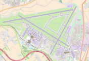
LLBG
Tel Aviv Ben Gurion Airport
VFR Chart of LLBG
Sectional Charts at SkyVector.com
IFR Chart of LLBG
Enroute Charts at SkyVector.com
Location Information for LLBG
Coordinates: N32°0.57' / E34°53.13'View all Airports in HaMerkaz, Israel.
Elevation is 134.0 feet MSL.
Operations Data
|
|
Airport Communications
| BEN GURION Approach: | 120.50 |
|---|---|
| BEN-GURION Approach: | 131.10 |
| BEN-GURION ATIS: | 132.50 |
| BEN-GURION ATIS: | 132.80 |
| BEN-GURION Clearance Delivery: | 118.30 |
| BEN-GURION Clearance, Pre-Taxi: | 129.20 |
| BEN-GURION Emergency: | 121.50 |
| BEN-GURION Ground Control: | 118.05 |
| BEN-GURION Ground Control: | 129.20 |
| BEN-GURION TMA: | 119.50 |
| BEN-GURION Tower: | 132.10 |
| BEN-GURION Tower: | 134.60 |
Nearby Navigation Aids
|
| ||||||||||||||||||||||||||||||||||||||||||||||||||||||||||||
Runway 08/26
| Dimensions: | 13327 x 148 feet / 4062 x 45 meters | |
|---|---|---|
| Surface: | Hard | |
| Runway 08 | Runway 26 | |
| Coordinates: | N32°0.77' / E34°51.65' | N32°1.06' / E34°53.56' |
| Elevation: | 97 | 124 |
| Runway Heading: | 076° | 255° |
| Displaced Threshold: | 1322 Feet | 1982 Feet |
Runway 12/30
| Dimensions: | 10210 x 148 feet / 3112 x 45 meters | |
|---|---|---|
| Surface: | Unknown | |
| Runway 12 | Runway 30 | |
| Coordinates: | N32°0.85' / E34°52.01' | N31°60.00' / E34°53.65' |
| Elevation: | 102 | 130 |
| Runway Heading: | 116° | 296° |
| Displaced Threshold: | 243 Feet | |
Runway 03/21
| Dimensions: | 9094 x 197 feet / 2772 x 60 meters | |
|---|---|---|
| Surface: | Unknown | |
| Runway 03 | Runway 21 | |
| Coordinates: | N31°59.77' / E34°53.16' | N32°1.09' / E34°54.01' |
| Elevation: | 134 | 134 |
| Runway Heading: | 024° | 204° |
Nearby Airports with Instrument Procedures
| ID | Name | Heading / Distance | ||
|---|---|---|---|---|
 |
OJAM | Amman Airport | 091° | 56.5 |
 |
OJAI | Queen Alia-Amman Airport | 106° | 59.2 |
 |
HEAR | El Arish International Airport | 224° | 77.7 |
 |
OLBA | Rafic Hariri Beirut International Airport | 015° | 112.6 |
 |
OSDI | Damascus International Airport | 044° | 117.6 |
 |
OEGT | Guriat Domestic Airport | 105° | 127.6 |
 |
HEPS | Port Said Airport | 252° | 142.4 |


Comments
This is the best airport
this is the best airport!
Ben Gurion TWR frequency is
Ben Gurion TWR frequency is 134.6, secondary is 119.35 (by ATIS only).
121.5 is the emergency frequency obviously.
All Israeli NDBs are decomissioned and no longer available (TAV, BGN, IRM, JYG)
For RWY 08: Displaced threshold of 1329' and RWY HDG is 075M, ILS-CAT-I available
For RWY 26: RWY HDG is 255M, ILS-CAT-I available
RWY12/30 - dimensions: 10210'x148' hard surface
RWY 12: Magentic heading: 116, RWY touchdown elevation: 112', ILS-CAT-I available, Right Traffic
RWY 30: Magnetic heading: 296, RWY touchdown elevation: 130', displaced threshold: 246', ILS-CAT-I available
RWY 03/21: dimensions 9094'x197', hard surface
RWY 03: Magnetic heading: 024, RWY touchdown elevation: 134', No IFR approach available, Right Traffic
RWY 21: Magnetic heading: 204, RWY touchdown elevation: 134', ILS-CAT-I available